Saint-Rabier
Saint-Rabier is a commune in the Dordogne department in Nouvelle-Aquitaine in southwestern France.
Saint-Rabier | |
|---|---|
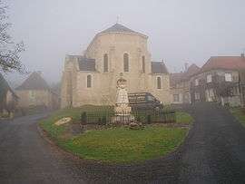 The church in Saint-Rabier | |
Location of Saint-Rabier 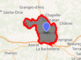
| |
 Saint-Rabier  Saint-Rabier | |
| Coordinates: 45°10′16″N 1°09′08″E | |
| Country | France |
| Region | Nouvelle-Aquitaine |
| Department | Dordogne |
| Arrondissement | Sarlat-la-Canéda |
| Canton | Haut-Périgord Noir |
| Intercommunality | Terrassonnais |
| Government | |
| • Mayor (2008–2014) | Claude Delpy |
| Area 1 | 15.87 km2 (6.13 sq mi) |
| Population (2017-01-01)[1] | 585 |
| • Density | 37/km2 (95/sq mi) |
| Time zone | UTC+01:00 (CET) |
| • Summer (DST) | UTC+02:00 (CEST) |
| INSEE/Postal code | 24491 /24210 |
| Elevation | 117–341 m (384–1,119 ft) (avg. 212 m or 696 ft) |
| 1 French Land Register data, which excludes lakes, ponds, glaciers > 1 km2 (0.386 sq mi or 247 acres) and river estuaries. | |
Population
| Year | Pop. | ±% |
|---|---|---|
| 1962 | 582 | — |
| 1968 | 576 | −1.0% |
| 1975 | 518 | −10.1% |
| 1982 | 580 | +12.0% |
| 1990 | 573 | −1.2% |
| 1999 | 501 | −12.6% |
| 2008 | 550 | +9.8% |
gollark: In what form?
gollark: Oh, and it turns out I broke the author handling a while ago.
gollark: So what I'm looking at now is a way to somehow have it try the next question if it errored.
gollark: Which is to say, not very well, and because the questions search fetches now are different the demo doesn't work.
gollark: Well, it works as well as the original now.
See also
References
- "Populations légales 2017". INSEE. Retrieved 6 January 2020.
| Wikimedia Commons has media related to Saint-Rabier. |
| Authority control |
|
|---|
This article is issued from Wikipedia. The text is licensed under Creative Commons - Attribution - Sharealike. Additional terms may apply for the media files.