Monbazillac
Monbazillac is a commune in the Dordogne department in Nouvelle-Aquitaine in southwestern France.
Monbazillac | |
|---|---|
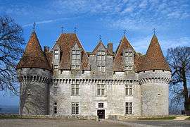 Château de Monbazillac | |
.svg.png) Coat of arms | |
Location of Monbazillac 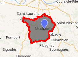
| |
 Monbazillac  Monbazillac | |
| Coordinates: 44°47′42″N 0°29′33″E | |
| Country | France |
| Region | Nouvelle-Aquitaine |
| Department | Dordogne |
| Arrondissement | Bergerac |
| Canton | Sud-Bergeracois |
| Intercommunality | Bergerac Pourpre |
| Government | |
| • Mayor (2008–2014) | Jean-Pierre Peyrebrune |
| Area 1 | 19.58 km2 (7.56 sq mi) |
| Population (2017-01-01)[1] | 829 |
| • Density | 42/km2 (110/sq mi) |
| Time zone | UTC+01:00 (CET) |
| • Summer (DST) | UTC+02:00 (CEST) |
| INSEE/Postal code | 24274 /24240 |
| Elevation | 46–188 m (151–617 ft) (avg. 160 m or 520 ft) |
| 1 French Land Register data, which excludes lakes, ponds, glaciers > 1 km2 (0.386 sq mi or 247 acres) and river estuaries. | |
Population
| Year | Pop. | ±% |
|---|---|---|
| 1800 | 1,112 | — |
| 1831 | 1,204 | +8.3% |
| 1866 | 1,105 | −8.2% |
| 1901 | 873 | −21.0% |
| 1931 | 905 | +3.7% |
| 1962 | 907 | +0.2% |
| 1968 | 846 | −6.7% |
| 1975 | 789 | −6.7% |
| 1982 | 831 | +5.3% |
| 1990 | 902 | +8.5% |
| 1999 | 899 | −0.3% |
| 2008 | 958 | +6.6% |
gollark: Sure you can, it's easy.
gollark: Well, you can send your test stuff and code to me, and it'll run on one of the available osmarks.tk computing servers.
gollark: You need npm too, obviously.
gollark: I mean, you could use osmarks.tk's secondary computing server.
gollark: Nope!
References
- "Populations légales 2017". INSEE. Retrieved 6 January 2020.
| Wikimedia Commons has media related to Monbazillac. |
| Authority control |
|
|---|
This article is issued from Wikipedia. The text is licensed under Creative Commons - Attribution - Sharealike. Additional terms may apply for the media files.