Vatteville
Vatteville is a commune in the Eure department in Normandy in northern France.
Vatteville | |
|---|---|
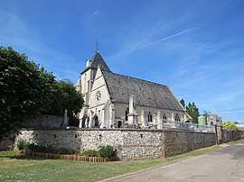 The church in Vatteville | |
Location of Vatteville 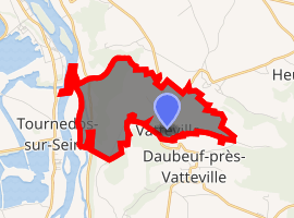
| |
 Vatteville  Vatteville | |
| Coordinates: 49°16′36″N 1°17′44″E | |
| Country | France |
| Region | Normandy |
| Department | Eure |
| Arrondissement | Les Andelys |
| Canton | Les Andelys |
| Government | |
| • Mayor (2008–2014) | Laurent Legay |
| Area 1 | 4.27 km2 (1.65 sq mi) |
| Population (2017-01-01)[1] | 182 |
| • Density | 43/km2 (110/sq mi) |
| Time zone | UTC+01:00 (CET) |
| • Summer (DST) | UTC+02:00 (CEST) |
| INSEE/Postal code | 27673 /27430 |
| Elevation | 7–151 m (23–495 ft) (avg. 150 m or 490 ft) |
| 1 French Land Register data, which excludes lakes, ponds, glaciers > 1 km2 (0.386 sq mi or 247 acres) and river estuaries. | |
The surname "Waterfield" originates from this town.
Population
| Year | Pop. | ±% |
|---|---|---|
| 1962 | 135 | — |
| 1968 | 140 | +3.7% |
| 1975 | 110 | −21.4% |
| 1982 | 144 | +30.9% |
| 1990 | 166 | +15.3% |
| 1999 | 160 | −3.6% |
| 2008 | 183 | +14.4% |
gollark: So, it overrides printError temporarily so it'll be called on crash of that loop.
gollark: That's entirely unrelated.
gollark: Nope.
gollark: Great!
gollark: SPUDNET manages secureish message forwarding, and incident report handling.
See also
References
- "Populations légales 2017". INSEE. Retrieved 6 January 2020.
| Wikimedia Commons has media related to Vatteville. |
| Authority control |
|
|---|
This article is issued from Wikipedia. The text is licensed under Creative Commons - Attribution - Sharealike. Additional terms may apply for the media files.