Boisset-les-Prévanches
Boisset-les-Prévanches is a commune in the Eure department in Normandy in northern France.
Boisset-les-Prévanches | |
|---|---|
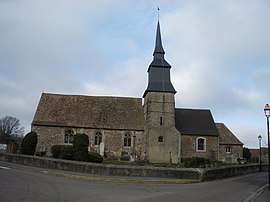 The church in Boisset-les-Prévanches | |
 Coat of arms | |
Location of Boisset-les-Prévanches 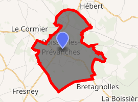
| |
 Boisset-les-Prévanches  Boisset-les-Prévanches | |
| Coordinates: 48°58′08″N 1°19′47″E | |
| Country | France |
| Region | Normandy |
| Department | Eure |
| Arrondissement | Les Andelys |
| Canton | Pacy-sur-Eure |
| Government | |
| • Mayor (2008–2014) | Nicole Delatre |
| Area 1 | 7.46 km2 (2.88 sq mi) |
| Population (2017-01-01)[1] | 468 |
| • Density | 63/km2 (160/sq mi) |
| Time zone | UTC+01:00 (CET) |
| • Summer (DST) | UTC+02:00 (CEST) |
| INSEE/Postal code | 27076 /27120 |
| Elevation | 66–147 m (217–482 ft) (avg. 144 m or 472 ft) |
| 1 French Land Register data, which excludes lakes, ponds, glaciers > 1 km2 (0.386 sq mi or 247 acres) and river estuaries. | |
Population
| Year | Pop. | ±% |
|---|---|---|
| 1962 | 298 | — |
| 1968 | 323 | +8.4% |
| 1975 | 294 | −9.0% |
| 1982 | 292 | −0.7% |
| 1990 | 364 | +24.7% |
| 1999 | 392 | +7.7% |
| 2008 | 436 | +11.2% |
gollark: Specs can be made first-class after a function exists.
gollark: This is not the 1970s.
gollark: Have a callable trait or somerhijgm.
gollark: Functions MUST be first class.
gollark: That is no excuse.
See also
References
- "Populations légales 2017". INSEE. Retrieved 6 January 2020.
| Wikimedia Commons has media related to Boisset-les-Prévanches. |
| Authority control |
|
|---|
This article is issued from Wikipedia. The text is licensed under Creative Commons - Attribution - Sharealike. Additional terms may apply for the media files.