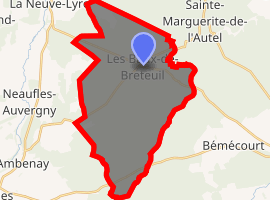
Les Baux-de-Breteuil
Les Baux-de-Breteuil is a commune in the Eure department and Normandy region of northern France.
Les Baux-de-Breteuil | |
|---|---|
Location of Les Baux-de-Breteuil 
| |
 Les Baux-de-Breteuil  Les Baux-de-Breteuil | |
| Coordinates: 48°52′50″N 0°48′46″E | |
| Country | France |
| Region | Normandy |
| Department | Eure |
| Arrondissement | Évreux |
| Canton | Breteuil |
| Intercommunality | CC Interco Normandie Sud Eure |
| Government | |
| • Mayor (2014–2020) | Françoise Leray |
| Area 1 | 34.22 km2 (13.21 sq mi) |
| Population (2017-01-01)[1] | 664 |
| • Density | 19/km2 (50/sq mi) |
| Time zone | UTC+01:00 (CET) |
| • Summer (DST) | UTC+02:00 (CEST) |
| INSEE/Postal code | 27043 /27160 |
| Elevation | 160–199 m (525–653 ft) (avg. 185 m or 607 ft) |
| 1 French Land Register data, which excludes lakes, ponds, glaciers > 1 km2 (0.386 sq mi or 247 acres) and river estuaries. | |
Population
| Year | Pop. | ±% |
|---|---|---|
| 1946 | 720 | — |
| 1954 | 677 | −6.0% |
| 1962 | 656 | −3.1% |
| 1968 | 529 | −19.4% |
| 1975 | 517 | −2.3% |
| 1982 | 564 | +9.1% |
| 1990 | 561 | −0.5% |
| 1999 | 578 | +3.0% |
| 2009 | 661 | +14.4% |
| 2016 | 658 | −0.5% |
gollark: What useful usefulness can you get out of that?
gollark: I'm sure you'd like to think so.
gollark: It's probably harder to accidentally miswrite stuff like that now we have computerized records and automatic spellcheck.
gollark: This clearly vindicates me never* going outside, which has no other detrimental consequences.
gollark: I can't actually do regular pullups. Maybe I should not not do that somehow.
See also
References
- "Populations légales 2017". INSEE. Retrieved 6 January 2020.
| Wikimedia Commons has media related to Les Baux-de-Breteuil. |
This article is issued from Wikipedia. The text is licensed under Creative Commons - Attribution - Sharealike. Additional terms may apply for the media files.