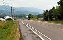
U.S. Route 11W
U.S. Route 11W (US 11W) is a divided highway of US 11 in the U.S. states of Tennessee and Virginia. The U.S. Highway, which is complemented by US 11E to the south and east, runs 111.2 miles (179.0 km) from US 11, US 11E, and US 70 in Knoxville, Tennessee north and east to US 11, US 11E, US 19, and US 421 in Bristol, Virginia. US 11W connects Knoxville and the twin cities of Bristol, Virginia and Bristol, Tennessee with the East Tennessee communities of Rogersville and Kingsport. The U.S. Highway has an unsigned concurrency with Tennessee State Route 1 (SR 1) for its whole length.
| |||||||||
|---|---|---|---|---|---|---|---|---|---|

| |||||||||
| Route information | |||||||||
| Auxiliary route of US 11 | |||||||||
| Length | 111.2 mi[1][2] (179.0 km) | ||||||||
| Existed | 1929–present | ||||||||
| Major junctions | |||||||||
| South end | |||||||||
| |||||||||
| North end | |||||||||
| Location | |||||||||
| States | Tennessee, Virginia | ||||||||
| Counties | TN: Knox, Grainger, Hawkins, Sullivan VA: City of Bristol | ||||||||
| Highway system | |||||||||
| |||||||||
Because of a history consisting of numerous fatal accidents along the highway through-out several decades, with most notoriously being the site of a head-on collision between a bus and a semi-truck in 1972, the highway has garnered an unofficial nickname of "Bloody 11W."[3][4][5]
Route description
US 11W begins at an intersection with the northern terminus of mainline US 11 in Tennessee, the southern end of US 11E, and US 70 in Knoxville. US 11 and US 70 head west as Magnolia Avenue toward Zoo Knoxville and downtown Knoxville; US 11E and US 70 head east along Asheville Highway. US 11W heads northeast as Rutledge Pike, a four-lane divided highway that has a partial cloverleaf interchange with Interstate 40 (I-40) before leaving the city of Knoxville at its underpass of I-640 and US 25W. The U.S. Highway crosses to the north side of Norfolk Southern Railway's Knoxville East District and passes between the community of Mascot to the south and House Mountain to the north. US 11W crosses the Knox–Grainger county line and reduces to a two-lane road before intersecting SR 61 in Blaine. North of Blaine, the highway follows Richland Creek northeast through the Richland Valley between the Richland Knobs to the south and the Poor Valley Knobs to the north.[1]

US 11W meets the northern end of SR 92 in the town of Rutledge, the county seat of Grainger County. The U.S. Highway passes along a narrow strip of flat land between the Valley Ridge to the north and Cherokee Lake, an impoundment of the Holston River. East of Tate Springs near the eastern end of the lake's T-shaped northern end, US 11W has an interchange with US 25E (Dixie Highway). The two highways head east on Old Lee Highway, a four-lane divided highway, toward Bean Station. SR 1 continues east on its own path as Old Lee Highway through the center of Bean Station while US 11 and US 25E head southeast on New Lee Highway. The two U.S. Highways then separate at a trumpet interchange; US 11W heads northeast as a four-lane divided highway that receives the eastern end of the unaccompanied section of SR 1 and enters Hawkins County.[1]
US 11W meets the southern end of SR 31 (Flat Gap Road) in Mooresburg. After crossing Poor Valley Creek, the highway begins to parallel the Holston River to the south and Short Mountain on the north. At Marble Hall, US 11W veers southeast into the valley of Crockett Creek and intersects the northern end of SR 344 (Melinda Ferry Road) on its way to Rogersville, the county seat of Hawkins County. At the western end of town, the U.S. Highway meets SR 66 and SR 70 (Trail of the Lonesome Pine) at an interchange; SR 70 joins US 11W in bypassing the Rogersville Historic District. The two highways meet the northern end of SR 347 (Burton Road) before SR 70 splits north at an interchange. The U.S. Highway briefly parallels Big Creek around Bunker Hill before intersecting the west end of SR 346 (Rogersville Highway), which directly serves Surgoinsville while US 11W passes to the north of the town.[1]
_at_U.S._Route_11E%2C_U.S._Route_19_and_Virginia_State_Route_381_(Commonwealth_Avenue)_in_Bristol%2C_Virginia.jpg)
East of Surgoinsville, US 11W, whose name becomes Lee Highway, begins to parallel the Knoxville East District rail line and meets the eastern end of Surgoinville's Main Street, SR 346. The U.S. and state highways run concurrently east to Church Hill, where US 11W passes under the rail line and SR 346 splits north as that town's Main Street. The U.S. Highway enters Mount Carmel then enters the city of Kingsport, where the highway's name changes to Stone Drive, to the north of the Holston Army Ammunition Plant. US 11W crosses the North Fork Holston River into Sullivan County just north of its confluence with the South Fork to form the Holston River proper. The U.S. Highway passes to the south of Hunter Wright Stadium, home of the minor league baseball Kingsport Mets, before meeting US 23 at a partial cloverleaf interchange; this interchange is the western terminus of I-26. US 11W continues along the northern edge of Kingsport, following Reedy Creek through partial cloverleaf interchanges with SR 36 (Lynn Garden Drive) and SR 93 (John B. Dennis Highway) before leaving the city limits.[1]

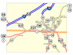
US 11W follows Reedy Creek through the hamlet of Mill Point, where the highway intersects the northern end of SR 394, which heads southeast toward the Sullivan County seat of Blountville. Just west of Bristol, the U.S. Highway meets I-81 at a seven-ramp cloverleaf interchange. The movement from southbound US 11W to northbound I-81 is made via a ramp just south of where I-81 enters Virginia. US 11W continues east as State Street into the city of Bristol, where the highway meets the northern end of SR 126 (Blountville Highway). The U.S. Highway meets the state line at an oblique angle where the highway intersects US 421 (Gate City Highway) and SR 1, which heads east as a solo highway as State Street to its eastern terminus in the Bristol Commercial Historic District. US 11W and US 421 head northeast as Euclid Avenue through the independent city of Bristol. The highways pass Devault Memorial Stadium, home of the Bristol Pirates, and crosses a rail line at grade before US 11W reaches its northern terminus at Commonwealth Avenue. Southbound Commonwealth Avenue carries southbound US 11E, US 19, and US 421. Virginia State Route 381 follows the north–south boulevard through the intersection; the state highway becomes I-381, a spur south from I-81, a short distance to the north. Euclid Avenue continues east as mainline US 11 and US 19.[1]
Major intersections
| State | County | Location | mi[1][2] | km | Destinations | Notes |
|---|---|---|---|---|---|---|
| Tennessee | Knox | Knoxville | 0.00 | 0.00 | Interchange; southern end of SR 1 overlap; US 11E south and US 11W merge into US 11 | |
| Interchange; northbound entrance only | ||||||
| 0.5 | 0.80 | I-40 exit 392 | ||||
| Grainger | Blaine | 15.0 | 24.1 | Eastern terminus of SR 61 | ||
| Rutledge | 29.0 | 46.7 | Northern terminus of SR 92 | |||
| Bean Station | 40.4 | 65.0 | Interchange; southern end of US 25E / SR 32 overlap | |||
| 43.1 | 69.4 | Interchange; northern end of US 25E / SR 32 overlap | ||||
| Hawkins | Mooresburg | 46.9 | 75.5 | Southern terminus of SR 31 | ||
| | 57.1 | 91.9 | Northern terminus of SR 344 | |||
| Rogersville | West Main Street – Downtown Business District | Former US 11W/SR 1 | ||||
| 60.2 | 96.9 | Interchange; Southern end of SR 70 overlap | ||||
| 63.0 | 101.4 | Interchange; Northern end of SR 70 overlap; Western terminus of SR 347 | ||||
| Surgoinsville | 68.3 | 109.9 | Southern terminus of SR 346 | |||
| 74.9 | 120.5 | Southern end of unsigned SR 346 overlap | ||||
| Church Hill | 79.5 | 127.9 | Northern end of unsigned SR 346 overlap | |||
| Hawkins–Sullivan county line | Kingsport | 86.0– 86.2 | 138.4– 138.7 | Bridge over the North Fork Holston River | ||
| Sullivan | 87.9 | 141.5 | I-26 exit 1; western terminus of I-26; southern terminus of unsigned SR 137 | |||
| 88.7 | 142.7 | Interchange | ||||
| 92.2 | 148.4 | Interchange | ||||
| Mill Point | 101.5 | 163.3 | Western terminus of SR 394 | |||
| Bristol | 107.2 | 172.5 | I-81 exit 74 | |||
| 109.4 | 176.1 | Eastern terminus of SR 126 | ||||
| Tennessee–Virginia state line | 110.0 0.00 | 177.0 0.00 | Northern end of SR 1 overlap southern end of US 421 overlap | |||
| Virginia | City of Bristol | 1.12 | 1.80 | Northern end of US 421 overlap; US 11E north and US 11W merge into US 11 | ||
1.000 mi = 1.609 km; 1.000 km = 0.621 mi
| ||||||
References
- Google (2011-08-25). "U.S. Route 11W" (Map). Google Maps. Google. Retrieved 2011-08-25.
- "2009 Traffic Data". Virginia Department of Transportation. 2009. Retrieved 2011-08-25.
- Teague, Slater (September 2, 2018). "Bloody 11W: State investigating deadly section of Hawkins County highway". WJHL News Channel 11. Retrieved May 6, 2020.
- Lakin, Matt (August 26, 2012). "Blood on the asphalt: 11W wreck left 14 people dead". Knoxville News Sentinel. Retrieved June 22, 2020.
- Spears, Joel (June 5, 2015). "Signs commemorate historic State Route 1, U.S. Hwy. 11W". The Rogersville Review. Retrieved July 28, 2020.
In the mid-20th Century its curves earned it the monicker “Bloody 11W” for an excessive number of fatal accidents on the road.
External links
| Wikimedia Commons has media related to U.S. Route 11W. |
| Preceded by Tennessee |
U.S. Route 11 US 11W US 11E |
Succeeded by Virginia |
