Interstate 81 in Tennessee
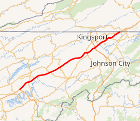
Interstate 81 (I-81) is an 855-mile-long (1,376 km) Interstate Highway stretching from Dandridge, Tennessee, northward to the Thousand Islands Bridge at the Canadian border near Fishers Landing, New York. In Tennessee, I-81 travels 75.66 miles (121.76 km) from its southern terminus at I-40 in Dandridge to the Virginia state line in Bristol. In addition, the route serves the Tri-Cities region of northeast Tennessee, but bypasses most cities that it serves, instead providing access via interchanges with state and federal routes. In Tennessee, I-81 remains in the Ridge and Valley topographic region of the Appalachian Mountains, and runs in a more northeast-southwest direction.
| ||||
|---|---|---|---|---|

I-81 highlighted in red | ||||
| Route information | ||||
| Maintained by TDOT | ||||
| Length | 75.66 mi[1] (121.76 km) | |||
| Major junctions | ||||
| South end | ||||
| ||||
| North end | ||||
| Location | ||||
| Counties | Jefferson, Hamblen, Greene, Washington, Sullivan | |||
| Highway system | ||||
| ||||
Route description

Interstate 81 begins in at an interchange with Interstate 40 near Dandridge in Jefferson County. About 4 miles (6.4 km) later is an interchange with SR 341, which connects to SR 66 a short distance later, providing access to Morristown. 4 miles (6.4 km) later, I-81 crosses into Hamblen County and meets U.S. Route 25E south of Morristown. Continuing through mostly rural terrain, I-81 has an interchange with SR 160, the final Morristown exit, about 4 miles (6.4 km) later. About 9 miles (14 km) later, the interstate crosses over a ridge and into Greene County. About 5 miles (8.0 km) beyond this point is an interchange with US 11E, which provides access to Greeneville to the southeast and Bull's Gap to the northwest. Continuing through a predominantly rural and agricultural area, I-81 reaches SR 70, which connects to Greeneville to the south and Rogersville to the north. Beyond this point, the interstate remains in a predominantly rural and agricultural area, and begins a slight uphill climb, with the northbound lanes utilizing a truck climbing lane for about 1.5 miles (2.4 km) near the community of Jearoldstown, where the route also shifts slightly to the northeast. A few miles later, I-81 shifts sharply east and crosses into Washington County. Less than a mile later is an interchange with SR 93, which provides access to Jonesborough to the south and Fall Branch to the north. I-81 then turns northeast again, and about 3 miles (4.8 km) later enters Sullivan County. Entering a semi-urbanized part of the Tri-Cities area, I-81 connects to I-26 and US 23 in a cloverleaf interchange about 3 miles (4.8 km) later. This route provides access to Kingsport to the north and Johnson City to the south. A little over two miles later is an interchange with SR 36, another major connector between these two cities. I-81 then crosses the Holston River about a mile later, and begins another slight uphill climb, once again gaining a truck climbing lane on the northbound lanes. About 3 miles (4.8 km) later the truck lane terminates at an interchange with SR 357, a connector to the Tri-Cities Regional Airport, and the route continues through the semi urban area, briefly shifting eastward and crossing a ridge about 4 miles (6.4 km) later. Shifting northeastwardly again, I-81 has an interchange with SR 394 near the city of Blountville. Beyond this exit, the route crosses a slight upgrade once again, before reaching a relatively flat stretch again. About 5 miles (8.0 km) later, I-81 reaches Bristol and widens to six lanes. The route then has a cloverleaf interchange with US 11W, before crossing into Virginia 1 mile (1.6 km) later.
History
One of the first sections to be opened to traffic was the 1 mile (1.6 km) segment between US 11W and the Virginia state line, opened by the early 1960s. [2] The segment between the southern terminus with I-40 and US 25E in Hamblen County was completed in late 1966.[3] Like most of the interstates in Tennessee, priority was generally given to completing sections in Middle and West Tennessee over East Tennessee, and as a result, most of I-81 in Tennessee was not constructed until after the late 1960s.[2] The contracts for most sections of the route were awarded in 1969 and 1970.[4] On December 20, 1974, two lanes of the final section in Tennessee, the 43 miles (69 km) section located between US 11E near Morristown and SR 126 near Blountville, were opened to traffic,[5][6] and the section was completed on August 27, 1975.[7]
Exit list
| County | Location | mi | km | Exit | Destinations | Notes |
|---|---|---|---|---|---|---|
| Jefferson | Dandridge | 0.00 | 0.00 | 1 | Southern terminus; I-40 exit 421; signed as left exit 1A (east) & 1B (west). | |
| White Pine | 4.4 | 7.1 | 4 | |||
| Hamblen | Morristown | 8.6 | 13.8 | 8 | ||
| 12.4 | 20.0 | 12 | ||||
| | 15.3 | 24.6 | 15 | |||
| Greene | Mosheim | 23.1 | 37.2 | 23 | Access to Tusculum College | |
| | 30.2 | 48.6 | 30 | |||
| Baileyton | 36.2 | 58.3 | 36 | |||
| Jearoldstown | 43.9 | 70.7 | 44 | Jearoldstown Road | ||
| Washington | Fall Branch | 50.5 | 81.3 | 50 | ||
| Sullivan | Kingsport | 56.1 | 90.3 | 56 | Tri-Cities Crossing | |
| 57.7 | 92.9 | 57 | Signed as Exits 57A (east) & 57B (west), I-26 exits 8A-B; former I-181 south | |||
| 59.4 | 95.6 | 59 | ||||
| 63.5 | 102.2 | 63 | Also access to Northeast State Community College | |||
| 66.1 | 106.4 | 66 | ||||
| Blountville | 69.6 | 112.0 | 69 | Access to Bristol Motor Speedway | ||
| Bristol | 74.8 | 120.4 | 74 | Signed as Exits 74A (north) & 74B (south) | ||
| 75.66 | 121.76 | Virginia state line | ||||
| 1.000 mi = 1.609 km; 1.000 km = 0.621 mi | ||||||
Auxiliary routes
I-181 in Johnson City and Kingsport is a former spur route that was renumbered as I-26 by March 2007.
See also

References
- 2007 Rand McNally Atlas
- "Table 1: Main Routes of the Eisenhower National System of Interstate and Defense Highways". Route Log and Finder List. Federal Highway Administration. Retrieved October 4, 2014.
- "Where Do We Stand On The Interstate?". Kingsport Times-News. May 2, 1965. p. 8 – via Newspapers.com.
- "Interstate highways to be opened". Johnson City Press-Chronicle. United Press International. October 22, 1966. p. 24. Retrieved April 30, 2020 – via Newspapers.com.
- "81 Moving Along: Chamber". Kingsport Times-News. May 2, 1965. p. 5. Retrieved June 18, 2018 – via Newspapers.com.
- Samples, Henry (December 20, 1974). "Dunn opens interstate from Blountville to Greeneville". Johnson City Press-Chronicle. Johnson City, Tennessee. p. 1. Retrieved April 30, 2020 – via Newspapers.com.
- "East Tennessee's Christmas Present". Kingsport Times-News. December 10, 1974. p. 11. Retrieved June 18, 2018 – via Newspapers.com.
- "All four lanes of Interstate 81 to be opened today". Johnson City Press-Chronicle. August 27, 1975. p. 16. Retrieved December 8, 2019 – via Newspapers.com.
External links

| Previous state: Terminus |
Tennessee | Next state: Virginia |
