Cherokee Lake
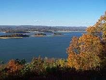
Cherokee Lake, also known as Cherokee Reservoir, is a reservoir in Tennessee formed by the impoundment of the Holston River behind Cherokee Dam.
| Cherokee Lake | |
|---|---|
| Cherokee Reservoir | |
 | |
| Location | Grainger / Hamblen / Jefferson / Hawkins counties, Tennessee, United States |
| Coordinates | 36.2149°N 83.4350°W |
| Type | Reservoir |
| Primary inflows | Holston River |
| Primary outflows | Holston River |
| Basin countries | United States |
| Managing agency | Tennessee Valley Authority |
| Surface area | 28,780 acres (11,650 ha) |
| Average depth | 30 ft (9.1 m) |
| Water volume | 749,400 acre⋅ft (924,400,000 m3) |
| Shore length1 | 400 mi (640 km) |
| Settlements | Bean Station, Morristown, Jefferson City |
| Website | www |
| 1 Shore length is not a well-defined measure. | |
Hydrology
The reservoir has a surface area of about 28,780 acres (11,650 ha), a flood-storage capacity of 749,406 acre feet (924,379,000 m3), and nearly 400 miles (640 km) of shoreline.[1] In a normal year, the lake water level fluctuates over a range of about 27 feet (8.2 m).[1]
In order to maintain dissolved oxygen concentrations in the river below the dam at levels that will support aquatic life, perforated hoses suspended above the bottom of Cherokee Reservoir are used to inject oxygen into the reservoir water and devices which resemble large underwater fans located just above the dam are used to push warm oxygenated water downward to the depths where water is released for hydroelectric generation.[1][2]
Natural history
Black bass, sauger, walleye, crappie, various sunfish, and the usual rough-fish species, are often seen in the reservoir.[3]
History
The reservoir was formed after the construction of Cherokee Dam near Grainger-Jefferson border. The dam, operated by the Tennessee Valley Authority, is used for hydroelectric generation and flood control. The dam was built on a crash schedule; construction started August 1, 1940, and was completed on December 5, 1941.[1]
The dam and the reservoir were named after the Native American tribe of the same name by the TVA, as before the Holston's impoundment, the area was once inhabited by the tribe. The Great Indian Warpath, once used by pioneer Daniel Boone, lies in the basin of the reservoir.[3]
Economy
Public access areas, Panther Creek State Park and other public parks, commercial boat docks, resorts, RV and tent campgrounds, and a state wildlife management area on the shores of the lake attract extensive recreational use.[1]
Since the lake has a greater fish density than most reservoirs maintained by the TVA, it has become one of the most popular for anglers in the East Tennessee region.[4]
The lake is home to a sailing club and regattas are hosted seasonally on its waters.[4]
References
- Cherokee Reservoir factsheet, Tennessee Valley Authority
- Water Quality Improvements at Tributary Dams: Cherokee Dam Archived October 5, 2008, at the Wayback Machine, Tennessee Valley Authority
- "Cherokee". Tennessee Valley Authority. Retrieved August 7, 2020.
- "Cherokee Lake in East Tennessee". 9 Lakes of East Tennessee. Retrieved August 7, 2020.
External links
| Authority control |
|
|---|