Taboga District
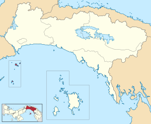
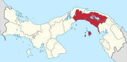
Taboga District (Spanish pronunciation: [taˈβoɣa]) is a district (distrito) of Panamá Province in Panama. The population according to the 2000 census was 1,402;[2] the latest official estimate (for 2019) is 1,387.[3] The district covers a total area of 12.1 km2 (4.7 sq mi). The capital lies at the town of Taboga.[2]
Taboga District | |
|---|---|
 | |
 Taboga District Location of the district capital in Panama | |
| Coordinates: 8°48′N 79°33′W | |
| Country | |
| Province | Panamá Province |
| Capital | Taboga |
| Area | |
| • Total | 12.1 km2 (4.7 sq mi) |
| Population (2019) | |
| • Total | 1,387 |
| • Density | 110/km2 (300/sq mi) |
| official estimate[1] | |
| Time zone | UTC-5 (ETZ) |
Taboga is an island district that includes the islands of Taboga, Taboguilla, Otoque, Urabá, Melones, Chamá, and Estivá. Taboga itself is 8 miles (13 km) long and is 12 miles (19 km) away from the mainland.
It was the home of Pizzaro, where he built boats for his conquest of the Incas in 1539.
Administrative divisions
Taboga District is divided administratively into the following corregimientos:
- Taboga (capital)
- Otoque Occidente
- Otoque Oriente
gollark: Somehow.
gollark: Idea: a chess roguelike using hyperbolic geometry.
gollark: ++delete chess
gollark: +=delete chess
gollark: I should make some sort of Emu War Core for headless emu war.
References
- Instituto Nacional de Estadística y Censo, Panama.
- "Districts of Panama". Statoids. Retrieved April 12, 2009.
- Instituto Nacional de Estadística y Censo, Panama.
This article is issued from Wikipedia. The text is licensed under Creative Commons - Attribution - Sharealike. Additional terms may apply for the media files.
