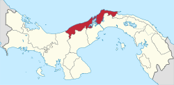
Donoso District
Donoso District is a district (distrito) of Colón Province in Panama. The population according to the 2000 census was 9,671;[2] the latest official estimate (for 2019) is 14,798.[3] The district, while lies along the Caribbean coast in the west of the province, covers a total area of 1,826 km². The capital lies at the town of Miguel de la Borda.[2]
Donoso District | |
|---|---|
.svg.png) | |
 Donoso District Location of the district capital in Panama | |
| Coordinates: 9°9′N 80°19′W | |
| Country | |
| Province | Colón Province |
| Capital | Miguel de la Borda |
| Area | |
| • Total | 705 sq mi (1,826 km2) |
| Population (2019) | |
| • Total | 14,798 |
| • Density | 21/sq mi (8.1/km2) |
| official estimate[1] | |
| Time zone | UTC-5 (ETZ) |
Administrative divisions
Donoso District is divided administratively into the following corregimientos:
- Miguel de la Borda (capital)
- Coclé del Norte
- El Guásimo
- Gobea
- Río Indio
- San José del Genera
gollark: The n-1 bottles line is proving surprisingly hard to get right.
gollark: I see.
gollark: Ah, I see.
gollark: Also, what does "no 99 is allowed" mean?
gollark: d n asfd?
References
- Instituto Nacional de Estadística y Censo, Panama.
- "Districts of Panama". Statoids. Retrieved April 11, 2009.
- Instituto Nacional de Estadística y Censo, Panama.
This article is issued from Wikipedia. The text is licensed under Creative Commons - Attribution - Sharealike. Additional terms may apply for the media files.