Arraiján District
Arraiján District is a district (distrito) of West Panamá Province in Panama. The territory lies west of the Panama Canal bordering Panama City. The population according to the 2000 census was 149,918;[2] the latest official estimate (for 2019) is 296,188,[3] with many suburban communities for commuting workers of Panama City. The district covers a total area of 418 km². The district seat is Arraiján city.[2]
Arraiján District | |
|---|---|
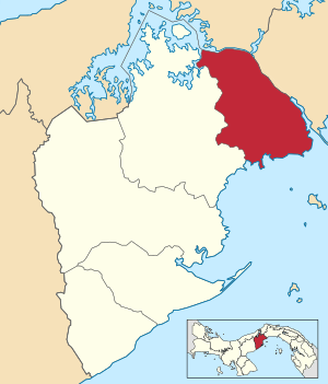 | |
 Arraiján District Location of the district capital in Panama | |
| Coordinates: 8°57′N 79°39′W | |
| Country | |
| Province | West Panamá Province |
| Capital | Arraiján |
| Area | |
| • Total | 161 sq mi (418 km2) |
| Population (2019) | |
| • Total | 296,188 |
| official estimate[1] | |
| Time zone | UTC-5 (ETZ) |
Administrative divisions
Arraiján District is divided administratively into the following corregimientos:
- Arraiján (capital)
- Juan Demóstenes Arosemena
- Nuevo Emperador
- Santa Clara
- Veracruz
- Vista Alegre
- Burunga
- Cerro Silvestre
Education
The Lycée français Paul Gauguin de Panama, a French international school, is in Panama Pacifico in Veracruz.[4]
gollark: Type "bash" to enter the "bash" shell.
gollark: That is due to the "dash" shell.
gollark: Try logging in on a text terminal (ctrl+alt+F1) instead.
gollark: You can probably log in as root and manually useradd/adduser (I never remember which way round that goes).
gollark: I blame DNS, personally.
References
- Instituto Nacional de Estadística y Censo, Panama.
- "Districts of Panama". Statoids. Retrieved April 12, 2009.
- Instituto Nacional de Estadística y Censo, Panama.
- "Nuestra Ubicación Archived 2015-04-02 at the Wayback Machine"/"Où sommes nous? Archived 2015-04-02 at the Wayback Machine" Lycée français Paul Gauguin de Panama. Retrieved on 15 March 2015. "Dirección: Edificio 810, Ave. Ingeniero Way, Panamá Pacífico"
Capital: La Chorrera | ||
| Arraiján District | 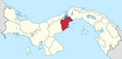 | |
| Capira District | ||
| Chame District | ||
| La Chorrera District | ||
| San Carlos District | ||
This article is issued from Wikipedia. The text is licensed under Creative Commons - Attribution - Sharealike. Additional terms may apply for the media files.