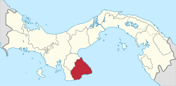
Los Santos District
Los Santos District is a district (distrito) of Los Santos Province in Panama. The population according to the 2000 census was 23,828.[1]The district covers a total area of 429 km². The capital lies at the city of La Villa de los Santos.[1]
Los Santos District | |
|---|---|
 La Villa de los Santos | |
 Flag  Seal | |
 | |
 Los Santos District Location of the district capital in Panama | |
| Coordinates: 7°50′N 80°20′W | |
| Country | |
| Province | Los Santos Province |
| Capital | Las Tablas |
| Area | |
| • Total | 166 sq mi (429 km2) |
| Population (2000) | |
| • Total | 23,828 |
| Time zone | UTC-5 (ETZ) |
Administrative divisions
Los Santos District is divided administratively into the following corregimientos:
- La Villa de los Santos (capital)
- El Guásimo
- La Colorada
- La Espigadilla
- Las Cruces
- Las Guabas
- Los Angeles
- Los Olivos
- Llano Largo
- Sabanagrande
- Santa Ana
- Tres Quebradas
- Villa Lourdes
- Agua Buena
- El Ejido
gollark: It sort of kind of inspired much of GTech™ operation.
gollark: You've read UNSONG? Excellent.
gollark: While the majority of years after 2446 were cancelled due to cost overruns, 2446.5 is still available, as are many lower-cost alternate years.
gollark: This is actually false.
gollark: February 30th, for instance, is generally used for routine maintenance of time systems.
References
- "Districts of Panama". Statoids. Retrieved April 12, 2009.
This article is issued from Wikipedia. The text is licensed under Creative Commons - Attribution - Sharealike. Additional terms may apply for the media files.