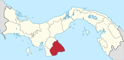
Las Tablas District
Las Tablas District is a district (distrito) of Los Santos Province in Panama. The population according to the 2000 census was 24,298.[1] The district covers a total area of 698 square kilometres (269 sq mi). The capital lies at the city of Las Tablas.[1]
Las Tablas District | |
|---|---|
 | |
 Coat of arms | |
 | |
 Las Tablas District Location of the district capital in Panama | |
| Coordinates: 7°46′N 80°17′W | |
| Country | |
| Province | Los Santos Province |
| Capital | Las Tablas |
| Area | |
| • Total | 269 sq mi (698 km2) |
| Population (2000) | |
| • Total | 24,298 |
| Time zone | UTC-5 (ETZ) |
Administrative divisions
Las Tablas District is divided administratively into the following corregimientos:
gollark: I would simply simulate a "hurdy-gurdy" if desired.
gollark: Due to PIERB decree, ABR apiotrackers™ are quite low-resolution.
gollark: ?
gollark: Oh, did qh4os cease to exist
gollark: At the end of the timestep.
References
- "Districts of Panama". Statoids. Retrieved April 12, 2009.
This article is issued from Wikipedia. The text is licensed under Creative Commons - Attribution - Sharealike. Additional terms may apply for the media files.