La Chorrera District
La Chorrera District is a district (distrito) of Panamá Oeste Province in Panama. The population according to the 2000 census was 124,656;[2] the latest official estimate (2019) is 199,708.[3] The district covers a total area of 770 km². The capital lies at the city of La Chorrera.[2]
La Chorrera District | |
|---|---|
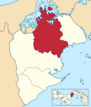 | |
 La Chorrera District Location of the district capital in Panama | |
| Coordinates: 8°52′49″N 79°47′0″W | |
| Country | |
| Province | Panamá Oeste Province |
| Capital | La Chorrera |
| Area | |
| • Total | 300 sq mi (770 km2) |
| Population (2019) | |
| • Total | 199,708 |
| official estimate[1] | |
| Time zone | UTC-5 (ETZ) |
Administrative divisions
The district is divided administratively into the following corregimientos:
- La Chorrera
- Barrio Balboa
- Barrio Colón
- Amador
- Arosemena
- El Arado
- El Coco
- Feuillet
- Guadalupe
- Herrera
- Hurtado
- Iturralde
- La Represa
- Los Díaz
- Mendoza
- Obaldía
- Playa Leona
- Puerto Caimito
- Santa Rita
gollark: https://images-ext-1.discordapp.net/external/pRhCVGeVxDB6XqapPAGHKWIxvU6-ThzU4XPnq7Gvh1s/%3Fwidth%3D594%26height%3D654/https/media.discordapp.net/attachments/823603493989515316/888539564308844617/E_QDrxcXMAQ6ft3.png?width=566&height=623
gollark: Just use a calculator in all cases.
gollark: Yes.
gollark: ↑ useful haskell guide
gollark: https://pbs.twimg.com/media/EdgRZ_TU0AMavDl?format=png&name=medium
References
- Instituto Nacional de Estadística y Censo, Panama.
- "Districts of Panama". Statoids. Retrieved April 12, 2009.
- Instituto Nacional de Estadística y Censo, Panama.
Capital: La Chorrera | ||
| Arraiján District | 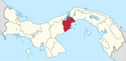 | |
| Capira District | ||
| Chame District | ||
| La Chorrera District | ||
| San Carlos District | ||
This article is issued from Wikipedia. The text is licensed under Creative Commons - Attribution - Sharealike. Additional terms may apply for the media files.