Macaracas District
Macaracas District is a district (distrito) of Los Santos Province in Panama. The population according to the 2000 census was 9,137.[1] The district covers a total area of 504 km². The capital lies at the city of Macaracas.[1]
Macaracas District | |
|---|---|
 Coat of arms | |
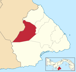 | |
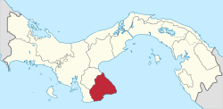
 Macaracas District Location of the district capital in Panama | |
| Coordinates: 7°43′48″N 80°32′24″W | |
| Country | |
| Province | Los Santos Province |
| Capital | Macaracas |
| Area | |
| • Total | 195 sq mi (504 km2) |
| Population (2000) | |
| • Total | 9,137 |
| Time zone | UTC-5 (ETZ) |
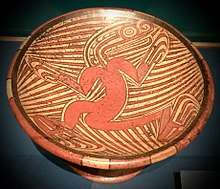
A Macaracas style Coclé bowl, from around 800-1000 AD. The background design is stingray spines.
The Macaracas style of Gran Coclé Precolumbian pottery was named for archaeological sites found in this District.
Administrative divisions
Macaracas District is divided administratively into the following corregimientos:
- Macaracas (capital)
- Bahía Honda
- Bajos de Guera
- Corozal
- Chupa
- El Cedro
- Espino Amarillo
- La Mesa
- Llano de Piedra
- Las Palmas
- Mogollón
...
gollark: It creates inequality basically as a built-in thing.
gollark: I'd like to have them be assigned randomly, but that's not really possible.
gollark: The correct way is to have all new coins be manually issued by me.
gollark: Proof of stake bad
gollark: ++delete PHP hypertext preprocessor
References
- "Districts of Panama". Statoids. Retrieved April 12, 2009.
This article is issued from Wikipedia. The text is licensed under Creative Commons - Attribution - Sharealike. Additional terms may apply for the media files.