Shopian district
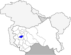
Shopian or Shupiyan is a hill district with its administrative division in Shopian, located in the Indian union territory of Jammu and Kashmir,[2] since it is situated on the historical road commonly known as Mughal Road, most of its area is occupied by forests. Shopian district comes under the Pir Panjal Range which makes it very cold in winter.[3] After partition of India, it was a tehsil of Pulwama district. In March, 2007, the district status was granted by the Government of India.[4][5] Shopian is known worldwide for its fresh fruits like apricots, peaches, pears, berries, cherries, and most importantly for apples. Shopian is also known as the 'Apple Town' of Kashmir.
Shopian district | |
|---|---|
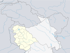
 Location in Jammu and Kashmir, India | |
 Shopian district Location in Jammu and Kashmir, India  Shopian district Shopian district (India) | |
| Coordinates: 33.72°N 74.83°E[1] | |
| Country | |
| Union Territory | Jammu and Kashmir |
| Headquarters | Shopian |
| Area | |
| • Total | 612.9 km2 (236.6 sq mi) |
| Area rank | 537th in India & 17th in Jammu & Kashmir |
| Population (Census 2011) | |
| • Total | 266,215 |
| • Density | 430/km2 (1,100/sq mi) |
| Languages | |
| Time zone | UTC+5:30 (IST) |
| Vehicle registration | JK-22 |
| Website | http://shopian.nic.in |
Demographics
According to the 2011 census, the Shopian district has a population of 266,215.[6] This gives the Shopian district a ranking of 577th in India (out of a total of 640).[6] The district has a population density of 852 inhabitants per square kilometre (2,210/sq mi) .[6] Its population growth rate over the 2001–2011 decade was 25.85%.[6] Shopian has a sex ratio of 951 females for every 1,000 males[6] (this varies with religion), and a literacy rate of 62.49%.[6]
Shopian district: mother-tongue of population, according to the 2011 Census.[8]
| Shopian (Shupiyan) district: religion, gender ratio, and % urban of population, according to the 2011 Census.[7] | |||||||||
|---|---|---|---|---|---|---|---|---|---|
| Hindu | Muslim | Christian | Sikh | Buddhist | Jain | Other | Not stated | Total | |
| Total | 3,116 | 262,263 | 429 | 178 | 6 | 1 | 6 | 216 | 266,215 |
| 1.17% | 98.52% | 0.16% | 0.07% | 0.00% | 0.00% | 0.00% | 0.08% | 100.00% | |
| Male | 2,777 | 133,233 | 229 | 100 | 2 | 1 | 3 | 135 | 136,480 |
| Female | 339 | 129,030 | 200 | 78 | 4 | 0 | 3 | 81 | 129,735 |
| Gender ratio (% female) | 10.9% | 49.2% | 46.6% | 43.8% | 66.7% | 0.0% | 50.0% | 37.5% | 48.7% |
| Sex ratio (no. of females per 1,000 males) |
122 | 968 | – | – | – | – | – | – | 951 |
| Urban | 2,146 | 14,060 | 67 | 56 | 2 | 0 | 0 | 29 | 16,360 |
| Rural | 970 | 248,203 | 362 | 122 | 4 | 1 | 6 | 187 | 249,855 |
| % Urban | 68.9% | 5.4% | 15.6% | 31.5% | 33.3% | 0.0% | 0.0% | 13.4% | 6.1% |
| Shopian district: mother-tongue of population, according to the 2011 Census.[8] | |||
|---|---|---|---|
| Mother tongue code | Mother tongue | People | Percentage |
| 001002 | Assamese | 45 | 0.02% |
| 002007 | Bengali | 191 | 0.07% |
| 004001 | Dogri | 243 | 0.09% |
| 005018 | Gujarati | 38 | 0.01% |
| 006102 | Bhojpuri | 34 | 0.01% |
| 006207 | Gojri/Gujjari/Gujar | 23,425 | 8.80% |
| 006240 | Hindi | 1,425 | 0.54% |
| 006439 | Pahari | 4,749 | 1.78% |
| 006489 | Rajasthani | 46 | 0.02% |
| 007016 | Kannada | 125 | 0.05% |
| 008005 | Kashmiri | 234,253 | 87.99% |
| 011016 | Malayalam | 97 | 0.04% |
| 013071 | Marathi | 71 | 0.03% |
| 014011 | Nepali | 36 | 0.01% |
| 015043 | Odia | 31 | 0.01% |
| 016038 | Punjabi | 217 | 0.08% |
| 020027 | Tamil | 185 | 0.07% |
| 021046 | Telugu | 150 | 0.06% |
| 022015 | Urdu | 162 | 0.06% |
| 024001 | Afghani/Kabuli/Pashto | 506 | 0.19% |
| 053005 | Gujari | 116 | 0.04% |
| – | Others | 70 | 0.03% |
| Total | 266,215 | 100.00% | |
Healthcare
The district has a number of hospitals and healthcare facilities, some of which include its adjoining areas they are: District Hospital, Shopian, Sub District Hospital Zainapora, Sub District Hospital Keller , NTPHC Ramnagri, PHC Herman, PHC Pinjura PHC DK Pora, PHC Vehil, PHC Sedow.PHC NadiGam.[9]
Places of interest
Shopian district has many places with tourism potential: Arshi Pora Lahanthour, Sedow, Hirpora Wildlife Sanctuary, Dubijan - 6 km from Heerpora Village; Peer Marg/Peer Gali - 20 km away from Heerpora on the historical Mughal Road; Lake Nandansar - 2 km away from the Peer Ki Gali; Hash Wang Bagam Pather, Sok Saray, and Mughal Saray at Jajinar. The Jamia Masjid in Shopian is one of the famous historical monuments built during the Mughal reign resembling that of jamia Masjid Srinagar. The Aasar-i-Sharief Dargah at Pinjura, attracts thousands of devotees on the occasion of Eid-i-Milad-un- Nabi and Shab-i-Mehraj. Darul Uloom Islamia Pinjura where large people gather to seek (spiritual and moral) knowledge and propagate to others.
On the outskirts of Shopian town near Nagbal area, there is a Siva temple called Kapalmochan Mandir with three natural springs and a unique Shivling with small Rudraksh shaped knots spread all over it.
Transport
The major roads connecting Shopian with neighbouring districts are:
- Shopian-Pulwama-Srinagar Road
- Shopian-Anantnag Via Chitragam
- Shopian -Anantnag via Kaider
- Shopian Anantnag Via Kulgam khudwani Wanpoh khanabal
- Shopian-Rajouri-Poonch via Mughal Road
- Shopian-Zawoora-Keller
- Shopian-Sedow-Aharbal
- Shopian-Hirpora
- Shopian-Bijbehara via Malik Gund Imamsahib,
- Shopian-Pinjoor
- Shopian-Zainapora( Babapora)- Frisal- khudwani
- Shopian-Zainapora( Babapora)- wachi - Sangam
- Shopian to Kulgam kachdoora, sehpora Mohan Pora or Okay
- Shopian to Reshnagri via Narwaw, Saidpora
- Shopian to Nehama via Vehil Nowgam, Kanjiullar
- Shopian to Ramnagri via Narwaw, Saidpora, Amshipora.
- Shopian to Kangiullar via Ramnagri and Gadiporahir
- Shopian to Kheer Bhawani at Mamzam via Ramnagri, Kanjiuller Nihama
- Shopian to Aharbal via Ramnagri, Gadipora and Nihama
- Shopian to Zawoora via Rambiara.
- Shopian to Shadab Karewa Via Zowoora.
- Shopian to Narapora, keller via Zawoora
- Shopain to Aharbal via Saidow
- Shopian Arshi pora road to link Via Herman Kadder Road
- Shopian to Manzimpara via Kundalan.
- Shopian to Anantnag via Manihall and Yaripora
- Shopian to Toolihalan
- Shopian to Aharbal via Ramnagri, Reshnagri,Bridge Completed in Last year.
Villages to Visit
- Sedheve
The location code or village code of Sedheve village is 003497.Sedheve is a very beautiful village of shopian district. It is best known for its natural beauty viz, V Mountain (V shaped mountain), orchards, grasslands and bounty forests.The total geographical area of village is 413.2 hectares. Sedheve has a total population of 3,819 peoples. There are about 609 houses in Sedheve village. Shopiyan is nearest town to Sedheve which is approximately 8 km away.
See also
References
- Falling Rain Genomics, Inc - Shupiyan
- "Shupiyan District : Census 2011-2018 data". census2011.co.in. 2011 Census of India.
- "J&Ks Shopian dist to get new tourism development authority". indiatoday.in. India Today.
- "Granted district status 11 years ago, Shopian still craves for facilities". greaterkashmir.com. Greater Kashmir.
- "Brief Industrial Profile of Shopian District" (PDF). dcmsme.gov.in. Development Commissioner Ministry of Micro, Small & Medium Enterprises.
- "District Census 2011". Census2011.co.in. 2011. Retrieved 30 September 2011.
- C-1 Population By Religious Community – Jammu & Kashmir (Report). Office of the Registrar General & Census Commissioner, India. Retrieved 28 July 2020.
- C-16 Population By Mother Tongue – Jammu & Kashmir (Report). Office of the Registrar General & Census Commissioner, India. Retrieved 18 July 2020.
- "Health setup in District Shopian".