Lolab Valley
The Lolab Valley is a Himalayan[2] valley located in Jammu and Kashmir, India. The entrance to the valley lies 9 km (5.6 mi) north of Kupwara town, and the centre of the valley lies 114 km (71 mi) northwest of Srinagar, the capital of Jammu and Kashmir. It is an oval-shaped valley 15 miles (24 km) long with an average width of 2 miles (3.2 km).
| Lolab Valley | |
|---|---|
Lolab Valley | |
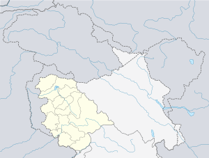
 Lolab Valley Location in Jammu and Kashmir, India  Lolab Valley Lolab Valley (India) | |
| Floor elevation | 5,564 ft (1,696 m) |
| Length | 15 mi (24 km) |
| Width | 2 mi (3.2 km) |
| Geography | |
| Country | |
| State | Jammu and Kashmir |
| District | Kupwara |
| Population center | Sogam Lolab[1] |
| Borders on | Neelum Valley (North) Kashmir Valley (South) |
| Coordinates | 34°30′N 74°22′E |
| River | Lahwal River |
Geography
The Lolab Valley is situated within the jurisdiction of Sogam Lolab, a block of Kupwara. It is bordered by the Kashmir Valley to the south and the Neelum Valley to the north, and is separated by Nagmarg meadows from Bandipore[3] to the east. It is formed by the flow of Lahwal River, which flows from east to west. The Lolab Valley is home 9 many ancient springs, and is covered with dense forests of pine and fir.[4] Fruit trees such as apple, cherry, peach, apricot and walnut are common in the valley, which is known as "the fruit bowl of Jammu and Kashmir".[5] The valley has several natural landmarks and tourist spots, such as the caves of Kalaroos. The main villages in the Lolab Valley are Putushai, Diver, Khumriyal, Sogam, Lalpora,Cherkoot,Kalaroos,Wavoora, Warnow, Michal, Takipora, Goose etc.
Ecology
Like other valleys in the region, Lolab Valley is also home to many Himalayan wild animals, which include Himalayan black bear, Himalayan brown bear, snow leopard, ibex, markhor, hangul and musk deer.[6] Lolab Valley is adjacent to Neelum Valley, and separated by the Line of Control.[7] The Valley has seen many armed combats,[8][9] which has resulted in the displacement of many wild animals.
Access
The Lolab Valley is well connected by road to Srinagar, the capital of Jammu and Kashmir, and Srinagar Airport. A bus takes three hours to cover a distance of 114 km (71 mi) and leads through the towns of Sopore and Kupwara. An under-construction road from Bandipora to Lolab via Nagmarg Meadows will cut short the Srinagar-to-Lolab distance by 30 kilometers. In Lolab Valley, there are a few tourist huts and many camping sites. It has the potential to become one of the best tourist destinations in Kashmir.
Tourism
Travelers visiting Lolab sometimes visit the resting place of the saint Kashyap reshi, which is located at a distance of 1 km from village Lalpora. A spring called Lavnag can be found nearby. The spring is three feet deep and has crystal clear water. Gauri spring is another major spring in the area. Due lack of intervention by government the place has very poor flow of tourists which keeps it potential for tourism still unexplored. This place still manages to be one of the top most camping sites in Kashmir.
Some tourist attractions in the valley include Nagmarg Camping Site Diver Anderbugh, Satbaran Kalaroos, Chandigam, Warnav, Machil and Kariwan Green Meadows Diver.
Poem
Lolab Valley was once visited by one of the greatest Urdu poets of all time, Dr. Sir Muhammad Iqbal and wrote a poem, O Valley of Lolab! in the honour of Lolab's natural environment which starts with the stanza:
پانی ترے چشموں کا تڑپتا ہوا سیماب
مرغانِ سحَرتیری فضاؤں میں ہیں بیتاب
اے وادیِ لولاب
Your springs and lakes with water pulsating and quivering like quicksilver,
the morning birds fluttering about the sky, agitated and in turmoil,
O Valley of Lolab!
گر صاحبِ ہنگامہ نہ ہو منبر ومحراب
دیں بندہٌ مومن کے لیے موت ہے یا خواب
اےوادیِ لولاب
When the pulpit and the niche cease to re‐create Resurrections,
faith then is dead or a mere dream, for thee, me and for all.
O Valley of Lolab!
Notable people
See also
References
- "Sogam page on Fallingrain". Fallingrain Genomics. Retrieved 3 July 2012.
- S.A. Qazi (2005). Systematic Geography of Jammu and Kashmir. APH Publishing. p. 16–. ISBN 978-8176487863.
- John Murray, 1906 (1906). Handbook to India, Burma, and Ceylon. John Murray. p. 253–. ISBN 978-8178350172.
- "Loalab Valley on Ikashmir". ikashmir.net. Retrieved 23 June 2012.
- "Fruit bowl of J&K". india9.com. Retrieved 3 July 2012.
- Charles Ellison Bates (1980). A gazetteer of Kashmír and the adjacent districts of Kishtwar, Badrawár, Jamu, Naoshera, Punch, and the valley of the Kishen Gang. Light & Life Publishers. p. 26–.
- India Today Volume 25. Thomson Living Media India Ltd., 2000. 2000. pp. 53, 54–. ISBN 978-0674018174.
- Outlook. Volume 46, Issues 39-47. Hathway Investments Pvt Ltd. 2006. p. 162–.
- Sumantra Bose (2005). Kashmir: Roots of Conflict, Paths to Peace. Harvard University Press. p. 282. ISBN 978-0674018174.