Nova Scotia Highway 101
Highway 101 is an east-west highway in Nova Scotia that runs from Bedford to Yarmouth.[1][3]
| ||||
|---|---|---|---|---|
| Harvest Highway | ||||
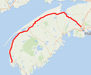
Highway 101 highlighted in red | ||||
| Route information | ||||
| Maintained by Nova Scotia Department of Transportation and Infrastructure Renewal | ||||
| Length | 308.5 km[1][2] (191.7 mi) | |||
| Existed | 1962–present | |||
| Major junctions | ||||
| East end | ||||
| West end | ||||
| Highway system | ||||
| Provincial highways in Nova Scotia 100-series
| ||||

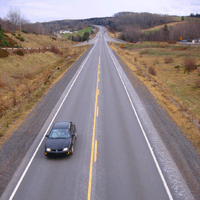
The highway follows a 310 km (190 mi) route along the southern coast of the Bay of Fundy through the Annapolis Valley, the largest agricultural district in the province. Between its western terminus at Yarmouth to Weymouth, the highway is 2-lane controlled access. Between Weymouth and Digby, the highway reverts to a 2-lane local road. From Digby to Grand Pre, the highway is 2-lane controlled access. From the Gaspereau River crossing near Grand Pre to 3 km west of Exit 6 (Falmouth) the highway is a 4-lane expressway. Heading east the highway is 2-lane controlled access until Exit 5 (Trunk 14). From Three Mile Plains to its eastern terminus at Bedford, the highway is a 4-lane expressway. Some of the 2-lane controlled access sections of the highway are 3 or 4 lanes, with the addition of passing lanes. One section of the 4-lane expressway near Hantsport is a short 5-lane (3 lanes westbound) section for about 2 km due to previous road configuration for a passing lane due to a steep hill.[1] Similar to Highway 103, kilometer markers increase run west-to-east, increasing from Yarmouth to Bedford; however, exit numbers run east-to-west, increasing from Bedford to Yarmouth.
The provincial government named the highway the Harvest Highway on 7 December 2008 to recognize the important contributions of farmers in Nova Scotia.[4]
History
The highway was developed in non-contiguous sections with the first parts, between Bedford, Windsor and Avonport, built in the 1960s, followed by parts through the Annapolis Valley, Digby and Yarmouth counties in the 1970s–1990s. The highway was built to provide a modern limited-access route between Halifax and Yarmouth, and the many towns and villages in the corridor.
Exit list
| County | Location | km[2] | mi | Exit | Destinations | Notes |
|---|---|---|---|---|---|---|
| Halifax | Bedford | 0.0– 1.1 | 0.0– 0.68 | Hwy 101 eastern terminus; roadway continues as Trunk 1 | ||
| 1G/H | Signed as exits 1G (south) and 1H (north); exits 4A/B on Hwy 102 | |||||
| 1F | Eastbound exit, westbound entrance | |||||
| Lower Sackville | 1K | Westbound exit, eastbound entrance | ||||
| 4.4 | 2.7 | 2 | ||||
| Middle Sackville | 7.2 | 4.5 | 2A | Interchange opened in 2011[5] | ||
| Hants | | 16.2 | 10.1 | 3 | ||
| St. Croix | 38.1 | 23.7 | 4 | |||
| | 44.9 | 27.9 | 5 | |||
| Windsor | 47.3 | 29.4 | 5A | Wentworth Road | ||
| 49.4 | 30.7 | 6 | ||||
| Falmouth | 51.1 | 31.8 | 7 | |||
| Hantsport | 57.3 | 35.6 | 8 | |||
| Kings | Glooscap First Nation | 61.2 | 38.0 | 8A | Opened in 2009 | |
| Avonport | 65.6 | 40.8 | 9 | East end of Trunk 1 concurrency | ||
| Grand Pré | 68.2 | 42.4 | 10 | West end of Trunk 1 concurrency; westbound access to Wolfville | ||
| Greenwich | 77.3 | 48.0 | 11 | Eastbound access to Wolfville | ||
| New Minas | 80.3 | 49.9 | 11A | Opened December, 2018 | ||
| 83.5 | 51.9 | 12 | ||||
| North Alton | 87.6 | 54.4 | 13 | Westbound access to Kentville | ||
| Coldbrook | 91.3 | 56.7 | 14 | Eastbound access to Kentville | ||
| Berwick | 105.9 | 65.8 | 15 | |||
| | 114.2 | 71.0 | 16 | Victoria Harbour Road – Aylesford, Auburn, Morden | ||
| Kingston | 123.5 | 76.7 | 17E | Bishop Mountain Road – Kingston, Greenwood | Westbound exit, eastbound entrance | |
| 125.2 | 77.8 | 17W | Marshall Road – Kingston, Greenwood | Eastbound exit, westbound entrance | ||
| Annapolis | Middleton | 133.2 | 82.8 | 18A | Westbound exit, eastbound entrance; westbound access to Trunk 10 / Route 362 | |
| 136.5 | 84.8 | 18 | Eastbound access to Trunk 10 / Route 362 | |||
| | 145.2 | 90.2 | 19 | |||
| Bridgetown | 156.3 | 97.1 | 20 | |||
| 156.7 | 97.4 | Crosses the Annapolis River | ||||
| | 161.0 | 100.0 | 21 | |||
| 182.2 | 113.2 | 22 | ||||
| 196.2 | 121.9 | 23A | Cornwallis, Clementsport, Clemenstvale | |||
| 200.6– 201.9 | 124.6– 125.5 | 23 | East end of Trunk 1 concurrency | |||
| Annapolis–Digby county boundary | | 202.6 | 125.9 | Crosses the Bear River | ||
| Digby | Bear River | 203.2 | 126.3 | 24 | West end of Trunk 1 concurrency | |
| Joggin Bridge | 207.4 | 128.9 | 25 | East end of Trunk 1 concurrency | ||
| 207.8 | 129.1 | Joggin Bridge crosses The Joggins/Big Joggins (Annapolis Basin) | ||||
| Digby | 210.2 | 130.6 | 26 | |||
| | 233.9 | 145.3 | 27 | At-grade; west end of Trunk 1 concurrency | ||
| New Edinburgh | 236.7 | 147.1 | Crosses the Sissiboo River | |||
| St. Bernard | 240.4 | 149.4 | 28 | |||
| | 255.3 | 158.6 | 29 | |||
| 270.7 | 168.2 | 31 | ||||
| Salmon River | 283.1 | 175.9 | 32 | |||
| Yarmouth | | 291.4 | 181.1 | 33 | ||
| Hebron | 301.4 | 187.3 | 34 | |||
| Yarmouth | 308.5 | 191.7 | At-grade; Hwy 101 western terminus | |||
1.000 mi = 1.609 km; 1.000 km = 0.621 mi
| ||||||
References
| Wikimedia Commons has media related to Nova Scotia Highway 101. |
- "Nova Scotia Roads - Highway 101". Nova Scotia Roads Website on the Internet Archives. Archived from the original on 2010-02-05. Retrieved 2009-05-30.
- Google (August 12, 2019). "Highway 101 in Nova Scotia" (Map). Google Maps. Google. Retrieved August 12, 2019.
- "Nova Scotia's Highway 101 to be widened". CBC News. 2009-03-06. Retrieved 2017-06-26.
- "Farmers Honoured with Harvest Highway Designation" (Press release). Government of Nova Scotia. 2008-12-07. Retrieved 2013-09-03.
- "Communications Nova Scptia Traffic Advisory, Halifax Regional Municipality". News Releases. 11 May 2018.