Nova Scotia Route 331
Route 331 is a collector road in the Canadian province of Nova Scotia.
| ||||
|---|---|---|---|---|
| Route information | ||||
| Maintained by Nova Scotia Department of Transportation and Infrastructure Renewal | ||||
| Length | 57 km[1] (35 mi) | |||
| Major junctions | ||||
| South end | ||||
| North end | ||||
| Location | ||||
| Counties | Queens County, Lunenburg | |||
| Highway system | ||||
| Provincial highways in Nova Scotia 100-series
| ||||
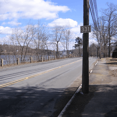
Route 331 outside Bridgewater beside the Lahave River.
It is located on the province's South Shore, connecting Mill Village at Highway 103 with Bridgewater at Route 325.
Communities
- Mill Village
- East Port Medway
- Vogler's Cove
- Cherry Hill
- Broad Cove
- Petite Rivière
- Crescent Beach
- West Dublin
- Dublin Shore
- LaHave
- Pentz
- West LaHave
- Pleasantville
- Conquerall Bank
- Bridgewater
Parks
- Rissers Beach Provincial Park
History
The entirety of Collector Highway 331 was once designated as Trunk Highway 31.
gollark: Passing a function pointer MAY be mildly less efficient.
gollark: It might make the binary huge due to monomorphization.
gollark: No, it should still work as a closure.
gollark: It does not return those, I misread it.
gollark: I think you could take `impl Fn` or something, sure.
References
- Atlantic Canada Back Road Atlas ISBN 978-1-55368-618-7 Page 87
This article is issued from Wikipedia. The text is licensed under Creative Commons - Attribution - Sharealike. Additional terms may apply for the media files.