Sunrise Trail
The Sunrise Trail is a scenic roadway in the Canadian province of Nova Scotia. It is located along the province's North Shore on the Northumberland Strait for 333 km (207 mi) from Amherst to the Canso Causeway.[1][2]
| Sunrise Trail | |
|---|---|
| Route information | |
| Length | 333 km[1] (207 mi) |
| Component highways | |
| Major junctions | |
| West end | |
| East end | Canso Causeway |
| Location | |
| Counties | Cumberland County, Colchester County, Pictou County, Antigonish County |
| Highway system | |
| Provincial highways in Nova Scotia 100-series | |
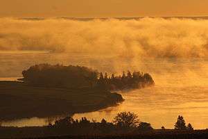
Sunrise over Antigonish Harbour on Nova Scotia's Sunrise Trail
Routes
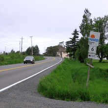
Nova Scotia Trunk 6 in the community of Toney River, about 16 kilometres east of Pictou
Communities
- Amherst
- Tidnish Bridge
- Tidnish
- Lorneville
- Port Howe
- Pugwash
- Wallace
- Malagash
- Tatamagouche
- River John
- Caribou
- Pictou
- New Glasgow
- Westville
- Antigonish
- Doctors Brook
- Lower Barney's River
- Morristown
- Cape George
- Georgeville
- Malignant Cove
- Tracadie
- Havre Boucher
- Auld's Cove
Parks
- Amherst Shore Provincial Park
- Arisaig
- Bayfield Beach
- Caribou/Munroes Island Provincial Park
- Fox Harbour Beach
- Gulf Shore Beach
- Heather Beach
- Melmerby Beach
- Nelson Memorial Provincial Park
- Northport Beach
- Powells Point
- Pomquet Beach
- Rushtons Beach
- Tatamagouche Provincial Park
- Tidnish Dock Provincial Park
- Waterside Beach
gollark: PotatOS.
gollark: Well, send it back if you won't give me the 1000 seeds.
gollark: I paid you 1KST.
gollark: Seeds please.
gollark: I can provide that 1 millikrist as you said; do you just want 1KST (rounded up) or will you give me 1000 seeds for 1KST?
References
- Google (April 10, 2020). "Sunrise Trail" (Map). Google Maps. Google. Retrieved April 10, 2020.
- Scenic Roadways Locator Map (PDF) (Map). 1:1,100,000. Province of Nova Scotia. 2019.
This article is issued from Wikipedia. The text is licensed under Creative Commons - Attribution - Sharealike. Additional terms may apply for the media files.