National Register of Historic Places listings in Grainger County, Tennessee
This is a list of the National Register of Historic Places listings in Grainger County, Tennessee.
Location of Grainger County in Tennessee
This is intended to be a complete list of the properties and districts on the National Register of Historic Places in Grainger County, Tennessee, United States. Latitude and longitude coordinates are provided for many National Register properties and districts; these locations may be seen together in a map.[1]
There are 10 properties and districts listed on the National Register in the county.
| Anderson – Bedford – Benton – Bledsoe – Blount – Bradley – Campbell – Cannon – Carroll – Carter – Cheatham – Chester – Claiborne – Clay – Cocke – Coffee – Crockett – Cumberland – Davidson – Decatur – DeKalb – Dickson – Dyer – Fayette – Fentress – Franklin – Gibson – Giles – Grainger – Greene – Grundy – Hamblen – Hamilton – Hancock – Hardeman – Hardin – Hawkins – Haywood – Henderson – Henry – Hickman – Houston – Humphreys – Jackson – Jefferson – Johnson – Knox – Lake – Lauderdale – Lawrence – Lewis – Lincoln – Loudon – Macon – Madison – Marion – Marshall – Maury – McMinn – McNairy – Meigs – Monroe – Montgomery – Moore – Morgan – Obion – Overton – Perry – Pickett – Polk – Putnam – Rhea – Roane – Robertson – Rutherford – Scott – Sequatchie – Sevier – Shelby – Smith – Stewart – Sullivan – Sumner – Tipton – Trousdale – Unicoi – Union – Van Buren – Warren – Washington – Wayne – Weakley – White – Williamson – Wilson |
- This National Park Service list is complete through NPS recent listings posted August 14, 2020.[2]
Current listings
| [3] | Name on the Register[4] | Image | Date listed[5] | Location | City or town | Description |
|---|---|---|---|---|---|---|
| 1 | William Cocke House | 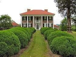 William Cocke House |
July 3, 1980 (#80003799) |
Northeast of Rutledge 36°18′06″N 83°27′24″W |
Rutledge | Home of Congressman William Michael Cocke |
| 2 | Henderson Chapel African Methodist Episcopal Zion Church | 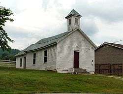 Henderson Chapel African Methodist Episcopal Zion Church |
June 22, 2000 (#00000730) |
Church St. 36°16′53″N 83°30′59″W |
Rutledge | |
| 3 | Lea Springs | May 29, 1975 (#75001754) |
11 miles southwest of Rutledge off U.S. Route 11W, west on Lea Lake Rd. 36°11′34″N 83°41′37″W |
Rutledge | ||
| 4 | Nance Building | 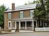 Nance Building |
July 1, 1998 (#98000824) |
Junction of Marshall St. and U.S. Route 11W 36°16′51″N 83°30′54″W |
Rutledge | https://npgallery.nps.gov/NRHP/GetAsset/NRHP/98000824_text |
| 5 | Old Grainger County Jail | 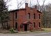 Old Grainger County Jail |
July 21, 2015 (#15000446) |
SE. corner of Water St. & TN 92 36°16′47″N 83°30′53″W |
Rutledge | |
| 6 | Poplar Hill | 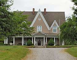 Poplar Hill |
July 8, 1980 (#80003798) |
Northeast of Blaine 36°10′40″N 83°41′00″W |
Blaine | Also known as the Cynthia Lea House |
| 7 | Richland | 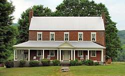 Richland |
November 19, 2014 (#14000941) |
1760 Rutledge Pike 36°10′25″N 83°41′11″W |
Blaine | |
| 8 | Rutledge Presbyterian Church and Cemetery | 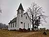 Rutledge Presbyterian Church and Cemetery |
July 21, 2015 (#15000447) |
123 Church St. 36°16′53″N 83°30′54″W |
Rutledge | |
| 9 | Shields' Station | 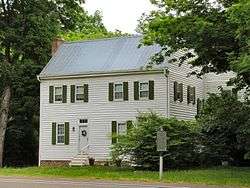 Shields' Station |
April 24, 1973 (#73001769) |
U.S. Route 11W 36°09′52″N 83°41′45″W |
Blaine | |
| 10 | Tate Springs Springhouse | 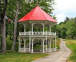 Tate Springs Springhouse |
April 13, 1973 (#73001768) |
East of Bean Station on U.S. Route 11W 36°20′18″N 83°20′44″W |
Bean Station |
gollark: My computer doesn't have a touchscreen and I can't type TeX that fast.
gollark: It's a very rare blue pen, because Amazon apparently no longer sell boxes of 100 pens.
gollark: I can contribute exactly £2.86 and a blue pen from my desk.
gollark: I guess it would be a great incentive to develop faster prime factoring algorithms, should such things be possible.
gollark: Just factoring random primes probably wouldn't be too useful.
See also
| Wikimedia Commons has media related to National Register of Historic Places in Grainger County, Tennessee. |
References
- The latitude and longitude information provided in this table was derived originally from the National Register Information System, which has been found to be fairly accurate for about 99% of listings. Some locations in this table may have been corrected to current GPS standards.
- "National Register of Historic Places: Weekly List Actions". National Park Service, United States Department of the Interior. Retrieved on August 14, 2020.
- Numbers represent an ordering by significant words. Various colorings, defined here, differentiate National Historic Landmarks and historic districts from other NRHP buildings, structures, sites or objects.
- "National Register Information System". National Register of Historic Places. National Park Service. April 24, 2008.
- The eight-digit number below each date is the number assigned to each location in the National Register Information System database, which can be viewed by clicking the number.
| Topics | |
|---|---|
| Lists by state |
|
| Lists by insular areas | |
| Lists by associated state | |
| Other areas | |
| Related | |
| |
Municipalities and communities of Grainger County, Tennessee, United States | ||
|---|---|---|
| Cities | ||
| Town | ||
| Unincorporated communities | ||
| Footnotes | ‡This populated place also has portions in an adjacent county or counties | |
This article is issued from Wikipedia. The text is licensed under Creative Commons - Attribution - Sharealike. Additional terms may apply for the media files.