National Register of Historic Places listings in Fentress County, Tennessee
This is a list of the National Register of Historic Places listings in Fentress County, Tennessee.
Location of Fentress County in Tennessee
This is intended to be a complete list of the properties and districts on the National Register of Historic Places in Fentress County, Tennessee, United States. Latitude and longitude coordinates are provided for many National Register properties and districts; these locations may be seen together in a map.[1]
There are 12 properties and districts listed on the National Register in the county, including 1 National Historic Landmark.
| Anderson – Bedford – Benton – Bledsoe – Blount – Bradley – Campbell – Cannon – Carroll – Carter – Cheatham – Chester – Claiborne – Clay – Cocke – Coffee – Crockett – Cumberland – Davidson – Decatur – DeKalb – Dickson – Dyer – Fayette – Fentress – Franklin – Gibson – Giles – Grainger – Greene – Grundy – Hamblen – Hamilton – Hancock – Hardeman – Hardin – Hawkins – Haywood – Henderson – Henry – Hickman – Houston – Humphreys – Jackson – Jefferson – Johnson – Knox – Lake – Lauderdale – Lawrence – Lewis – Lincoln – Loudon – Macon – Madison – Marion – Marshall – Maury – McMinn – McNairy – Meigs – Monroe – Montgomery – Moore – Morgan – Obion – Overton – Perry – Pickett – Polk – Putnam – Rhea – Roane – Robertson – Rutherford – Scott – Sequatchie – Sevier – Shelby – Smith – Stewart – Sullivan – Sumner – Tipton – Trousdale – Unicoi – Union – Van Buren – Warren – Washington – Wayne – Weakley – White – Williamson – Wilson |
- This National Park Service list is complete through NPS recent listings posted August 14, 2020.[2]
Current listings
| [3] | Name on the Register[4] | Image | Date listed[5] | Location | City or town | Description |
|---|---|---|---|---|---|---|
| 1 | Allardt Historic District | 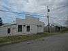 Allardt Historic District |
October 29, 1991 (#91001593) |
Junction of State Route 52 and Base Line Rd. 36°22′46″N 84°52′31″W |
Allardt | |
| 2 | Allardt Presbyterian Church | 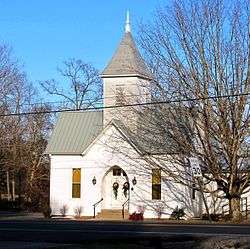 Allardt Presbyterian Church |
July 3, 1991 (#91000818) |
State Route 52 36°22′55″N 84°53′03″W |
Allardt | Carpenter Gothic-style church |
| 3 | James Beaty General Merchandise Store | 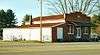 James Beaty General Merchandise Store |
December 18, 2013 (#13000947) |
5004 Alvin York Hwy. 36°16′01″N 84°59′05″W |
Grimsley | General store built in 1924 |
| 4 | Davidson School | 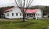 Davidson School |
January 7, 1993 (#92001739) |
State Route 85 36°16′42″N 85°06′16″W |
Davidson | Built in 1909 to serve the remote Davidson mining community |
| 5 | Forbus Historic District | 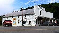 Forbus Historic District |
July 3, 1991 (#91000821) |
State Route 28 (U.S. Route 127) west of Pall Mall 36°33′54″N 85°00′42″W |
Forbus | |
| 6 | Gernt Office |  Gernt Office |
July 3, 1991 (#91000819) |
State Route 52 36°22′51″N 84°53′02″W |
Allardt | Offices of the Allardt Land Company, which colonized the area in the late 19th-century |
| 7 | Bruno Gernt House | 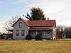 Bruno Gernt House |
March 6, 1987 (#87000391) |
Base Line Rd. 36°22′44″N 84°52′20″W |
Allardt | Homestead of Bruno Gernt (1851-1932), founder of Allardt |
| 8 | Old Fentress County Jail | 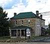 Old Fentress County Jail |
May 24, 1984 (#84003536) |
N. Smith St. and State Route 52 36°25′40″N 84°55′57″W |
Jamestown | Now the Ye Olde Jail Museum |
| 9 | Sergeant York Historic Area |  Sergeant York Historic Area |
April 11, 1973 (#73001763) |
Off the Alvin York Highway 36°32′52″N 84°57′44″W |
Pall Mall | |
| 10 | Alvin C. York Agricultural Institute Historic District |  Alvin C. York Agricultural Institute Historic District |
September 20, 1991 (#91001378) |
U.S. Route 127 south of its junction with State Route 154 36°26′40″N 84°56′13″W |
Jamestown | |
| 11 | Alvin Cullom York Farm | 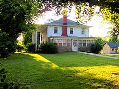 Alvin Cullom York Farm |
May 11, 1976 (#76001773) |
U.S. Route 127 36°32′36″N 84°57′35″W |
Pall Mall | |
| 12 | Youngs Historic District |  Youngs Historic District |
October 16, 1991 (#91000820) |
Junction of Indiana and Portland Aves. 36°22′44″N 84°53′02″W |
Allardt | This section south of Indiana Avenue (south of TN-52) has been renamed "Joe Youngs Street" |
gollark: Plausibly. You're not legally fine but they probably won't check all possible transforms.
gollark: But it isn't as if no number can be.
gollark: These are small enough numbers that they probably shouldn't be copyrightable.
gollark: Every file is just a very large number expressed in base 256.
gollark: What? They obviously can.
See also
| Wikimedia Commons has media related to National Register of Historic Places in Fentress County, Tennessee. |
References
- The latitude and longitude information provided in this table was derived originally from the National Register Information System, which has been found to be fairly accurate for about 99% of listings. Some locations in this table may have been corrected to current GPS standards.
- "National Register of Historic Places: Weekly List Actions". National Park Service, United States Department of the Interior. Retrieved on August 14, 2020.
- Numbers represent an ordering by significant words. Various colorings, defined here, differentiate National Historic Landmarks and historic districts from other NRHP buildings, structures, sites or objects.
- "National Register Information System". National Register of Historic Places. National Park Service. April 24, 2008.
- The eight-digit number below each date is the number assigned to each location in the National Register Information System database, which can be viewed by clicking the number.
| Topics | |
|---|---|
| Lists by state |
|
| Lists by insular areas | |
| Lists by associated state | |
| Other areas | |
| Related | |
| |
Municipalities and communities of Fentress County, Tennessee, United States | ||
|---|---|---|
| Cities | ||
| CDPs | ||
| Unincorporated communities | ||
This article is issued from Wikipedia. The text is licensed under Creative Commons - Attribution - Sharealike. Additional terms may apply for the media files.