Tate Springs, Tennessee
Tate Springs is an unincorporated community in Grainger County, Tennessee. It is part of the Morristown Metropolitan Statistical Area which consists of Grainger, Hamblen, and Jefferson counties.[3]
Tate Springs, Tennessee | |
|---|---|
Unincorporated community | |
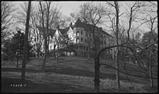 The former Tate Springs Resort Hotel circa 1940 | |
 Tate Springs  Tate Springs | |
| Coordinates: 36.340462°N 83.340508°W | |
| Country | United States |
| State | Tennessee |
| County | Grainger |
| Elevation | 1,119 ft (341 m) |
| Time zone | UTC-5 (Eastern (EST)) |
| • Summer (DST) | UTC-4 (EDT) |
| ZIP code | 37708 |
| Area code | 865 |
| FIPS code[2] | 47-47057 |
| GNIS feature ID[2][1] | 1304010 |
History
In the post-Civil War era, a businessman named Samuel Tate constructed a large Victorian-style luxury hotel in the community that became the main focus of a resort known as Tate Springs. Around the late 1870s, the hotel was purchased by Captain Thomas Tomlinson, who would transform the property into a vast resort that advertised the supposed healing powers of its mineral spring’s water.[4] During its heyday, the resort complex included over three-dozen buildings, a 100-acre (40 ha) park, and an 18-hole golf course.[5] The resort had attracted some of the wealthiest people in America during this time. The resort declined during the Great Depression, and the hotel and most of its outbuildings have since been demolished after a major fire damaged the main hotel structure. The Tate Springs Springhouse still stands just off U.S. Route 11W near Bean Station Elementary School.[6]
Since the 1960s, the resort site and its remaining cabins have been used by Kingswood Home for Children, a children's home and school.[7]
Geography
Tate Springs is located about 4 miles west of Bean Station, and parts of the community have since been annexed into the town.[8]
References
- "Tate Springs (Grainger County, Tennessee)". Geographic Names Information System. United States Geological Survey. Retrieved August 1, 2020.
- "FIPS55 Data: Tennessee". United States Geological Survey. February 23, 2006. Archived from the original on June 18, 2006.
- "Revised Delineations of Metropolitan Statistical Areas, Micropolitan Statistical Areas, and Combined Statistical Areas, and Guidance on Uses of the Delineations of These Areas" (PDF). Office of Management and Budget. Retrieved August 1, 2020.
- Phillips, Bud (July 18, 2010). "Tate Springs was once a popular health resort". Bristol Herald Courier. Retrieved July 2, 2020.
- "Spring Histories". Tennessee State Library and Archives. Retrieved July 2, 2020.
- Collins, Kevin (October 8, 2017). "Grainger County". TennesseeEncyclopedia.net. Tennessee Historical Society. Retrieved March 13, 2020.
- "Our Legacy". Kingswood Home for Children. Retrieved August 1, 2020.
- Google (August 1, 2020). "Tate Springs, Tennessee" (Map). Google Maps. Google. Retrieved August 1, 2020.
Municipalities and communities of Grainger County, Tennessee, United States | ||
|---|---|---|
| Cities | ||
| Town | ||
| Unincorporated communities | ||
| Footnotes | ‡This populated place also has portions in an adjacent county or counties | |