National Register of Historic Places listings in Hamblen County, Tennessee
This is a list of the National Register of Historic Places listings in Hamblen County, Tennessee.
Location of Hamblen County in Tennessee
This is intended to be a complete list of the properties and districts on the National Register of Historic Places in Hamblen County, Tennessee, United States. Latitude and longitude coordinates are provided for many National Register properties and districts; these locations may be seen together in a map.[1]
There are 13 properties and districts listed on the National Register in the county, and one former listing.
See also National Register of Historic Places listings in Jefferson County, Tennessee for additional properties in White Pine, a city that spans the county line.
| Anderson – Bedford – Benton – Bledsoe – Blount – Bradley – Campbell – Cannon – Carroll – Carter – Cheatham – Chester – Claiborne – Clay – Cocke – Coffee – Crockett – Cumberland – Davidson – Decatur – DeKalb – Dickson – Dyer – Fayette – Fentress – Franklin – Gibson – Giles – Grainger – Greene – Grundy – Hamblen – Hamilton – Hancock – Hardeman – Hardin – Hawkins – Haywood – Henderson – Henry – Hickman – Houston – Humphreys – Jackson – Jefferson – Johnson – Knox – Lake – Lauderdale – Lawrence – Lewis – Lincoln – Loudon – Macon – Madison – Marion – Marshall – Maury – McMinn – McNairy – Meigs – Monroe – Montgomery – Moore – Morgan – Obion – Overton – Perry – Pickett – Polk – Putnam – Rhea – Roane – Robertson – Rutherford – Scott – Sequatchie – Sevier – Shelby – Smith – Stewart – Sullivan – Sumner – Tipton – Trousdale – Unicoi – Union – Van Buren – Warren – Washington – Wayne – Weakley – White – Williamson – Wilson |
- This National Park Service list is complete through NPS recent listings posted August 14, 2020.[2]
Current listings
| [3] | Name on the Register[4] | Image | Date listed[5] | Location | City or town | Description |
|---|---|---|---|---|---|---|
| 1 | Barton Springs | .jpg) Barton Springs |
May 22, 1978 (#78002594) |
3 miles (4.8 km) east of Morristown 36°14′14″N 83°14′04″W |
Morristown | |
| 2 | Bethel Methodist Church | 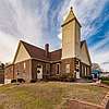 Bethel Methodist Church |
March 28, 2018 (#100002260) |
703 N. Cumberland St. 36°13′07″N 83°17′43″W |
Morristown | |
| 3 | Bethesda Presbyterian Church | 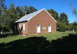 Bethesda Presbyterian Church |
April 11, 1973 (#73001771) |
About 2 miles southwest of Russellville off U.S. Route 11E 36°14′51″N 83°13′40″W |
Russellville | |
| 4 | Crockett Tavern Museum | 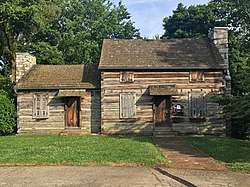 Crockett Tavern Museum |
December 18, 2013 (#13000948) |
2002 Morningside Dr. 36°13′17″N 83°16′03″W |
Morristown | |
| 5 | Hamblen County Courthouse | 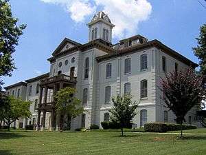 Hamblen County Courthouse |
April 13, 1973 (#73001770) |
511 W. 2nd N. St. 36°12′44″N 83°17′55″W |
Morristown | |
| 6 | Leeper Farm | 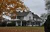 Leeper Farm |
March 21, 2007 (#07000174) |
5878 Leepers Ferry Rd. 36°07′27″N 83°15′09″W |
White Pine | |
| 7 | Morristown Main Street Historic District | 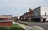 Morristown Main Street Historic District |
March 22, 2016 (#16000120) |
101-119 E. Main, 200-243 W. Main, 113-133, 118-134 N. Henry, 111-121 N. Cumberland, 110-128 S. Cumberland Sts. 36°12′49″N 83°17′35″W |
Morristown | |
| 8 | Phillips House | 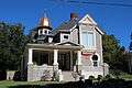 Phillips House |
April 4, 1996 (#96000384) |
307 E. 2nd N. St. 36°13′00″N 83°17′28″W |
Morristown | |
| 9 | Rose School | 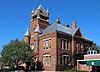 Rose School |
October 18, 1976 (#76001778) |
Jackson and W. 2nd N. Sts. 36°12′47″N 83°17′55″W |
Morristown | |
| 10 | Rural Mount | 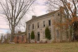 Rural Mount |
July 30, 1975 (#75001757) |
8 miles southeast of Morristown off State Route 160 36°08′44″N 83°11′23″W |
Morristown | Built by Alexander Outlaw for his son-in-law, Joseph Hamilton |
| 11 | St. Paul Presbyterian Church | 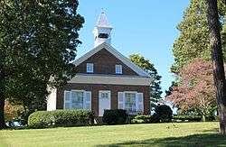 St. Paul Presbyterian Church |
August 10, 1979 (#79002434) |
West of Lowland 36°09′42″N 83°13′33″W |
Lowland | |
| 12 | U.S. Post Office | 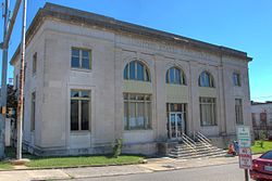 U.S. Post Office |
April 25, 1983 (#83003037) |
134 N. Henry St. 36°12′49″N 83°17′40″W |
Morristown | |
| 13 | Watkins-Witt House | Watkins-Witt House |
January 31, 1991 (#90001752) |
6622 W. Andrew Johnson Highway 36°10′09″N 83°24′23″W |
Talbott |
Former listings
| [3] | Name on the Register | Image | Date listed | Date removed | Location | City or town | Summary |
|---|---|---|---|---|---|---|---|
| 1 | Morristown College Historic District | 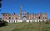 Morristown College Historic District |
September 15, 1983 (#83003036) | June 26, 2017 | 417 N. James St. 36°13′16″N 83°17′37″W |
Morristown | Fell into disrepair and demolished by the City of Morristown in late 2016 - early 2017 for new city park |
gollark: It hasn't been trained on image data, also.
gollark: And yet they are allegedly "OpenAI". Essentially, bee them into apiaristic metaspace.
gollark: Generate ALL posts via GPT-n.
gollark: https://macron.osmarks.net/
gollark: I could make macron.osmarks.net?
See also
| Wikimedia Commons has media related to National Register of Historic Places in Hamblen County, Tennessee. |
References
- The latitude and longitude information provided in this table was derived originally from the National Register Information System, which has been found to be fairly accurate for about 99% of listings. Some locations in this table may have been corrected to current GPS standards.
- "National Register of Historic Places: Weekly List Actions". National Park Service, United States Department of the Interior. Retrieved on August 14, 2020.
- Numbers represent an ordering by significant words. Various colorings, defined here, differentiate National Historic Landmarks and historic districts from other NRHP buildings, structures, sites or objects.
- "National Register Information System". National Register of Historic Places. National Park Service. April 24, 2008.
- The eight-digit number below each date is the number assigned to each location in the National Register Information System database, which can be viewed by clicking the number.
| Topics | |
|---|---|
| Lists by state |
|
| Lists by insular areas | |
| Lists by associated state | |
| Other areas | |
| Related | |
| |
Municipalities and communities of Hamblen County, Tennessee, United States | ||
|---|---|---|
| City | ||
| Town | ||
| Unincorporated communities | ||
| Footnotes | ‡This populated place also has portions in an adjacent county or counties | |
This article is issued from Wikipedia. The text is licensed under Creative Commons - Attribution - Sharealike. Additional terms may apply for the media files.