National Register of Historic Places listings in Hardeman County, Tennessee
This is a list of the National Register of Historic Places listings in Hardeman County, Tennessee.
Location of Hardeman County in Tennessee
This is intended to be a complete list of the properties and districts on the National Register of Historic Places in Hardeman County, Tennessee, United States. Latitude and longitude coordinates are provided for many National Register properties and districts; these locations may be seen together in a map.[1]
There are 12 properties and districts listed on the National Register in the county, including 1 National Historic Landmark. Another property was once listed but has been removed.
| Anderson – Bedford – Benton – Bledsoe – Blount – Bradley – Campbell – Cannon – Carroll – Carter – Cheatham – Chester – Claiborne – Clay – Cocke – Coffee – Crockett – Cumberland – Davidson – Decatur – DeKalb – Dickson – Dyer – Fayette – Fentress – Franklin – Gibson – Giles – Grainger – Greene – Grundy – Hamblen – Hamilton – Hancock – Hardeman – Hardin – Hawkins – Haywood – Henderson – Henry – Hickman – Houston – Humphreys – Jackson – Jefferson – Johnson – Knox – Lake – Lauderdale – Lawrence – Lewis – Lincoln – Loudon – Macon – Madison – Marion – Marshall – Maury – McMinn – McNairy – Meigs – Monroe – Montgomery – Moore – Morgan – Obion – Overton – Perry – Pickett – Polk – Putnam – Rhea – Roane – Robertson – Rutherford – Scott – Sequatchie – Sevier – Shelby – Smith – Stewart – Sullivan – Sumner – Tipton – Trousdale – Unicoi – Union – Van Buren – Warren – Washington – Wayne – Weakley – White – Williamson – Wilson |
- This National Park Service list is complete through NPS recent listings posted August 14, 2020.[2]
Current listings
| [3] | Name on the Register[4] | Image | Date listed[5] | Location | City or town | Description |
|---|---|---|---|---|---|---|
| 1 | Allen-White School | 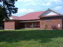 Allen-White School |
November 9, 2005 (#05001214) |
100 Allen Extension St. 35°20′01″N 89°08′51″W |
Whiteville | |
| 2 | James Monroe Avent House | April 25, 2001 (#01000436) |
220 Railroad Ave. 35°09′11″N 89°07′36″W |
Hickory Valley | ||
| 3 | Bills-McNeal Historic District | February 12, 1980 (#80003829) |
Irregular pattern along Lafayette, McNeal, Bills, Union, Lauderdale, and Washington Sts. 35°15′11″N 88°59′29″W |
Bolivar | ||
| 4 | Bolivar Court Square Historic District | 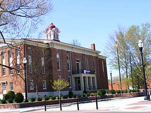 Bolivar Court Square Historic District |
January 10, 1980 (#80003830) |
U.S. Route 64 and State Route 125 35°15′22″N 88°59′13″W |
Bolivar | |
| 5 | Bolivar-Somerville Stage Road | August 7, 2005 (#05000802) |
Herron Dr., Stewart Rd., 4.0 miles southwest of Whiteville 35°15′02″N 89°11′13″W |
Whiteville | Extends into Fayette County | |
| 6 | Davis Bridge Battlefield | 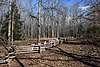 Davis Bridge Battlefield |
July 13, 1998 (#97001549) |
Roughly along Ripley-Pocahontas and Essary Spring Rds 35°01′51″N 88°47′44″W |
Pocahontas | Extends into Alcorn County, Mississippi |
| 7 | Hatchie River Ferry | August 7, 2005 (#05000800) |
End of Big Bend Ln, 1.0 mile south of State Route 15 35°13′27″N 88°55′00″W |
Bolivar | ||
| 8 | North Main Street Historic District | March 20, 1980 (#80003831) |
N. Main, Sycamore, Jefferson, Washing, and Water Sts. 35°15′36″N 88°59′18″W |
Bolivar | ||
| 9 | Pocahontas School | 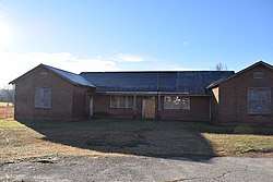 Pocahontas School |
July 19, 2007 (#07000706) |
22555 State Route 57 35°02′52″N 88°48′17″W |
Pocahontas | |
| 10 | Robertson Family Farm | November 8, 2007 (#07001164) |
2715 Newsom Rd. 35°20′42″N 89°07′30″W |
Whiteville | ||
| 11 | United Sons and Daughters of Charity Lodge Hall | November 9, 2005 (#05001222) |
322 W. McNeal St. 35°15′22″N 88°59′04″W |
Bolivar | ||
| 12 | Western State Hospital Historic District | June 25, 1987 (#87001057) |
U.S. Route 64 35°16′35″N 88°59′37″W |
Bolivar |
Former listing
| [3] | Name on the Register | Image | Date listed/removed | Location | City or town | Summary |
|---|---|---|---|---|---|---|
| 1 | Campbell House | Listed August 6, 1975, removed May 21, 1986 (#75001758) |
607 W. Market St. |
Bolivar |
gollark: A giant company is not some sort of hive mind, it's made out of thousands of people with their own motives and some access to things.
gollark: Google is big and it has many people in it.
gollark: You don't know that.
gollark: If you DID care about the google data gathering, you would in fact recognize that we consider that a valid reason to make our lives allegedly harder.
gollark: I don't think you're understanding the actual other side here.
See also
| Wikimedia Commons has media related to National Register of Historic Places in Hardeman County, Tennessee. |
References
- The latitude and longitude information provided in this table was derived originally from the National Register Information System, which has been found to be fairly accurate for about 99% of listings. Some locations in this table may have been corrected to current GPS standards.
- "National Register of Historic Places: Weekly List Actions". National Park Service, United States Department of the Interior. Retrieved on August 14, 2020.
- Numbers represent an ordering by significant words. Various colorings, defined here, differentiate National Historic Landmarks and historic districts from other NRHP buildings, structures, sites or objects.
- "National Register Information System". National Register of Historic Places. National Park Service. April 24, 2008.
- The eight-digit number below each date is the number assigned to each location in the National Register Information System database, which can be viewed by clicking the number.
| Topics | |
|---|---|
| Lists by state |
|
| Lists by insular areas | |
| Lists by associated state | |
| Other areas | |
| Related | |
| |
Municipalities and communities of Hardeman County, Tennessee, United States | ||
|---|---|---|
| Cities | Hardeman County map | |
| Towns | ||
| Unincorporated communities | ||
| Footnotes | ‡This populated place also has portions in an adjacent county or counties | |
This article is issued from Wikipedia. The text is licensed under Creative Commons - Attribution - Sharealike. Additional terms may apply for the media files.