National Register of Historic Places listings in Henry County, Tennessee
This is a list of the National Register of Historic Places listings in Henry County, Tennessee.
Location of Henry County in Tennessee
This is intended to be a complete list of the properties and districts on the National Register of Historic Places in Henry County, Tennessee, United States. Latitude and longitude coordinates are provided for many National Register properties and districts; these locations may be seen together in a map.[1]
There are 14 properties and districts listed on the National Register in the county, and one formerly listed property.
| Anderson – Bedford – Benton – Bledsoe – Blount – Bradley – Campbell – Cannon – Carroll – Carter – Cheatham – Chester – Claiborne – Clay – Cocke – Coffee – Crockett – Cumberland – Davidson – Decatur – DeKalb – Dickson – Dyer – Fayette – Fentress – Franklin – Gibson – Giles – Grainger – Greene – Grundy – Hamblen – Hamilton – Hancock – Hardeman – Hardin – Hawkins – Haywood – Henderson – Henry – Hickman – Houston – Humphreys – Jackson – Jefferson – Johnson – Knox – Lake – Lauderdale – Lawrence – Lewis – Lincoln – Loudon – Macon – Madison – Marion – Marshall – Maury – McMinn – McNairy – Meigs – Monroe – Montgomery – Moore – Morgan – Obion – Overton – Perry – Pickett – Polk – Putnam – Rhea – Roane – Robertson – Rutherford – Scott – Sequatchie – Sevier – Shelby – Smith – Stewart – Sullivan – Sumner – Tipton – Trousdale – Unicoi – Union – Van Buren – Warren – Washington – Wayne – Weakley – White – Williamson – Wilson |
- This National Park Service list is complete through NPS recent listings posted August 14, 2020.[2]
Current listings
| [3] | Name on the Register[4] | Image | Date listed[5] | Location | City or town | Description |
|---|---|---|---|---|---|---|
| 1 | Barrs Chapel C.M.E. Church | November 25, 2005 (#05001335) |
5560 Briarpatch Lake Rd. 36°18′19″N 88°29′11″W |
Midway | ||
| 2 | E.W. Grove Henry County High School | November 25, 1980 (#80003835) |
Grove Boulevard 36°17′34″N 88°19′45″W |
Paris | ||
| 3 | John L. Hagler House | March 13, 1980 (#80003836) |
Northwest of Springville on Poplar Grove Rd. 36°15′42″N 88°09′43″W |
Springville | ||
| 4 | E.K. Jernigan House | September 7, 1988 (#88001429) |
207 Dunlap St. 36°18′05″N 88°19′23″W |
Paris | ||
| 5 | Thomas P. Jernigan House | September 7, 1988 (#88001430) |
918 Dunlap St. 36°17′27″N 88°19′34″W |
Paris | ||
| 6 | Robert E. Lee School | 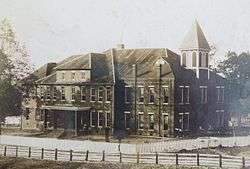 Robert E. Lee School |
September 7, 1988 (#88001426) |
402 Lee St. 36°18′21″N 88°19′48″W |
Paris | |
| 7 | Mt. Zion Church and Cemetery | 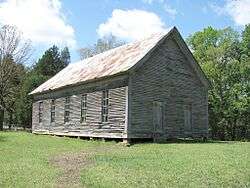 Mt. Zion Church and Cemetery |
December 23, 1974 (#74001916) |
Northeast of Elkhorn on the Tennessee River 36°22′18″N 88°02′31″W |
Elkhorn | |
| 8 | North Poplar Historic District | September 7, 1988 (#88001428) |
Along sections of N. Poplar St. and E. Church St. 36°18′25″N 88°19′30″W |
Paris | ||
| 9 | Obion Mounds | May 7, 1973 (#73001790) |
Address Restricted. 36°24′20″N 88°22′57″W |
Paris | ||
| 10 | Paris Commercial Historic District | 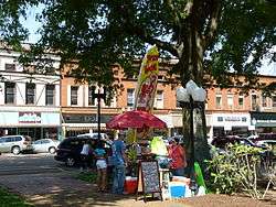 Paris Commercial Historic District |
September 7, 1988 (#88001424) |
Along sections of E. and W. Wood, W. Washington, N. and S. Poplar, N. and S. Market, Fentress, and W. Blythe Sts. 36°18′10″N 88°19′33″W |
Paris | |
| 11 | Porter House | .jpg) Porter House |
April 11, 1973 (#73001789) |
407 S. Dunlap St. 36°17′56″N 88°19′23″W |
Paris | |
| 12 | Judge John C. Sweeney House | September 7, 1988 (#88001427) |
1212 Chickasaw Rd. 36°18′32″N 88°18′11″W |
Paris | ||
| 13 | West Paris Historic District | 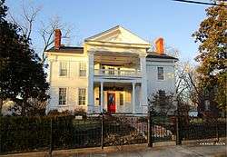 West Paris Historic District |
September 7, 1988 (#88001432) |
Along sections of W. Washington, N. College, and Hudson Sts. 36°18′14″N 88°19′50″W |
Paris | |
| 14 | Charles M. White House | September 7, 1988 (#88001425) |
403 Whitehall Circle 36°17′38″N 88°19′03″W |
Paris |
Former listings
| [3] | Name on the Register | Image | Date listed | Date removed | Location | City or town | Summary |
|---|---|---|---|---|---|---|---|
| 1 | H. L. Bruce House | September 7, 1988 (#88001431) | January 19, 2014 | 202 S. Poplar St. 36°18′04″N 88°19′32″W |
Paris |
gollark: You mean you put up the CB Copper and can't get a new release for it?
gollark: Why would anyone do ***THAT***?
gollark: Can you trade CB Prizes? Obviously nobody would, but it's interesting.
gollark: Huh. Someone actually put up a trade request with a CB copper asking for the release.
gollark: I wonder what they'll look like as adults...
See also
| Wikimedia Commons has media related to National Register of Historic Places in Henry County, Tennessee. |
References
- The latitude and longitude information provided in this table was derived originally from the National Register Information System, which has been found to be fairly accurate for about 99% of listings. Some locations in this table may have been corrected to current GPS standards.
- "National Register of Historic Places: Weekly List Actions". National Park Service, United States Department of the Interior. Retrieved on August 14, 2020.
- Numbers represent an ordering by significant words. Various colorings, defined here, differentiate National Historic Landmarks and historic districts from other NRHP buildings, structures, sites or objects.
- "National Register Information System". National Register of Historic Places. National Park Service. April 24, 2008.
- The eight-digit number below each date is the number assigned to each location in the National Register Information System database, which can be viewed by clicking the number.
| Topics | |
|---|---|
| Lists by state |
|
| Lists by insular areas | |
| Lists by associated state | |
| Other areas | |
| Related | |
| |
Municipalities and communities of Henry County, Tennessee, United States | ||
|---|---|---|
| Cities | Henry County map | |
| Towns | ||
| Unincorporated communities | ||
| Footnotes | ‡This populated place also has portions in an adjacent county or counties | |
This article is issued from Wikipedia. The text is licensed under Creative Commons - Attribution - Sharealike. Additional terms may apply for the media files.