Montgermont
Montgermont (Breton: Menezgervant, Gallo: Monjèrmont) is a commune in the Ille-et-Vilaine department of Brittany in northwestern France.
Montgermont Menezgervant | |
|---|---|
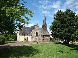 The church of Montgermont | |
.svg.png) Coat of arms | |
Location of Montgermont 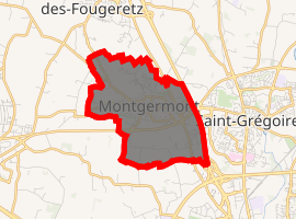
| |
 Montgermont  Montgermont | |
| Coordinates: 48°09′27″N 1°42′54″W | |
| Country | France |
| Region | Brittany |
| Department | Ille-et-Vilaine |
| Arrondissement | Rennes |
| Canton | Betton |
| Intercommunality | Rennes Métropole |
| Government | |
| • Mayor (2014–2020) | Brigitte Le Men |
| Area 1 | 4.67 km2 (1.80 sq mi) |
| Population (2017-01-01)[1] | 3,364 |
| • Density | 720/km2 (1,900/sq mi) |
| Time zone | UTC+01:00 (CET) |
| • Summer (DST) | UTC+02:00 (CEST) |
| INSEE/Postal code | 35189 /35760 |
| Elevation | 34–62 m (112–203 ft) |
| 1 French Land Register data, which excludes lakes, ponds, glaciers > 1 km2 (0.386 sq mi or 247 acres) and river estuaries. | |
Population
Inhabitants of Montgermont are called in French Montgermontais.
| Year | Pop. | ±% |
|---|---|---|
| 1962 | 455 | — |
| 1968 | 606 | +33.2% |
| 1975 | 1,099 | +81.4% |
| 1982 | 1,976 | +79.8% |
| 1990 | 2,395 | +21.2% |
| 1999 | 2,758 | +15.2% |
| 2008 | 3,039 | +10.2% |
gollark: Graphs of things like e^x, I assume.
gollark: See, you have to have the perfect balance of hating humans enough that it wants to spend its entire existence beating them at a mostly meaningless game, and being incompetent and underpowered enough that it won't become sentient and wipe out humanity.
gollark: I doubt it. Anyway, I'm busy working on the AI code.
gollark: If I did that, I would have to write a lot of annoying code to map all the positions onto isometric things, and code to draw the isometric thing in the first place.
gollark: So it just uses the existing grid output code.
References
- "Populations légales 2017". INSEE. Retrieved 6 January 2020.
- Mayors of Ille-et-Vilaine Association (in French)
External links
| Wikimedia Commons has media related to Montgermont. |
- Official website (in French)
- French Ministry of Culture list for Montgermont (in French)
| Authority control |
|
|---|
This article is issued from Wikipedia. The text is licensed under Creative Commons - Attribution - Sharealike. Additional terms may apply for the media files.