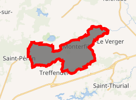
Monterfil
Monterfil (Breton: Mousterfil, Gallo: Mósterfiu) is a commune in the Ille-et-Vilaine department of Brittany in northwestern France.
Monterfil Mousterfil | |
|---|---|
The church of Saint-Étienne | |
 Coat of arms | |
Location of Monterfil 
| |
 Monterfil  Monterfil | |
| Coordinates: 48°04′00″N 1°58′39″W | |
| Country | France |
| Region | Brittany |
| Department | Ille-et-Vilaine |
| Arrondissement | Rennes |
| Canton | Montfort-sur-Meu |
| Intercommunality | Pays de Brocéliande |
| Government | |
| • Mayor (2014–2020) | Michel Duault |
| Area 1 | 16.94 km2 (6.54 sq mi) |
| Population (2017-01-01)[1] | 1,327 |
| • Density | 78/km2 (200/sq mi) |
| Time zone | UTC+01:00 (CET) |
| • Summer (DST) | UTC+02:00 (CEST) |
| INSEE/Postal code | 35187 /35160 |
| Elevation | 32–132 m (105–433 ft) |
| 1 French Land Register data, which excludes lakes, ponds, glaciers > 1 km2 (0.386 sq mi or 247 acres) and river estuaries. | |
Population
| Year | Pop. | ±% |
|---|---|---|
| 1962 | 639 | — |
| 1968 | 594 | −7.0% |
| 1975 | 720 | +21.2% |
| 1982 | 868 | +20.6% |
| 1990 | 915 | +5.4% |
| 1999 | 978 | +6.9% |
| 2008 | 1,241 | +26.9% |
gollark: Oh, the GPS thing is because China deliberately offsets their maps with a weird algorithm, I assume.
gollark: It's a cool statistical phenomenon. Applies to lots of things.
gollark: https://en.m.wikipedia.org/wiki/Berkson's_paradox
gollark: So if you have a scatterplot of appearance goodness/personality goodness, what would otherwise be an ellipse of uncorrelation has the bottom left removed and it looks negatively correlated.
gollark: Those things are quite possibly entirely uncorrelated, but you probably only notice/consider people where the sum of appearance and personality is above some threshold.
References
- "Populations légales 2017". INSEE. Retrieved 6 January 2020.
- Mayors of Ille-et-Vilaine Association (in French)
External links
| Wikimedia Commons has media related to Monterfil. |
- French Ministry of Culture list for Monterfil (in French)
This article is issued from Wikipedia. The text is licensed under Creative Commons - Attribution - Sharealike. Additional terms may apply for the media files.