Boisgervilly
Boisgervilly (Breton: Koad-Yarnvili, Gallo: Boéz-Jergaud) is a commune in the Ille-et-Vilaine department in Brittany in northwestern France.
Boisgervilly Koad-Yarnvili | |
|---|---|
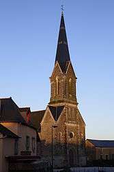 The church of Boisgervilly | |
Location of Boisgervilly 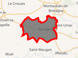
| |
 Boisgervilly  Boisgervilly | |
| Coordinates: 48°10′04″N 2°03′46″W | |
| Country | France |
| Region | Brittany |
| Department | Ille-et-Vilaine |
| Arrondissement | Rennes |
| Canton | Montauban-de-Bretagne |
| Intercommunality | Pays de Montauban-de-Bretagne |
| Government | |
| • Mayor (2014–2020) | Bernard Piedvache |
| Area 1 | 19.95 km2 (7.70 sq mi) |
| Population (2017-01-01)[1] | 1,664 |
| • Density | 83/km2 (220/sq mi) |
| Time zone | UTC+01:00 (CET) |
| • Summer (DST) | UTC+02:00 (CEST) |
| INSEE/Postal code | 35027 /35360 |
| Elevation | 58–111 m (190–364 ft) |
| 1 French Land Register data, which excludes lakes, ponds, glaciers > 1 km2 (0.386 sq mi or 247 acres) and river estuaries. | |
Population
| Year | Pop. | ±% |
|---|---|---|
| 1962 | 936 | — |
| 1968 | 936 | +0.0% |
| 1975 | 921 | −1.6% |
| 1982 | 1,074 | +16.6% |
| 1990 | 1,174 | +9.3% |
| 1999 | 1,215 | +3.5% |
| 2009 | 1,486 | +22.3% |
The inhabitants of Boisgervilly are known as Boisgervilliens in French.
Sights
The 19th-century church has an altar from the 17th century.
The chapel of St. Antoine was built in 1427.
gollark: Hmm, we can have that version for use in signatures.
gollark: I expect it'll be a while, since their profile says so.
gollark: If they say yes, we can use that nice one with the chrono coiling around the H.
gollark: I've PMed birdz.
gollark: I'll go PM birdz.
References
- "Populations légales 2017". INSEE. Retrieved 6 January 2020.
External links
| Wikimedia Commons has media related to Boisgervilly. |
- Official website (in French)
- French Ministry of Culture list for Boisgervilly (in French)
| Authority control |
|
|---|
This article is issued from Wikipedia. The text is licensed under Creative Commons - Attribution - Sharealike. Additional terms may apply for the media files.