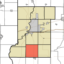
Linton Township, Vigo County, Indiana
Linton Township is one of twelve townships in Vigo County, Indiana, United States. As of the 2010 census, its population was 1,323 and it contained 555 housing units.[1]
Linton Township | |
|---|---|
 Location in Vigo County | |
| Coordinates: 39°18′23″N 87°24′43″W | |
| Country | United States |
| State | Indiana |
| County | Vigo |
| Government | |
| • Type | Indiana township |
| Area | |
| • Total | 35.43 sq mi (91.8 km2) |
| • Land | 34.97 sq mi (90.6 km2) |
| • Water | 0.46 sq mi (1.2 km2) 1.30% |
| Elevation | 574 ft (175 m) |
| Population (2010) | |
| • Total | 1,323 |
| • Density | 37.8/sq mi (14.6/km2) |
| ZIP codes | 47802, 47850, 47866 |
| GNIS feature ID | 453575 |
History
Linton Township High School and Community Building was listed on the National Register of Historic Places in 2002.[2]
Geography
According to the 2010 census, the township has a total area of 35.43 square miles (91.8 km2), of which 34.97 square miles (90.6 km2) (or 98.70%) is land and 0.46 square miles (1.2 km2) (or 1.30%) is water.[1]
Unincorporated communities
Adjacent townships
- Honey Creek Township (north)
- Riley Township (northeast)
- Pierson Township (east)
- Jackson Township, Sullivan County (southeast)
- Curry Township, Sullivan County (south)
- Fairbanks Township, Sullivan County (southwest)
- Prairie Creek Township (west)
- Prairieton Township (northwest)
Cemeteries
The township contains three cemeteries: Kester Family Cemetery, Brown, and Union.
Airports and landing strips
- Kester Fly Inn Airport
Lakes
- Fowler Lake
School districts
Political districts
- Indiana's 8th congressional district
- State House District 46
- State Senate District 39
gollark: …
gollark: Maybe if you actually worked on it instead of just dithering on trying to get <@378840449152188419> to look for weeks?
gollark: …
gollark: My ridiculously convoluted serialization scheme appears to break on it somehow.
gollark: On 5.3 I get it using debug.getupvalue and on CC using getfenv.
References
- United States Census Bureau 2007 TIGER/Line Shapefiles
- United States Board on Geographic Names (GNIS)
- IndianaMap
- "Population, Housing Units, Area, and Density: 2010 - County -- County Subdivision and Place -- 2010 Census Summary File 1". United States Census. Archived from the original on 2020-02-10. Retrieved 2013-05-10.
- "National Register Information System". National Register of Historic Places. National Park Service. July 9, 2010.
External links
This article is issued from Wikipedia. The text is licensed under Creative Commons - Attribution - Sharealike. Additional terms may apply for the media files.