Ehrmandale, Indiana
Ehrmandale is an unincorporated community in southern Nevins Township, Vigo County, in the U.S. state of Indiana.[2]
Ehrmandale, Indiana | |
|---|---|
 Vigo County's location in Indiana | |
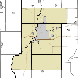 Ehrmandale location in Vigo County, Indiana | |
| Coordinates: 39°32′06″N 87°14′20″W | |
| Country | United States |
| State | Indiana |
| County | Vigo |
| Township | Nevins |
| Elevation | 594 ft (181 m) |
| Time zone | UTC-5 (Eastern (EST)) |
| • Summer (DST) | UTC-4 (EDT) |
| ZIP code | 47805 |
| Area code(s) | 812, 930 |
| GNIS feature ID | 434047 |
It is part of the Terre Haute metropolitan area.
History
Ehrmandale was known as Elsie until 1898.[3] A post office was established under this name in 1896, was renamed Ehrmandale in 1898, and was discontinued in 1905.[4]
Geography
Ehrmandale is located at 39°32′06″N 87°14′20″W at an elevation of 594 feet.
gollark: Oh, I see.
gollark: Did I already say bees?
gollark: Bees?
gollark: It can be shown trivially that no better humor can exist.
gollark: Yes. This is provably optimal humour.
References
- "US Board on Geographic Names". United States Geological Survey. October 25, 2007. Retrieved 2016-07-14.
- "Ehrmandale, Indiana". Geographic Names Information System. United States Geological Survey. Retrieved August 7, 2017.
- "USGS detail on Ehrmandale - Variant Citation". Retrieved 2016-07-14.
- "Vigo County". Jim Forte Postal History. Retrieved December 21, 2016.
Municipalities and communities of Vigo County, Indiana, United States | ||
|---|---|---|
| City | Map of Indiana highlighting Vigo County | |
| Towns | ||
| Townships | ||
| CDPs | ||
| Other unincorporated communities |
| |
| Footnotes | ‡This populated place also has portions in an adjacent county or counties | |
This article is issued from Wikipedia. The text is licensed under Creative Commons - Attribution - Sharealike. Additional terms may apply for the media files.