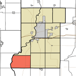
Prairie Creek Township, Vigo County, Indiana
Prairie Creek Township is one of twelve townships in Vigo County, Indiana, United States. As of the 2010 census, its population was 1,195 and it contained 494 housing units.[1]
Prairie Creek Township | |
|---|---|
 Location in Vigo County | |
| Coordinates: 39°17′52″N 87°31′53″W | |
| Country | United States |
| State | Indiana |
| County | Vigo |
| Government | |
| • Type | Indiana township |
| Area | |
| • Total | 38.55 sq mi (99.8 km2) |
| • Land | 37.99 sq mi (98.4 km2) |
| • Water | 0.56 sq mi (1.5 km2) 1.45% |
| Elevation | 489 ft (149 m) |
| Population (2010) | |
| • Total | 1,195 |
| • Density | 31.5/sq mi (12.2/km2) |
| ZIP codes | 47802, 47850 |
| GNIS feature ID | 453774 |
Geography
According to the 2010 census, the township has a total area of 38.55 square miles (99.8 km2), of which 37.99 square miles (98.4 km2) (or 98.55%) is land and 0.56 square miles (1.5 km2) (or 1.45%) is water.[1]
Unincorporated communities
Adjacent townships
- Prairieton Township (northeast)
- Linton Township (east)
- Curry Township, Sullivan County (southeast)
- Fairbanks Township, Sullivan County (south)
- York Township, Clark County, Illinois (southwest)
- Darwin Township, Clark County, Illinois (west)
Cemeteries
The township contains these four cemeteries: Lykens, Shattuck, Watson and Westlawn.
Rivers
School districts
Political districts
- Indiana's 8th congressional district
- State House District 45
- State Senate District 39
gollark: JS cannot be displaced and is immortal and inevitable, but it would be nice if it... had been?
gollark: If another sane language was in the place of JS, we would be better off, is the point.
gollark: It's not actually the only possible choice due to WASM and other thing→JS compilers.
gollark: It's not a better *language*, it just happens to be integrated in some important platforms.
gollark: BEE flexbox somewhat.
References
- United States Census Bureau 2007 TIGER/Line Shapefiles
- United States Board on Geographic Names (GNIS)
- IndianaMap
- "Population, Housing Units, Area, and Density: 2010 - County -- County Subdivision and Place -- 2010 Census Summary File 1". United States Census. Archived from the original on 2020-02-10. Retrieved 2013-05-10.
External links
This article is issued from Wikipedia. The text is licensed under Creative Commons - Attribution - Sharealike. Additional terms may apply for the media files.