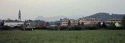
Curno
Curno (Bergamasque: Cüren) is a comune (municipality) in the Province of Bergamo in the Italian region of Lombardy, located about 40 kilometres (25 mi) northeast of Milan and about 6 kilometres (4 mi) southwest of Bergamo. As of 31 December 2006, it had a population of 7,590 and an area of 4.62 square kilometres (1.78 sq mi).[3]
Curno | |
|---|---|
| Comune di Curno | |
 Curno | |
Location of Curno 
| |
 Curno Location of Curno in Italy 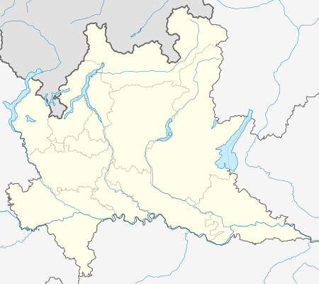 Curno Curno (Lombardy) | |
| Coordinates: 45°41′26″N 9°36′37″E | |
| Country | Italy |
| Region | Lombardy |
| Province | Province of Bergamo (BG) |
| Frazioni | Marigolda |
| Area | |
| • Total | 4.62 km2 (1.78 sq mi) |
| Elevation | 239 m (784 ft) |
| Population (Dec. 2006)[2] | |
| • Total | 7,590 |
| • Density | 1,600/km2 (4,300/sq mi) |
| Demonym(s) | Curnesi |
| Time zone | UTC+1 (CET) |
| • Summer (DST) | UTC+2 (CEST) |
| Postal code | 24035 |
| Dialing code | 035 |
The municipality of Curno contains the frazione (subdivision) Marigolda.
Curno borders the following municipalities: Bergamo, Bonate Sopra, Mozzo, Ponte San Pietro, Treviolo.
History
Before the 1960s, Curno was a village inhabited by farmers. Then, since the years of Miracolo economico, the main sector of activities has been industry. Since the first years of the 1990s, the municipality has allowed construction of many shopping malls in the area of the comune.
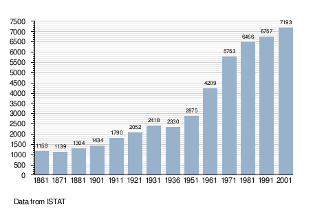
Demographic evolution
References
- "Superficie di Comuni Province e Regioni italiane al 9 ottobre 2011". Istat. Retrieved 16 March 2019.
- "Popolazione Residente al 1° Gennaio 2018". Istat. Retrieved 16 March 2019.
- All demographics and other statistics: Italian statistical institute Istat.