Golden Ears Way
Golden Ears Way is a two-to-six lane road[2] in Greater Vancouver, British Columbia. It connects Maple Ridge and Pitt Meadows to Langley and Surrey via the Golden Ears Bridge.[3] It is designed to keep traffic movements to and from the Golden Ears Bridge simple and streamlined, and intersections and interchanges have been placed with regards to accessing existing industrial and commercial areas on either side of the river in Port Kells and the Ridge-Meadows area of Maple Ridge, immediately west of Hammond.
| Golden Ears Way | ||||
|---|---|---|---|---|
| Pseudo Highway 916 | ||||
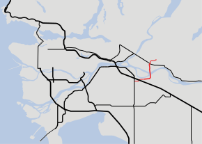
 Golden Ears Way highlighted in red. | ||||
| Route information | ||||
| Maintained by TransLink | ||||
| Length | 12.6 km[1] (7.8 mi) | |||
| Existed | 2009–present | |||
| Major junctions | ||||
| West end | ||||
| East end | 210th Street in Maple Ridge | |||
| Location | ||||
| Major cities | Surrey, Langley, Pitt Meadows, Maple Ridge | |||
| Highway system | ||||
British Columbia provincial highways
| ||||
The road is under the jurisdiction of TransLink, the organization responsible for the regional transportation network in the Greater Vancouver region.[4] On August 25, 2017, B.C. Premier John Horgan announced that all tolls on the Golden Ears bridge will be removed starting September 1, 2017.[5]
Route details
The expressway begins at 96th Avenue just west of Highway 15 in Surrey, a major route leading to the U.S. border, and continues eastward, passing through intersections to access the Port Kells Industrial Area. The Golden Ears Way becomes a freeway after the 192nd Street intersection and links 200th Street south to Langley City Centre, before curving northward onto the Golden Ears Bridge. In Maple Ridge, interchanges have been constructed close to commercial areas; a particular focus is the interchange at Highway 7, where most Golden Ears Way traffic is expected to exit the connector. The road past Highway 7 is mostly a two-laned expressway linking to residential and agricultural areas in the north of Maple Ridge, ending at the intersection with 210th Street and continuing beyond as 128th Avenue.
Exit list
The entire route is in Metro Vancouver.
| Location | km[1] | mi | Destinations | Notes | |||
|---|---|---|---|---|---|---|---|
| Surrey | 0.00 | 0.00 | Continues west as 96th Avenue towards Surrey City Centre | ||||
| At-grade, traffic signals | |||||||
| 0.70 | 0.43 | 180th Street | At-grade, traffic signals | ||||
| 1.70 | 1.06 | At-grade, traffic signals | |||||
| 3.40 | 2.11 | At-grade, traffic signals | |||||
| Langley (township) | 5.30 | 3.29 | Southbound exit only via 199A Street; northbound entrance only via 201st Street | ||||
| ↑ / ↓ | 6.20– 7.00 | 3.85– 4.35 | Golden Ears Bridge over the Fraser River | ||||
| Pitt Meadows – Maple Ridge boundary | 8.10 | 5.03 | 113B Avenue, Airport Way | Interchange; to Pitt Meadows Airport | |||
| 9.10 | 5.65 | Northbound exit; transit only southbound entrance | |||||
| 9.80 | 6.09 | Partially grade separated, traffic signals; no southbound access to BC 7 east | |||||
| 11.30 | 7.02 | 203rd Street | At-grade, traffic signals | ||||
| Maple Ridge | 12.60 | 7.83 | 210th Street | At-grade, traffic signals | |||
| Continues east as 128th Avenue | |||||||
| 1.000 mi = 1.609 km; 1.000 km = 0.621 mi | |||||||
References
- Landmark Kilometre Inventory (PDF). British Columbia Ministry of Transportation and Infrastructure (Report). Cypher Consulting. July 2016. pp. 572–574. Archived from the original (PDF) on 2017-03-11. Retrieved 2017-03-22.
- Melnychuk, Phil (June 16, 2009). "Abernethy Way now a major road". Maple Ridge News. Archived from the original on June 24, 2009.
- Riches, Al. "13th Annual Summer Solstice Run" (PDF). Classical Gas. 40 (4): 11. Archived from the original (PDF) on 2012.
- "Golden Ears Bridge & Tolling Info". TransLink. Retrieved March 22, 2017.
- Lindsay, Bethany (August 25, 2017). "Tolls to be eliminated on Port Mann and Golden Ears bridges". CBC News.