Windom Park, Minneapolis
Windom Park is a neighborhood in the Northeast community in Minneapolis. Its boundaries are Lowry Avenue NE to the north, New Brighton Boulevard to the east, 18th Avenue NE to the south, and Central Avenue to the west.
Windom Park | |
|---|---|
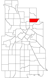 Location of Windom Park within the U.S. city of Minneapolis | |
| Country | United States |
| State | Minnesota |
| County | Hennepin |
| City | Minneapolis |
| Community | Northeast |
| Area | |
| • Total | 0.594 sq mi (1.54 km2) |
| Population (2010)[2] | |
| • Total | 5,678 |
| • Density | 9,600/sq mi (3,700/km2) |
| Time zone | UTC-6 (CST) |
| • Summer (DST) | UTC-5 (CDT) |
| ZIP code | 55418 |
| Area code(s) | 612 |
| Historical population | |||
|---|---|---|---|
| Census | Pop. | %± | |
| 1980 | 5,974 | — | |
| 1990 | 5,809 | −2.8% | |
| 2000 | 5,786 | −0.4% | |
| 2010 | 5,678 | −1.9% | |
The neighborhood's housing stock is split evenly between owned properties and rental properties. In 2006, the average home sale price in Windom Park was $240,500. In the west part of the neighborhood, houses were mostly built between 1895 and 1910. On the east side, most houses were built after World War II.
The rental property is primarily concentrated in a complex of apartments between Ulysses and Arthur Street south of 19th Avenue. Additional rental property is scattered throughout the neighborhood. Greater amounts of rental property exist west of Johnson than on the east side of the neighborhood.
References
- "Windom Park neighborhood in Minneapolis, Minnesota (MN), 55418 detailed profile". City-Data. 2011. Retrieved 2013-11-16.
- "Minneapolis Neighborhood Profile: Windom Park" (PDF). Minnesota Compass. October 2011. Retrieved 2013-11-15.
- Windom Park, Minneapolis, MN. Google Earth. Retrieved 2011-03-09.
External links
Places adjacent to Windom Park, Minneapolis | |
|---|---|