South Uptown, Minneapolis
South Uptown is a residential neighborhood of Minneapolis, Minnesota. In 2018, the neighborhood voted to change its name to South Uptown from its former name CARAG (Calhoun Area Residents' Action Group). Other potential names for the neighborhood included "Bryant Park" and "Bryant Square". The Minneapolis City Council has not yet approved the change.[3]
South Uptown | |
|---|---|
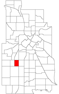 Location of South Uptown within the U.S. city of Minneapolis | |
| Country | United States |
| State | Minnesota |
| County | Hennepin |
| City | Minneapolis |
| Community | Calhoun-Isles |
| City Council Ward | 10 |
| Government | |
| • Council Member | Lisa Bender |
| Area | |
| • Total | 0.367 sq mi (0.95 km2) |
| Population (2010)[2] | |
| • Total | 5,647 |
| • Density | 15,000/sq mi (5,900/km2) |
| Time zone | UTC-6 (CST) |
| • Summer (DST) | UTC-5 (CDT) |
| ZIP code | 55408 |
| Area code(s) | 612 |
| Historical population | |||
|---|---|---|---|
| Census | Pop. | %± | |
| 1980 | 6,223 | — | |
| 1990 | 5,825 | −6.4% | |
| 2000 | 5,907 | 1.4% | |
| 2010 | 5,647 | −4.4% | |
South Uptown is part of the Calhoun Isles community of the city, in the southeastern part of that community. It is located directly south of Lowry Hill East and directly east of East Calhoun. Its boundaries are Lake Street to the north, Lyndale Avenue to the east, 36th Street to the south, and Hennepin Avenue to the west. South Uptown, Lowry Hill East, East Calhoun and East Isles form the business district of Uptown.
References
- "Carag neighborhood in Minneapolis, Minnesota (MN), 55408 detailed profile". City-Data. 2011. Retrieved 2013-11-12.
- "Minneapolis Neighborhood Profile: CARAG" (PDF). Minnesota Compass. October 2011. Retrieved 2013-11-12.
- Boller, Jay. "Minneapolis' CARAG neighborhood votes to switch name to South Uptown | City Pages". City Pages. Retrieved 2018-09-20.
External links
Places adjacent to South Uptown, Minneapolis | ||||||||||
|---|---|---|---|---|---|---|---|---|---|---|
| ||||||||||