Tangletown, Minneapolis
Tangletown is a neighborhood in the Southwest community of Minneapolis. The neighborhood was officially known as Fuller until 1996 when it was changed to the present name, which reflects the winding streets in the neighborhood that do not conform to the regular street grid of South Minneapolis. The neighborhood boundaries are 46th Street to the north, Interstate 35W to the east, Diamond Lake Road to the south, and Lyndale Avenue South to the west.
Tangletown | |
|---|---|
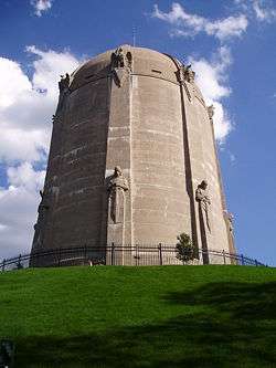 Washburn Park Water Tower is located at the highest point in the neighborhood. | |
| Nickname(s): Fuller | |
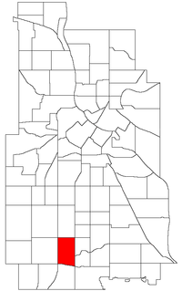 Location of Tangletown within the U.S. city of Minneapolis | |
| Coordinates: 44°54′44″N 93°17′0″W | |
| Country | United States |
| State | Minnesota |
| County | Hennepin |
| City | Minneapolis |
| Community | Southwest |
| Area | |
| • Total | 0.688 sq mi (1.78 km2) |
| Elevation | 900 ft (300 m) |
| Population (2010)[2] | |
| • Total | 4,351 |
| • Density | 6,300/sq mi (2,400/km2) |
| Time zone | UTC-6 (CST) |
| • Summer (DST) | UTC-5 (CDT) |
| ZIP code | 55409, 55419 |
| Area code(s) | 612 |
| Historical population | |||
|---|---|---|---|
| Census | Pop. | %± | |
| 1980 | 4,783 | — | |
| 1990 | 4,464 | −6.7% | |
| 2000 | 4,263 | −4.5% | |
| 2010 | 4,351 | 2.1% | |
The Washburn Park Water Tower is located at the highest point in the neighborhood, while Minnehaha Creek runs through the south side of the neighborhood. Washburn High School and Justice Page Middle School are located in this neighborhood.
Businesses
References
- "Tangletown neighborhood in Minneapolis, Minnesota (MN), 55409, 55419 detailed profile". City-Data. 2011. Retrieved 2013-11-19.
- "Minneapolis Neighborhood Profile: Tangletown" (PDF). Minnesota Compass. October 2011. Retrieved 2013-11-14.
External links
- Minneapolis Neighborhood Profile - Tangletown
- Tangletown Neighborhood Association
- Nicollet East Harriet Business Association
Places adjacent to Tangletown, Minneapolis | ||||||||||
|---|---|---|---|---|---|---|---|---|---|---|
| ||||||||||
This article is issued from Wikipedia. The text is licensed under Creative Commons - Attribution - Sharealike. Additional terms may apply for the media files.