Page, Minneapolis
Page is a neighborhood in the Nokomis community in Minneapolis. Its boundaries are the Minnehaha Creek to the north, Chicago Avenue to the east, Diamond Lake Road and East 55th Street to the south, and Interstate 35W to the west. Page shares a neighborhood organization with the Hale and Diamond Lake neighborhoods.
Page | |
|---|---|
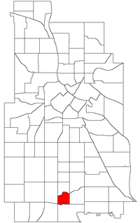 Location of Page within the U.S. city of Minneapolis | |
| Country | United States |
| State | Minnesota |
| County | Hennepin |
| City | Minneapolis |
| Community | Nokomis |
| Area | |
| • Total | 0.331 sq mi (0.86 km2) |
| Population (2010)[2] | |
| • Total | 1,730 |
| • Density | 5,200/sq mi (2,000/km2) |
| Time zone | UTC-6 (CST) |
| • Summer (DST) | UTC-5 (CDT) |
| ZIP code | 55417, 55419 |
| Area code(s) | 612 |
| Historical population | |||
|---|---|---|---|
| Census | Pop. | %± | |
| 1980 | 1,816 | — | |
| 1990 | 1,742 | −4.1% | |
| 2000 | 1,682 | −3.4% | |
| 2010 | 1,730 | 2.9% | |
The neighborhood is named after the now demolished Page Elementary School, which was in turn named in honor of author and diplomat Walter Hines Page.[4]
References
- "Page neighborhood in Minneapolis, Minnesota (MN), 55417, 55419 detailed profile". City-Data. 2011. Retrieved 2013-11-17.
- "Minneapolis Neighborhood Profile: Page" (PDF). Minnesota Compass. October 2011. Retrieved 2013-11-14.
- Page, Minneapolis, MN. Google Earth. Retrieved 2011-03-09.
- "Page". mpshistory.mpls.k12.mn.us. Retrieved 2019-11-26.
External links
- Minneapolis Neighborhood Profile - Page
- Hale-Page-Diamond Lake Community Association
- West Page Neighborhood Network
Places adjacent to Page, Minneapolis | ||||||||||
|---|---|---|---|---|---|---|---|---|---|---|
| ||||||||||
This article is issued from Wikipedia. The text is licensed under Creative Commons - Attribution - Sharealike. Additional terms may apply for the media files.