Wenonah, Minneapolis
Wenonah is a neighborhood on the southeast side of Minneapolis, Minnesota. Its boundaries are 54th Street to the north, 34th Avenue to the east, the Minneapolis-Saint Paul International Airport to the south, and Cedar Avenue to the west. The neighborhood contains a portion of Lake Nokomis. It shares a neighborhood organization with the Keewaydin, Minnehaha, and Morris Park neighborhoods, which are collectively referred to as Nokomis East and are served by the Nokomis East Neighborhood Association (NENA).
Wenonah | |
|---|---|
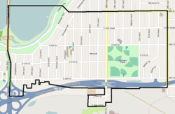 A map of Wenonah, bordered with black | |
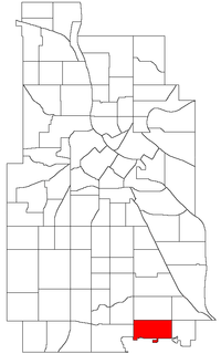 Wenonah's boundaries (top) and location within Minneapolis (bottom) | |
| Country | United States |
| State | Minnesota |
| County | Hennepin |
| City | Minneapolis |
| Community | Nokomis |
| Founded | 1849 |
| Area | |
| • Total | 1.226 sq mi (3.18 km2) |
| Population (2010)[2] | |
| • Total | 4,521 |
| • Density | 3,700/sq mi (1,400/km2) |
| Time zone | UTC-6 (CST) |
| • Summer (DST) | UTC-5 (CDT) |
| ZIP code | 55417 |
| Area code(s) | 612 |
Geography
Wenonah is located in the southeast portion of Minneapolis, as part of a greater community of 11 neighborhoods called Nokomis.[4] The neighborhood is about twice as long laterally as it is longitudinally, or about 6,500 by 3,000 feet (1,980 m × 910 m).[5] Its boundaries are defined by 54th Street East to the north, 34th Avenue South to the east, the Minneapolis-Saint Paul International Airport to the south, and Cedar Avenue to the west.[5] For the most part, the neighborhood lies to the north of Minnesota State Highway 62 with the exception of a vestigial 33-property area surrounded on three sides by the Airport and only connected to the greater neighborhood by 28th Avenue South,[5] which runs below Highway 62.[6] The neighborhood also encompasses a portion of Lake Nokomis to the northwest.[5]
Wenonah borders three other neighborhoods directly, including Diamond Lake to the west, Keewaydin to the north, and Morris Park to the east, and touches corners with Minnehaha to the northeast.[4] Keewaydin, Morris Park, Minnehaha, and Wenonah together comprise the community of Nokomis East.[6]
The neighborhood is generally very flat, with elevations between 814 and 821 feet (248 and 250 m) above sea level recorded by the United States Geological Survey in the neighborhood boundaries.[7] Lake Nokomis dips to 30 feet (9.1 m) below surface level in Wenonah's portion of the lake.[7]
Politics
For elections, Wenonah is a part of Minneapolis's eleventh ward.[8]
References
- "Wenonah neighborhood in Minneapolis, Minnesota (MN), 55417 detailed profile". City-Data. 2011. Retrieved 2013-11-12.
- "Minneapolis Neighborhood Profile: Wenonah" (PDF). Minnesota Compass. October 2011. Retrieved 2013-11-12.
- Wenonah, Minneapolis, MN. Google Earth. Retrieved 3 March 2011.
- City of Minneapolis Neighborhoods & Communities (PDF) (Map). City of Minneapolis GIS Business Services. 3 July 2008. Retrieved 8 August 2012.
- Wenonah (PDF) (Map). City of Minneapolis GIS Business Services. June 2006. Retrieved 8 August 2012.
- The Nokomis East Neighborhoods (Map). Nokomis East Neighborhood Association. 2007. Retrieved 8 August 2012.
- St Paul West Quadrangle (Map). 1: 24,000. V872. United States Geological Survey. 1993. Retrieved 8 August 2012.
- Wards and Election Precincts (PDF) (Map). City of Minneapolis GIS Business Services. 13 May 2005. Retrieved 13 August 2012.
External links
Places adjacent to Wenonah, Minneapolis | ||||||||||
|---|---|---|---|---|---|---|---|---|---|---|
| ||||||||||