Minnehaha, Minneapolis
Minnehaha is a neighborhood in the Nokomis community in Minneapolis, Minnesota. Its boundaries are Minnehaha Parkway to the north, Hiawatha Avenue to the east, 54th Street to the south, and 34th Avenue to the west. It shares a neighborhood organization with the Keewaydin, Morris Park, and Wenonah neighborhoods, which are collectively referred to as Nokomis East and served by the Nokomis East Neighborhood Association (NENA).
Minnehaha | |
|---|---|
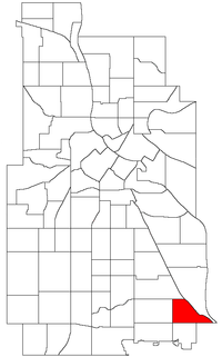 Location of Minnehaha within the U.S. city of Minneapolis | |
| Country | United States |
| State | Minnesota |
| Counties | Hennepin |
| Area | |
| • Total | 0.558 sq mi (1.45 km2) |
| Population (2010)[2] | |
| • Total | 3,980 |
| • Density | 7,100/sq mi (2,800/km2) |
| Time zone | UTC-6 (CST) |
| • Summer (DST) | UTC-5 (CDT) |
| ZIP code | 55417 |
| Area code(s) | 612 |
| Historical population | |||
|---|---|---|---|
| Census | Pop. | %± | |
| 1980 | 4,138 | — | |
| 1990 | 4,334 | 4.7% | |
| 2000 | 4,058 | −6.4% | |
| 2010 | 3,980 | −1.9% | |
The 50th Street/Minnehaha Park station of the METRO Blue Line is located in Minnehaha.
References
- "Minnehaha neighborhood in Minneapolis, Minnesota (MN), 55417 detailed profile". City-Data. 2011. Retrieved 2013-11-17.
- "Minneapolis Neighborhood Profile: Minnehaha" (PDF). Minnesota Compass. October 2011. Retrieved 2013-11-14.
- Minnehaha, Minneapolis, MN. Google Earth. Retrieved 2011-03-09.
External links
Places adjacent to Minnehaha, Minneapolis | ||||||||||
|---|---|---|---|---|---|---|---|---|---|---|
| ||||||||||
This article is issued from Wikipedia. The text is licensed under Creative Commons - Attribution - Sharealike. Additional terms may apply for the media files.