National Register of Historic Places listings in St. Clair County, Alabama
This is a list of the National Register of Historic Places listings in St. Clair County, Alabama.
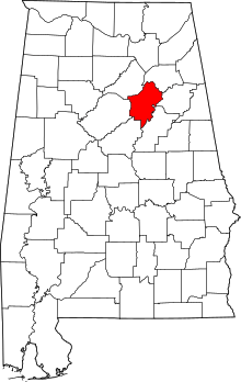
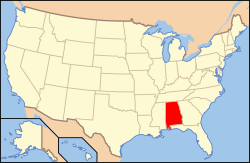
Location of St. Clair County in Alabama
This is intended to be a complete list of the properties and districts on the National Register of Historic Places in St. Clair County, Alabama, United States. Latitude and longitude coordinates are provided for many National Register properties and districts; these locations may be seen together in a Google map.[1]
There are 15 properties and districts listed on the National Register in the county.
- This National Park Service list is complete through NPS recent listings posted August 14, 2020.[2]
Current listings
| [3] | Name on the Register | Image | Date listed[4] | Location | City or town | Description |
|---|---|---|---|---|---|---|
| 1 | John Ash House | October 1, 1991 (#91001479) |
U.S. Route 411 west of its junction with U.S. Route 231 33°46′16″N 86°18′09″W |
Ashville | ||
| 2 | Ashville Historic District |  Ashville Historic District |
April 20, 2005 (#05000288) |
Bounded by State Route 23, Greensport Rd., 8th Ave., Waldrop Dr., State Route 231, and 5th St. 33°50′08″N 86°15′12″W |
Ashville | |
| 3 | Avondale Mill Historic District | 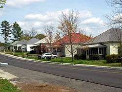 Avondale Mill Historic District |
August 31, 2000 (#00001030) |
Roughly bounded by 25th St., N., 7th Ave., N., 30th St., N., and south of 4th Ave., N. 33°35′33″N 86°16′42″W |
Pell City | |
| 4 | Dr. James J. Bothwell House |  Dr. James J. Bothwell House |
February 4, 1982 (#82004612) |
Hartford Ave. 33°50′06″N 86°15′17″W |
Ashville | |
| 5 | Fort Strother Site | July 24, 1972 (#72001440) |
Off Lock 3 Road along the Coosa River 33°45′49″N 86°02′51″W |
Ohatchee vicinity | ||
| 6 | Jacob Green House | January 20, 1980 (#80004238) |
East of Ashville on State Route 33 33°53′09″N 86°07′03″W |
Ashville | ||
| 7 | Inzer House | 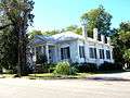 Inzer House |
December 4, 1973 (#73002127) |
Hartford Ave. 33°50′08″N 86°15′19″W |
Ashville | |
| 8 | Looney House |  Looney House |
December 31, 1974 (#74002179) |
5 miles west of Ashville on Greenport Rd. 33°49′16″N 86°11′33″W |
Ashville | |
| 9 | Rev. Thomas Newton House | October 11, 1991 (#91001480) |
South of U.S. Route 411, west of its junction with U.S. Route 231 33°45′22″N 86°18′58″W |
Ashville | ||
| 10 | Old Pell City Historic District | 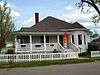 Old Pell City Historic District |
November 29, 2001 (#01001291) |
Roughly bounded by 16th St., N., 1st Ave., N., 22nd St., N., and 4th Ave., N. 33°35′17″N 86°17′10″W |
Pell City | |
| 11 | Pell City Downtown Historic District | 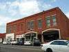 Pell City Downtown Historic District |
October 29, 2001 (#01001169) |
1900-2111 Cogwell Ave, 2008 1st Ave., S., 8 N. 21st St., and 10 S. 20th St. 33°35′11″N 86°17′04″W |
Pell City | |
| 12 | Presley Store | 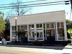 Presley Store |
January 11, 1983 (#83002982) |
601 Main St. 33°46′30″N 86°28′18″W |
Springville | |
| 13 | Judge Elisha Robinson House |  Judge Elisha Robinson House |
May 13, 1991 (#91000595) |
U.S. Route 231 south of its junction with State Route 23 33°50′05″N 86°15′19″W |
Ashville | |
| 14 | St. Clair Springs | April 26, 1976 (#76002140) |
State Route 23 33°45′51″N 86°24′17″W |
St. Clair Springs | ||
| 15 | Springville Historic District | 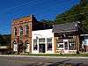 Springville Historic District |
July 3, 1997 (#97000653) |
Roughly bounded by Academy, Wilson, and Cross Sts., the Norfolk Southern railroad tracks, Industrial Dr., and Sarusce St. 33°46′33″N 86°28′14″W |
Springville |
See also
| Wikimedia Commons has media related to National Register of Historic Places in St. Clair County, Alabama. |
References
- The latitude and longitude information provided in this table was derived originally from the National Register Information System, which has been found to be fairly accurate for about 99% of listings. Some locations in this table may have been corrected to current GPS standards.
- "National Register of Historic Places: Weekly List Actions". National Park Service, United States Department of the Interior. Retrieved on August 14, 2020.
- Numbers represent an ordering by significant words. Various colorings, defined here, differentiate National Historic Landmarks and historic districts from other NRHP buildings, structures, sites or objects.
- The eight-digit number below each date is the number assigned to each location in the National Register Information System database, which can be viewed by clicking the number.
Municipalities and communities of St. Clair County, Alabama, United States | ||
|---|---|---|
| Cities | Map of Alabama highlighting St. Clair County | |
| Towns | ||
| Unincorporated communities | ||
| Former towns | ||
| Footnotes | ‡This populated place also has portions in an adjacent county or counties | |
This article is issued from Wikipedia. The text is licensed under Creative Commons - Attribution - Sharealike. Additional terms may apply for the media files.