National Register of Historic Places listings in Morgan County, Alabama
This is a list of the National Register of Historic Places listings in Morgan County, Alabama.

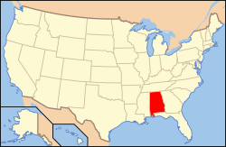
Location of Morgan County in Alabama
This is intended to be a complete list of the properties and districts on the National Register of Historic Places in Morgan County, Alabama, United States. Latitude and longitude coordinates are provided for many National Register properties and districts; these locations may be seen together in an online map.[1]
There are 17 properties and districts listed on the National Register in the county.
- This National Park Service list is complete through NPS recent listings posted August 14, 2020.[2]
Current listings
| [3] | Name on the Register | Image | Date listed[4] | Location | City or town | Description |
|---|---|---|---|---|---|---|
| 1 | Bank Street-Old Decatur Historic District |  Bank Street-Old Decatur Historic District |
March 27, 1980 (#80000731) |
Bank St.; also roughly bounded by Bank, Market, Well and Lee Sts. 34°36′36″N 86°59′06″W |
Decatur | Second set of boundaries represent a boundary increase of May 16, 1985, the Bank Street-Old Decatur Historic District |
| 2 | Cotaco Opera House | 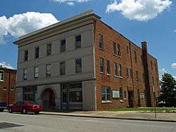 Cotaco Opera House |
April 29, 1986 (#86000914) |
115 Johnston St., SE. 34°36′10″N 86°59′09″W |
Decatur | |
| 3 | Crabb-Stewart-Key House | November 18, 2011 (#100004618) |
1084 Nat Key Rd. 34°23′34″N 86°51′16″W |
Hartselle vicinity | ||
| 4 | Col. Francis Dancy House |  Col. Francis Dancy House |
April 28, 1980 (#80000732) |
901 Railroad St., NW. 34°36′53″N 86°59′07″W |
Decatur | |
| 5 | East Old Town Historic District |  East Old Town Historic District |
December 26, 2012 (#12001079) |
NW Church Street to NW Wilson Street[5] 34°36′59″N 86°59′13″W |
Decatur | |
| 6 | Forest Home | November 21, 1980 (#80000733) |
East of Trinity 34°36′36″N 87°03′58″W |
Trinity | ||
| 7 | Hartselle Downtown Commercial Historic District |  Hartselle Downtown Commercial Historic District |
April 22, 1999 (#99000469) |
Roughly along Main, Railroad, Hickory, and Sparkman Sts. 34°26′36″N 86°56′03″W |
Hartselle | |
| 8 | Dr. William E. Murphey House | July 9, 1986 (#86001547) |
Off U.S. Route 72 34°38′38″N 87°05′53″W |
Trinity | One of the oldest frame houses in Alabama, c. 1818, it was destroyed by a tornado on April 27, 2011.[6] | |
| 9 | New Decatur-Albany Historic District |  New Decatur-Albany Historic District |
July 7, 1995 (#95000810) |
Roughly the 100 block of NE. 2nd Ave., the eastern side of the 100 block and the western side of the 300 block of SE. 2nd Ave., and parts of Johnson and Moulton Sts.; also 136 1st Ave., NE. 34°36′11″N 86°59′06″W |
Decatur | Second set of boundaries represents a boundary increase of February 12, 1999 |
| 10 | New Decatur-Albany Residential Historic District | 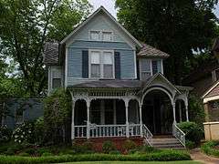 New Decatur-Albany Residential Historic District |
February 3, 1983 (#83002981) |
Roughly bounded by Gordon Dr., Summerville Rd., Jackson, 8th, Moulton, 6th, and 4th Aves.; also Grant, Jackson, and Sherman Sts. and Gordon and Prospect Drs. 34°36′00″N 86°58′40″W |
Decatur | Second set of boundaries represent a boundary increase of April 14, 2004, the New Decatur-Albany Residential Historic District. Originally enlisted as Albany Heritage Neighborhood Historic District. |
| 11 | Rhea-McEntire House | 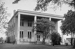 Rhea-McEntire House |
August 30, 1984 (#84000715) |
1105 Sycamore St. 34°37′02″N 86°59′05″W |
Decatur | |
| 12 | Green Pryor Rice House | 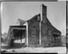 Green Pryor Rice House |
July 9, 1986 (#86001546) |
Junction of Madison and Monroe Sts. 34°28′27″N 86°47′43″W |
Somerville | |
| 13 | Somerville Courthouse | 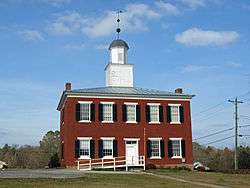 Somerville Courthouse |
March 24, 1972 (#72000177) |
State Route 36 34°28′22″N 86°47′54″W |
Somerville | The Somerville Courthouse was built in 1837 in the Federal style. It served as the county courthouse for Morgan County until the county seat was moved from Somerville to Decatur in 1891. |
| 14 | Southern Railway Depot |  Southern Railway Depot |
March 10, 1980 (#80004470) |
701 Railroad St., NW. 34°36′49″N 86°59′12″W |
Decatur | |
| 15 | State Bank Building, Decatur Branch | 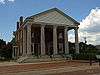 State Bank Building, Decatur Branch |
March 24, 1972 (#72000176) |
925 Bank St., NE. 34°36′52″N 86°59′01″W |
Decatur | |
| 16 | West Old Town Historic District |  West Old Town Historic District |
December 26, 2012 (#12001080) |
NW Alma Street to NW Vine Street[5] 34°37′06″N 86°59′39″W |
Decatur | |
| 17 | Westview | January 18, 1982 (#82002068) |
South of Decatur 34°29′55″N 86°55′52″W |
Decatur |
See also
| Wikimedia Commons has media related to National Register of Historic Places in Morgan County, Alabama. |
References
- The latitude and longitude information provided in this table was derived originally from the National Register Information System, which has been found to be fairly accurate for about 99% of listings. Some locations in this table may have been corrected to current GPS standards.
- "National Register of Historic Places: Weekly List Actions". National Park Service, United States Department of the Interior. Retrieved on August 14, 2020.
- Numbers represent an ordering by significant words. Various colorings, defined here, differentiate National Historic Landmarks and historic districts from other NRHP buildings, structures, sites or objects.
- The eight-digit number below each date is the number assigned to each location in the National Register Information System database, which can be viewed by clicking the number.
- "Alabama Properties Listed on the National Register of Historic Places" (PDF). Alabama Historical Commission. January 9, 2013. pp. 166–168. Retrieved June 5, 2013.
- "Preservation Report" (PDF). Alabama Historical Commission. July–August 2011. Archived from the original (PDF) on March 4, 2016. Retrieved November 4, 2011.
Municipalities and communities of Morgan County, Alabama, United States | ||
|---|---|---|
| Cities | Map of Alabama highlighting Morgan County | |
| Towns | ||
| Unincorporated communities | ||
| Ghost town | ||
| Former City | ||
| Former Town | ||
| Footnotes | ‡This populated place also has portions in an adjacent county or counties | |
This article is issued from Wikipedia. The text is licensed under Creative Commons - Attribution - Sharealike. Additional terms may apply for the media files.