National Register of Historic Places listings in Butler County, Alabama
This is a list of the National Register of Historic Places listings in Butler County, Alabama.

Location of Butler County in Alabama
This is intended to be a complete list of the properties and districts on the National Register of Historic Places in Butler County, Alabama, United States. Latitude and longitude coordinates are provided for many National Register properties and districts; these locations may be seen together in a Google map.[1]
There are 31 properties and districts listed on the National Register in the county.
- This National Park Service list is complete through NPS recent listings posted August 14, 2020.[2]
Current listings
| [3] | Name on the Register | Image | Date listed[4] | Location | City or town | Description |
|---|---|---|---|---|---|---|
| 1 | W.S. Blackwell House |  W.S. Blackwell House |
September 4, 1986 (#86001751) |
211 Ft. Dale St. 31°49′52″N 86°37′29″W |
Greenville | |
| 2 | Buell-Stallings-Stewart House | 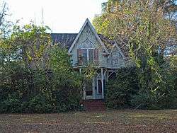 Buell-Stallings-Stewart House |
September 4, 1986 (#86001752) |
205 Ft. Dale St. 31°49′51″N 86°37′28″W |
Greenville | |
| 3 | Butler Chapel A.M.E. Zion Church |  Butler Chapel A.M.E. Zion Church |
September 4, 1986 (#86001755) |
407 Oglesby 31°49′25″N 86°37′30″W |
Greenville | |
| 4 | Commerce Street Residential Historic District |  Commerce Street Residential Historic District |
August 28, 1986 (#86001967) |
206, 212, 218, and 301 E. Commerce St. 31°49′46″N 86°37′18″W |
Greenville | |
| 5 | Confederate Park | 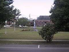 Confederate Park |
September 4, 1986 (#86001791) |
E. Commerce St. 31°49′45″N 86°37′23″W |
Greenville | |
| 6 | Dickenson House |  Dickenson House |
September 4, 1986 (#86001794) |
537 S. Conecuh St. 31°49′11″N 86°36′56″W |
Greenville | |
| 7 | East Commerce Street Historic District | 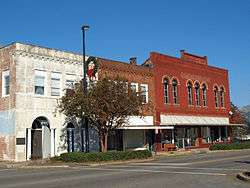 East Commerce Street Historic District |
November 4, 1986 (#86001966) |
Roughly bounded by Cedar, Chestnut, Commerce, and Hickory Sts. 31°49′47″N 86°37′08″W |
Greenville | |
| 8 | Evens-McMullan House |  Evens-McMullan House |
September 4, 1986 (#86001797) |
303 Bolling St. 31°49′36″N 86°37′40″W |
Greenville | |
| 9 | First Baptist Church |  First Baptist Church |
September 4, 1986 (#86001799) |
707 South St. 31°49′51″N 86°38′07″W |
Greenville | |
| 10 | First Presbyterian Church |  First Presbyterian Church |
September 4, 1986 (#86001801) |
215 E. Commerce St. 31°49′48″N 86°37′18″W |
Greenville | |
| 11 | Fort Dale-College Street Historic District | 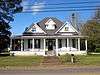 Fort Dale-College Street Historic District |
August 28, 1986 (#86001974) |
Roughly bounded by Ft. Dale, Hamilton, and N. College Sts. 31°50′04″N 86°37′50″W |
Greenville | |
| 12 | Gaston-Perdue House |  Gaston-Perdue House |
September 4, 1986 (#86001803) |
111 Cedar St. 31°49′51″N 86°37′23″W |
Greenville | |
| 13 | Graydon House | 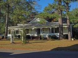 Graydon House |
September 4, 1986 (#86001805) |
507 Cedar St. 31°49′49″N 86°37′09″W |
Greenville | |
| 14 | Greenville City Hall |  Greenville City Hall |
November 4, 1986 (#86001807) |
E. Commerce St. 31°49′48″N 86°37′22″W |
Greenville | |
| 15 | Greenville Public School Complex | 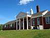 Greenville Public School Complex |
September 4, 1986 (#86001811) |
101 Butler Circle 31°50′01″N 86°37′31″W |
Greenville | |
| 16 | Hawthorne-Cowart House | 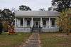 Hawthorne-Cowart House |
September 4, 1986 (#86001853) |
319 Bolling St. 31°49′34″N 86°37′44″W |
Greenville | |
| 17 | Hinson House | September 4, 1986 (#86001854) |
208 Oliver St. 31°49′52″N 86°37′29″W |
Greenville | Demolished as of March 2008 | |
| 18 | House at 308 South Street | September 4, 1986 (#86001856) |
308 South St. 31°49′49″N 86°37′28″W |
Greenville | Demolished as of March 2008 | |
| 19 | John W. Howard House and Outbuildings | 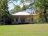 John W. Howard House and Outbuildings |
September 4, 1992 (#92001090) |
State Route 10E 31°44′59″N 86°27′32″W |
Greenville | |
| 20 | King Street Historic District | 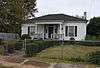 King Street Historic District |
August 28, 1986 (#86001971) |
Roughly bounded by W. Commerce, Oliver, Milner, and King Sts. 31°49′44″N 86°37′48″W |
Greenville | |
| 21 | Lane-Kendrick-Sherling House | 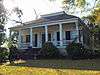 Lane-Kendrick-Sherling House |
September 4, 1986 (#86001858) |
109 Ft. Dale St. 31°49′50″N 86°37′28″W |
Greenville | |
| 22 | Little-Stabler House | 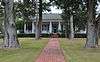 Little-Stabler House |
November 4, 1986 (#86001861) |
710 Ft. Dale St. 31°50′17″N 86°38′00″W |
Greenville | |
| 23 | McMullan-Skinner House | September 4, 1986 (#86001865) |
204 Oliver St. 31°49′51″N 86°37′28″W |
Greenville | Demolished as of March 2008 | |
| 24 | Oakey Streak Methodist Episcopal Church | 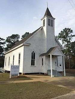 Oakey Streak Methodist Episcopal Church |
January 4, 1980 (#80000680) |
Off State Route 59 31°33′08″N 86°32′13″W |
Greenville | |
| 25 | Post Office Historic District |  Post Office Historic District |
November 4, 1986 (#86001968) |
100-115 W. Commerce and 101 E. Commerce Sts. 31°49′47″N 86°37′28″W |
Greenville | |
| 26 | South Greenville Historic District | 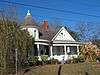 South Greenville Historic District |
August 28, 1986 (#86001965) |
Roughly bounded by Walnut, S. Conecuh, Parmer, and Church and Harrison and Caldwell Sts. 31°49′39″N 86°37′20″W |
Greenville | |
| 27 | South Street Historic District |  South Street Historic District |
August 28, 1986 (#86001972) |
Roughly bounded by South, Oliver, and McKenzie Sts. 31°49′52″N 86°37′48″W |
Greenville | |
| 28 | Theological Building-A.M.E. Zion Theological Institute | September 4, 1986 (#86001867) |
E. Conecuh St. 31°48′54″N 86°36′48″W |
Greenville | Demolished as of April 2014 | |
| 29 | Ward Nicholson Corner Store | 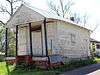 Ward Nicholson Corner Store |
November 4, 1986 (#86001870) |
219 W. Parmer 31°49′25″N 86°37′36″W |
Greenville | |
| 30 | West Commerce Street Historic District | 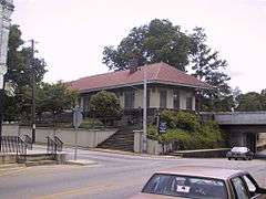 West Commerce Street Historic District |
August 28, 1986 (#86001970) |
Roughly bounded by W. Commerce, Bolling, and Milner Sts., and the former Louisville and Nashville railroad line 31°49′46″N 86°37′39″W |
Greenville | |
| 31 | Wright-Kilgore House | 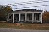 Wright-Kilgore House |
September 4, 1986 (#86001873) |
808 Walnut St. 31°49′43″N 86°36′59″W |
Greenville |
See also
| Wikimedia Commons has media related to National Register of Historic Places in Butler County, Alabama. |
References
- The latitude and longitude information provided in this table was derived originally from the National Register Information System, which has been found to be fairly accurate for about 99% of listings. Some locations in this table may have been corrected to current GPS standards.
- "National Register of Historic Places: Weekly List Actions". National Park Service, United States Department of the Interior. Retrieved on August 14, 2020.
- Numbers represent an ordering by significant words. Various colorings, defined here, differentiate National Historic Landmarks and historic districts from other NRHP buildings, structures, sites or objects.
- The eight-digit number below each date is the number assigned to each location in the National Register Information System database, which can be viewed by clicking the number.
Municipalities and communities of Butler County, Alabama, United States | ||
|---|---|---|
| City | Map of Alabama highlighting Butler County | |
| Towns | ||
| Unincorporated communities | ||
| Footnotes | ‡This populated place also has portions in an adjacent county or counties | |
This article is issued from Wikipedia. The text is licensed under Creative Commons - Attribution - Sharealike. Additional terms may apply for the media files.