National Register of Historic Places listings in Elmore County, Alabama
This is a list of the National Register of Historic Places listings in Elmore County, Alabama.
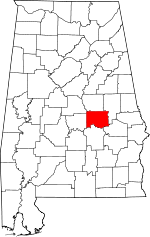
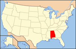
Location of Elmore County in Alabama
This is intended to be a complete list of the properties and districts on the National Register of Historic Places in Elmore County, Alabama, United States. Latitude and longitude coordinates are provided for many National Register properties and districts; these locations may be seen together in a Google map.[1]
There are 13 properties and districts listed on the National Register in the county, including 1 National Historic Landmark.
- This National Park Service list is complete through NPS recent listings posted August 14, 2020.[2]
Current listings
| [3] | Name on the Register | Image | Date listed[4] | Location | City or town | Description |
|---|---|---|---|---|---|---|
| 1 | Alabama State Penitentiary |  Alabama State Penitentiary |
May 8, 1973 (#73000342) |
Northeast of Wetumpka on U.S. Route 231 32°33′02″N 86°11′28″W |
Wetumpka | |
| 2 | East Wetumpka Commercial Historic District |  East Wetumpka Commercial Historic District |
February 20, 1992 (#92000055) |
Roughly Company St. from Spring St. to E. Bridge St. and E. Bridge and Commerce Sts. from Main to Hill Sts. 32°32′16″N 86°12′16″W |
Wetumpka | |
| 3 | Ellerslie | December 24, 2013 (#13000957) |
2650 Edgewood Rd. 32°28′08″N 86°22′38″W |
Millbrook vicinity | ||
| 4 | First Baptist Church of Wetumpka |  First Baptist Church of Wetumpka |
October 24, 2008 (#06001101) |
205 W. Bridge St. 32°32′21″N 86°12′35″W |
Wetumpka | |
| 5 | First Presbyterian Church of Wetumpka | 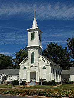 First Presbyterian Church of Wetumpka |
October 8, 1976 (#76000324) |
W. Bridge St. 32°32′21″N 86°12′31″W |
Wetumpka | |
| 6 | First United Methodist Church | 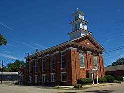 First United Methodist Church |
February 15, 1973 (#73000343) |
308 Tuskeena St. 32°32′25″N 86°12′12″W |
Wetumpka | |
| 7 | Fort Toulouse | 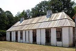 Fort Toulouse |
October 15, 1966 (#66000148) |
4 miles (6.4 km) southwest of Wetumpka at the confluence of the Coosa and Tallapoosa rivers 32°30′16″N 86°15′26″W |
Wetumpka | |
| 8 | Abel Hagerty House |  Abel Hagerty House |
January 14, 2008 (#07001389) |
4690 Jasmine Hill Rd. 32°28′23″N 86°11′17″W |
Wetumpka | |
| 9 | Hickory Ground | March 10, 1980 (#80000685) |
Southwest of Wetumpka 32°31′16″N 86°15′24″W |
Wetumpka | ||
| 10 | Robinson Springs United Methodist Church |  Robinson Springs United Methodist Church |
March 1, 1982 (#82002012) |
State Routes 14 and 143 32°30′55″N 86°22′28″W |
Millbrook | |
| 11 | Tallassee Commercial Historic District |  Tallassee Commercial Historic District |
March 6, 1992 (#92000072) |
Roughly 3 blocks on the southern side of Barnett Boulevard between old River Rd. and DuBois St. 32°31′57″N 85°53′44″W |
Tallassee | |
| 12 | Tallassee Mills | 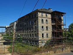 Tallassee Mills |
April 26, 2010 (#09000734) |
1844 Old Mill Rd. 32°31′57″N 85°53′24″W |
Tallassee | |
| 13 | Wetumpka L&N Depot |  Wetumpka L&N Depot |
July 1, 1975 (#75000312) |
Coosa St. 32°32′26″N 86°12′41″W |
Wetumpka |
See also
| Wikimedia Commons has media related to National Register of Historic Places in Elmore County, Alabama. |
References
- The latitude and longitude information provided in this table was derived originally from the National Register Information System, which has been found to be fairly accurate for about 99% of listings. Some locations in this table may have been corrected to current GPS standards.
- "National Register of Historic Places: Weekly List Actions". National Park Service, United States Department of the Interior. Retrieved on August 14, 2020.
- Numbers represent an ordering by significant words. Various colorings, defined here, differentiate National Historic Landmarks and historic districts from other NRHP buildings, structures, sites or objects.
- The eight-digit number below each date is the number assigned to each location in the National Register Information System database, which can be viewed by clicking the number.
Municipalities and communities of Elmore County, Alabama, United States | ||
|---|---|---|
| Cities | Map of Alabama highlighting Elmore County | |
| Towns | ||
| CDPs | ||
| Unincorporated communities | ||
| Indian reservation | ||
| Footnotes | ‡This populated place also has portions in an adjacent county or counties | |
This article is issued from Wikipedia. The text is licensed under Creative Commons - Attribution - Sharealike. Additional terms may apply for the media files.