National Register of Historic Places listings in Talladega County, Alabama
This is a list of the National Register of Historic Places listings in Talladega County, Alabama.
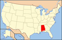
Location of Talladega County in Alabama
This is intended to be a complete list of the properties and districts on the National Register of Historic Places in Talladega County, Alabama, United States. Latitude and longitude coordinates are provided for many National Register properties and districts; these locations may be seen together in a Google map.[1]
There are 24 properties and districts listed on the National Register in the county, including 2 National Historic Landmarks.
- This National Park Service list is complete through NPS recent listings posted August 14, 2020.[2]
Current listings
| [3] | Name on the Register | Image | Date listed[4] | Location | City or town | Description |
|---|---|---|---|---|---|---|
| 1 | Benjamin H. Averiett House | August 28, 1986 (#86002034) |
State Route 8 33°08′25″N 86°22′21″W |
Sylacauga | ||
| 2 | William Averiett House |  William Averiett House |
August 28, 1986 (#86002038) |
Off State Route 8 33°08′02″N 86°23′58″W |
Sylacauga | |
| 3 | Boxwood | 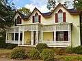 Boxwood |
June 9, 1983 (#83002983) |
406 E. North St., E. 33°26′13″N 86°05′47″W |
Talladega | |
| 4 | Charles Butler House | 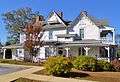 Charles Butler House |
February 26, 1996 (#96000054) |
Junction of 1st St. and 10th Ave. 33°16′38″N 86°21′26″W |
Childersburg | |
| 5 | B.B. Comer Memorial Library |  B.B. Comer Memorial Library |
September 6, 2005 (#05000972) |
711 N. Broadway Ave. 33°10′39″N 86°15′04″W |
Sylacauga | The building currently houses the Isabel Anderson Comer Museum & Arts Center |
| 6 | J.L.M. Curry House | 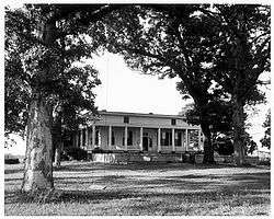 J.L.M. Curry House |
October 15, 1966 (#66000154) |
3 mi (4.8 km) northeast of Talladega on State Route 21 33°27′17″N 86°03′06″W |
Talladega | |
| 7 | Elston House | October 8, 1976 (#76000357) |
10 mi (16 km) north of Talladega on Turner's Mill Rd. 33°32′49″N 86°01′05″W |
Talladega | ||
| 8 | First Presbyterian Church | 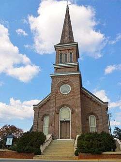 First Presbyterian Church |
November 17, 1983 (#83003489) |
130 North St., E. 33°26′10″N 86°06′03″W |
Talladega | |
| 9 | Goodwin-Hamilton House | 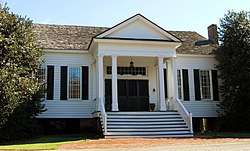 Goodwin-Hamilton House |
August 28, 1986 (#86002041) |
Marble Valley Rd. 33°07′03″N 86°24′46″W |
Sylacauga | |
| 10 | Hightower Brothers Livery Stable | 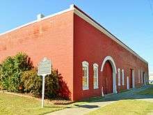 Hightower Brothers Livery Stable |
July 3, 1997 (#97000650) |
413 Norton Ave. 33°10′21″N 86°15′09″W |
Sylacauga | |
| 11 | Idlewild | 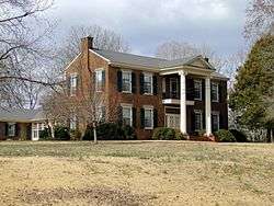 Idlewild |
October 15, 1993 (#93001012) |
State Route 5, 0.1 mi (0.16 km) north of State Route 21 33°28′15″N 86°02′53″W |
Talladega | |
| 12 | Jemison House Complex |  Jemison House Complex |
October 1, 1990 (#90001507) |
South of the junction of Chocolocco and Cheaha Creeks 33°32′02″N 86°02′44″W |
Eastaboga | |
| 13 | Kymulga Mill And Covered Bridge |  Kymulga Mill And Covered Bridge |
October 29, 1976 (#76000356) |
4.5 mi (7.2 km) northeast of Childersburg on State Route 46 33°20′02″N 86°18′00″W |
Childersburg | |
| 14 | Lawler-Whiting House | .jpg) Lawler-Whiting House |
May 22, 1986 (#86001157) |
State Route 21 south of Talladega 33°21′27″N 86°09′56″W |
Talladega | |
| 15 | Silk Stocking District |  Silk Stocking District |
December 13, 1979 (#79000403) |
Roughly bounded by Coffee, 2nd, McMillan, and Court Sts. 33°25′54″N 86°05′54″W |
Talladega | |
| 16 | Dudley Snow House | .jpg) Dudley Snow House |
February 4, 1982 (#82002000) |
Peek Dr. 33°35′01″N 85°48′41″W |
Oxford | Originally located at 704 Snow St. in Calhoun County; moved to current location in the 1990s.[5] |
| 17 | Swayne Hall | 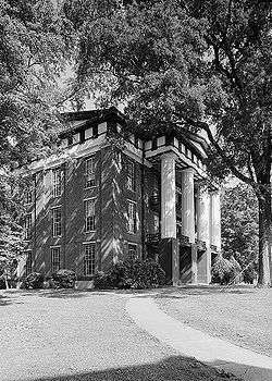 Swayne Hall |
December 2, 1974 (#74002223) |
Talladega College campus 33°26′02″N 86°06′48″W |
Talladega | |
| 18 | Sylacauga Historic Commercial District |  Sylacauga Historic Commercial District |
June 2, 2004 (#04000563) |
Roughly bounded by Broadway Ave., W. 1st., Anniston Ave., and W. 4th St. 33°10′14″N 86°15′08″W |
Sylacauga | |
| 19 | Talladega College Historic District | 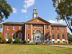 Talladega College Historic District |
August 23, 1990 (#90001316) |
Junction of Battle St. and Martin Luther King Dr. 33°26′00″N 86°06′51″W |
Talladega | |
| 20 | Talladega Courthouse Square Historic District |  Talladega Courthouse Square Historic District |
October 18, 1972 (#72000181) |
Courthouse Sq.; also roughly bounded by N. East, E. North, and S. East, and Coffee and Spring Sts. 33°26′06″N 86°06′09″W |
Talladega | Second set of boundaries represent a boundary increase of June 30, 1988 |
| 21 | Thornhill | .jpg) Thornhill |
February 20, 1998 (#98000104) |
29229 State Route 21 33°24′09″N 86°08′34″W |
Talladega | |
| 22 | William Watters House | September 25, 1987 (#87001652) |
County Highway 8 33°08′33″N 86°24′40″W |
Sylacauga | ||
| 23 | Welch-Averiett House | 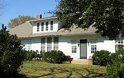 Welch-Averiett House |
August 28, 1986 (#86002044) |
State Route 8 33°08′35″N 86°23′18″W |
Sylacauga | |
| 24 | Winterboro Stagecoach Inn | 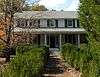 Winterboro Stagecoach Inn |
July 6, 2005 (#05000651) |
22901 State Route 21 33°19′31″N 86°11′49″W |
Winterboro |
See also
| Wikimedia Commons has media related to National Register of Historic Places in Talladega County, Alabama. |
References
- The latitude and longitude information provided in this table was derived originally from the National Register Information System, which has been found to be fairly accurate for about 99% of listings. Some locations in this table may have been corrected to current GPS standards.
- "National Register of Historic Places: Weekly List Actions". National Park Service, United States Department of the Interior. Retrieved on August 14, 2020.
- Numbers represent an ordering by significant words. Various colorings, defined here, differentiate National Historic Landmarks and historic districts from other NRHP buildings, structures, sites or objects.
- The eight-digit number below each date is the number assigned to each location in the National Register Information System database, which can be viewed by clicking the number.
- Tyler, Zach (January 26, 2016). "Restorer of Snow house dead at 93". The Anniston Star. Archived from the original on July 20, 2016. Retrieved July 19, 2016.
Municipalities and communities of Talladega County, Alabama, United States | ||
|---|---|---|
| Cities | Map of Alabama highlighting Talladega County | |
| Towns | ||
| CDPs | ||
| Unincorporated communities | ||
| Ghost town | ||
| Footnotes | ‡This populated place also has portions in an adjacent county or counties | |
This article is issued from Wikipedia. The text is licensed under Creative Commons - Attribution - Sharealike. Additional terms may apply for the media files.