Kalpakanchery
Kalpakanchery is a growing town in Tirur Taluk, Malappuram district, Kerala, India. The village is located 21 kilometres (13 mi) south-west of the city of Malappuram.
Kalpakanchery | |
|---|---|
Village | |
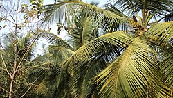 Coconut trees in Kalpakanchery | |

Location in Malappuram district, Kerala | |
| Coordinates: 10.938°N 75.987°E | |
| Country | |
| State | Kerala |
| District | Malappuram |
| Panchayat formation | 10 October 1940[1] |
| Government | |
| • Type | Grama Panchayat |
| • Body | Kalpakanchery Grama Panchayat |
| • President | N. Moideenkutty |
| • Vice president | K. K. Rehna |
| Area | |
| • Total | 16.25 km2 (6.27 sq mi) |
| Population (2011)[2] | |
| • Total | 33,721 |
| • Density | 2,075/km2 (5,370/sq mi) |
| Languages | |
| • Official | Malayalam |
| Human Development | |
| • Sex ratio (2011) | 1191 ♀/1000♂[3] |
| • Literacy (2011) | 94.37%[4] |
| Time zone | UTC+5:30 (IST) |
| PIN | 676551, 676510 |
| Telephone code | 0494 |
| Vehicle registration | KL-55 |
| Nearest towns | |
| Niyamasabha constituency | Tirur |
| Block Panchayat | Kuttipuram |
| Website | www |
Kadungathukundu, Puthanathani, Kurukathani, and Randathani are the four major commercial centres in Kalpakanchery. The village is a centre of academic institutions and other offices. There are several educational institutions, healthcare institutions, two industrial training centres, Kalpakanchery police station, Bafakhy Yatheem Khana (orphanage), post office, Kalpakanchery Sub-registrar Office, and Kalpakanchery Panchayat Office in the town. The village had a weekly market on Wednesdays known as Melangadi Chantha. The weekly market was held in the present-day Melangadi, between Puthanathani and Kadungathukundu. The municipal towns of Tirur, Kottakkal, and Valanchery are located around 8 or 9 kilometres (5.0 or 5.6 mi) away from here. The Kalpakanchery sub-registrar office has obtained ISO standard.[5]
Etymology
The name Kalpakanchery is believed to evolve from the Malayalam words Kalpakam (Coconut tree) and Chery (land) as it was the land of coconut trees.[1]
History
The village was a part of the Kingdom of Tanur (Vettathunad) in medieval times. The Lord of Azhvanchery and Lord of Kalpakanchery were usually present at the coronation of a new Zamorin of Calicut. It is believed that the soldiers of Tipu Sultan had tented at Nadayalparamba and Cholakamad in Kalpakanchery during the Mysorean invasion of Malabar. Some 20,000 people attended a Khilafat Movement meeting held in Kalpakanchery just before the 1921 Malabar rebellion. During the uprising, a gang under the leadership of Odayappurath Chekkutty from Kalpakanchery guarded the Kizhake Kovilakam and the Arya Vaidya Sala at Kottakkal. The Kalpakanchery Gram Panchayat was formed on 10 October 1940, as a part of the British Malabar.[1]
Demography
As of the 2011 India census, Kalpakanchery had a population of 33,721 with 15,391 males and 18,330 females.[6]. The literacy rate of the village in 2011 was 94.37%.[4] Malayalam is the most spoken language.
Education

Kadungathukundu is an educational hub of the village. As of 2011 census, the village contains 2 pre-primary schools, 13 primary schools, 5 middle schools, 3 secondary schools, 3 senior secondary schools, 3 vocational training schools, a special school for disabled, and one more school[7]. The GMLPS Paleth, being established in 1902, is one of the oldest primary schools in Malappuram district, and the GVHSS Kalpakanchery, being established in 1920, is one of the oldest secondary schools in the Malappuram district. Some of the major educational institutions in the village are:
| Name | Type | Sector |
|---|---|---|
| BYKAS College for Women, Kalpakanchery[8] | Arts&Science College | Private |
| Bafakhy ITI college, Kadungathukundu[9] | Industrial Training Institute | Private |
| Amina ITI college, Kadungathukundu[10] | Industrial Training Institute | Private |
| BYK B.Ed. Training College, Kadungathukundu[11] | Professional College | Private |
| GVHSS, Kalpakanchery | Higher Secondary School | Govt. |
| MSMHSS, Kallingalparamba | Higher Secondary School | Aided |
| BYKRHS, Kadungathukundu | High school | Private |
| GUPS, Randathani | Primary school | Govt. |
| Rahmani Primary School, Randathani | Primary school | Private |
| Najath Public School, Randathani | Primary school | Private |
| GMLPS, Paleth | Primary school | Govt. |
| GMLPS, Parapuram | Primary school | Govt. |
| GMPLS, Paravannur | Primary school | Govt. |
| AMLPS, Paravannur | Primary school | Aided |
| GMLPS, Ayirani | Primary school | Govt. |
| AMLPS, Thozhanur west | Primary school | Aided |
| AMLPS, Thozhanur east | Primary school | Aided |
| GLPS, Kalpakanchery | Primary school | Govt. |
| GMLPS, Manjachola | Primary school | Govt. |
| GMLPS, Kananchery | Primary school | Govt. |
Health
As of 2011 census, there is a Primary health centre, 3 primary health subcentres, a maternity and child welfare centre, 2 hospital alternative medicines, a dispensary, 2 veterinary hospitals, a family welfare centre, 2 charitable private hospitals, and 12 medicinal shops in the village.[7]
A government Ayurvedic hospital and a government veterinary dispensary functions at Thozhanur near to Randathani.
Local administration
The region is administered by the Kalpakanchery Grama Panchayat. It is composed of 19 wards:[12]
| Ward | Name | Party | Alliance | Member |
|---|---|---|---|---|
| 1 | Parapuram | IUML | UDF | Ilyas |
| 2 | Variyath | IUML | UDF | Fainusha Thachaparambil |
| 3 | Randathani | IUML | UDF | Rasheeda Kaladi |
| 4 | Kizhakepuram | IUML | UDF | Sulaikha |
| 5 | Tharalad | Ind. | UDF | T. P. Noushad |
| 6 | Manjachola | Ind. | UDF | Kadeeja Pachiyath |
| 7 | Kallingal | IUML | UDF | Saidalikutty T. P. |
| 8 | Paravannur Chola | IUML | UDF | Zainul Abideen C. |
| 9 | Padathepeedika | Ind. | LDF | Fathima |
| 10 | Paravannur | IUML | UDF | Rehna K. K. |
| 11 | Ayirani | Ind. | LDF | Mohamed Shareef |
| 12 | Kadungathukundu | INC | UDF | K. C. Sreedharan |
| 13 | Kalpakanchery | IUML | UDF | K. Moideenkutty |
| 14 | Thottayi | IUML | UDF | Jubairiya |
| 15 | Kananchery | Ind. | LDF | Shaharbanu |
| 16 | Paleth | Ind. | LDF | Pilakkal Anwar Sadath |
| 17 | Varambingal | IUML | UDF | Mariyamu |
| 18 | Kallingalparamba | IUML | UDF | N. Moideenkutty |
| 19 | Kundamchina | Ind. | UDF | Naseema P. T. |
Law and Order
The Kalpakanchery police station consists of seven villages namely Kalpakanchery, Valavannur, Ponmundam, Cheriyamundam, Perumanna-Klari, Athavanad, and Tirunavaya. The station was established in 1919. It comes under the jurisdiction of the Tirur court.[13] M. Mohammed Haneefa is the present Inspector of Kalpakanchery police station.[14]
Connectivity
- Railway Station: The Tirur railway station is just 10 kilometres (6.2 mi) away from the town. Almost every train stops here.
- Road: Kalpakanchery is well connected to the other cities by road, National Highway-66 passes through the town. There are regular buses plying to other cities including Malappuram, Kozhikode, Kochi, Thrissur, and Coimbatore. There are a few private buses offering over night journeys to Bangalore, Trivandrum, and Coimbatore.
- Nearest Airport: The Karipur International Airport is approximately 30 kilometres (19 mi) away.
Sports
The Paravannur Mini-stadium is the largest stadium in the village.
Notable people
- Azad Moopen
- Odayappurath Chekkutty
References
- "History of Kalpakanchery". lsgkerala.in. Retrieved 15 July 2020.
- Directorate of Census Operations, Kerala. District Census Handbook, Malappuram (PDF). Thiruvananthapuram: Directorate of Census Operations, Kerala. p. 172. Retrieved 14 July 2020.
- Directorate of Census Operations, Kerala. District Census Handbook, Malappuram (PDF). Thiruvananthapuram: Directorate of Census Operations, Kerala. p. 350. Retrieved 14 July 2020.
- Directorate of Census Operations, Kerala. District Census Handbook, Malappuram (PDF). Thiruvananthapuram: Directorate of Census Operations, Kerala. p. 351. Retrieved 14 July 2020.
- Express News Service (19 February 2020). "Sub registrar offices to be of ISO standards". New Indian Express. New Indian Express. Retrieved 15 July 2020.
- "2011 Census India, Malappuram District" (PDF). censusindia.gov.in.
- Directorate of Census Operations, Kerala. District Census Handbook, Malappuram (PART-A) (PDF). Trivandrum: Directorate of Census Operations, Kerala. pp. 168–169. Retrieved 14 July 2020.
- "BYKAS College for Women, Kalpakanchery".
- "Bafakhy ITI college, Kadungathukundu".
- "Amina ITI college, Kadungathukundu".
- "BYK B.Ed. Training College, Kadungathukundu".
- "Members of Kalpakanchery Grama Panchayath since 2015 Kerala local body elections". lsgkerala.gov.in.
- "Jurisdiction of Kalpakanchery Police Station". malappuram.keralapolice.gov.in.
- "Inspector of police". malappuram.keralapolice.gov.in. Retrieved 15 July 2020.
External links
| Wikimedia Commons has media related to Kalpakanchery. |
Places adjacent to Kalpakanchery | ||||||||||
|---|---|---|---|---|---|---|---|---|---|---|
| ||||||||||
- "dchb malappuram" (PDF). censusindia.gov.in.