Edakkara
Edakkara is a town located in the Malappuram district of the Indian state of Kerala.
Edakkara | |
|---|---|
village | |
 Edakkara | |
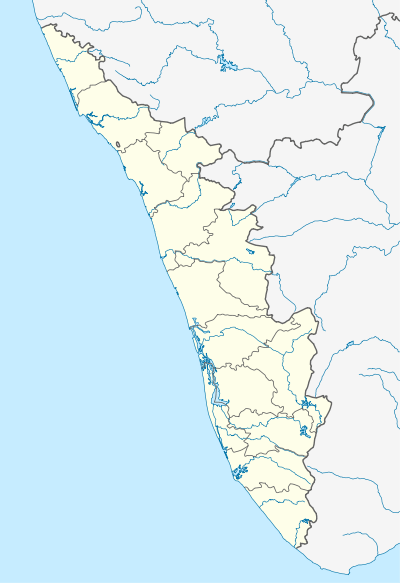 Edakkara Location in Kerala, India  Edakkara Edakkara (India) | |
| Coordinates: 11.35695°N 76.305263°E | |
| Country | |
| State | Kerala |
| District | Malappuram |
| Population | |
| • Total | 24,490 |
| Languages | |
| • Official | Malayalam, English |
| Time zone | UTC+5:30 (IST) |
| Telephone code | 04931 |
| Vehicle registration | KL-71 |
| Website | http://lsgkerala.in/edakkarapanchayat/ |
Location
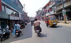
Edakkara is located near Nilambur, Malappuram District, in Kerala State. It is 15 km from Nilambur and about 37 km apart from Gudallur on the Ooty Guruvayoor State Highway 17 between Gudallor and Manjeri. The town is emerging as a hub in the East Eranad region within the Nilambur Taluk and Malappuram districts.[1]
The town faces mountainous areas to its east.[1]
Name
Edakkara got its name said to have from a Malayalam word "Edathavalam" it means a place where somebody stays for rest . So in the end the place got its name as Edakkara.[2]
History
Years ago Edakkara was a place for resting those who were traveling to Kozhikode to Ooty. The place is said to have got its name from a Malayalam word; "Edathavalam" which means a place where somebody stays for rest. So in the end the place got its name as Edakkara. Another story widely believed is that it is a place between two rivers, Chaliyar and Punnapuzha. It is very hard to trace the history of nomenclature of this place.
Edakkara’s history is intertwined with the history of Nilambur Kovilakkam. Their land was divided into 18 Cherikkals (similar to today's ward system). Edakkara panchayath was in East cherikkal. That time people were forest dwellers; they were Malamuthar, Cholanaykkar, Malanaykkar, Aranadar, Paniyar, Kuruvar. Their main income came from the forest. Muslims migrated to Edakkara for cutting trees and to collect bamboos from the forest. At about the same time Nair and Theyyer sects also migrated to Edakkara for agriculture. People still believe that they started cultivating plants.
People who migrated to Edakkara followed the rules and regulations of thamburan (Ruler of the Nilambur) of Nilambur Kovilakam in spite of the religious and cultural differences. An increase in agricultural production brought other professionals to this land. They were blacksmiths, carpenters and workers for land cultivation. In 1920 Edakkara became a migrator's heaven. First Edakkara public school was established in 1932. Edakkara High become one of the best government schools in Malappuram. Ayurvedic healing system and food distribution and health specialty center for maternity and child welfare was really helpful for the society. Meanwhile, Raja Lakshmi buses started bus service via Kozhikode-Ooty road which was built by the British government.
After India’s Independence people started to migrate here from Thiruvathamkoor; it was an exodus actually. Instead of police station a police outpost was started in May–June 1964. Edakkara post office’s inception was in 1940. Navodhaya library still plays a pivotal role in Edakkara culture which was started in 1957. Edakkara village was formed during 1963-1964. Health centre, Registration office and Electricity office became a reality in 1981. A small L P school which started in 1963 became a big private institution with several courses still functioning well by the name of Sree Vivekanadha in Palemadu.
1963 is the memorable year of Edakkara Panchayath because of its first election. Savious master became the first President. Vazhikkadavu Panchayath was formed by dividing Edakkara Panchayath in 1969. In 1978 it divided again and Moothedam Panchayath became a reality. Today Mr. O T James is the president and Mrs Sareena Muhammed is the vice president.
Suburbs of Edakkara
- Karimpuzha, Valuvassery and Chungathara
- Palunda, Musliyarangady and Palathingal
- Palad and Nellikuth
- Moothedam, Palankara
- Palemad, Karunechi, Aranadampadam, Samkaramkulam
Transportation
The town has bus services to four nearby panchayats (Vazhikadavu, Moothedam, Pothukallu and Marutha), and to most districts in Kerala, Mysore, Bangalore and Ooty.
Two bus stations serve Edakkara. Many minibuses connect Edakkara to towns such as Barbarmukk, Karunnechi, Palemad, Marutha, and Shankaramkulam. It is also a stop for Super-Fast Buses that connect the area with Nilambur, Manjeri, Calicut and Perinthalmanna.
Also you get Train From Railway station Nilambur Road which is 14Km only From Edakkara
Governance
It is administered under the Wayanad Loksabha constituency. A circle office and police station situated in Edakkara.
The Panchayat President is Srmt Alis Ambat .
Economy
Trade is the primary occupation, especially in textiles, groceries and automobiles. Rubber and pepper are the primary crops along with rice and coconut. Remitted income from Persian Gulf countries has supported the development of Edakkara.
Shopping mall named Dubai Mall is located in edakkara main road , opposite to police station Road , with lot of spaces for shopping, and with spacious parking. Which is going to change the face of edakkara in near by future. Already there is coffee shop, sports shop , gents shop , stationary shops and mobile shop.
The Government High School is situated in the heart of Edakkara. The other schools in and near Edakkara include the Guidance public school.
Eranad Hospital is the most developed Hospital. Upcoming shopping mall in heart of the town also create big hike in economy of edakkara, and also trying to change digitalised transactions
Religious Places
Four temples, the Sree Krishna Temple and Durgha Devi Kshethram are situated in Edakkara Town and two ayyappa temples - one at Kawkkad and another at palemad. Four mosques, one in Musliyarangadi (the first mosque in Edakkara), one on Post Office Road, one School Road and one on KPM General Hospital Road. Many churches including St.Thomas Catholic Church in Palemad, St.George Malankara Church in Muppini, Emmanuel Marthoma Church and Brethren Church in Munda and other Evangelical churches.
Education
- SVVHSS Palemad, Situated at Palemad, a small village 4 km away from Edakkara town
- Govt HSS Edakkara
Transportation
Edakkara town connects to other parts of India through Nilambur town. State Highway No.28 starts from Nilambur and connects to Ooty, Mysore and Bangalore through Highways.12,29 and 181. National highway No.66 passes through Ramanattukara and the northern stretch connects to Goa and Mumbai. The southern stretch connects to Cochin and Trivandrum. State. The nearest airport is at Kozhikode.
See also
- Nilambur town
- Vazhikkadavu border town
- Gudalur
- Mango Orange village
- Pandalur town
- Devala, Nilgris
- Nilambur-Shoranur railway line
| Wikimedia Commons has media related to Vazhikkadavu. |
References
- "dchb malappuram" (PDF). censusindia.gov.in.