Abdu Rahiman Nagar
Abdu Rahiman Nagar is a census town in Malappuram district in the state of Kerala, India. It is also the name of a Grama Panchayat.[1]
Abdul Rahiman Nagar Kolappuram A.R. Nagar | |
|---|---|
Census town | |
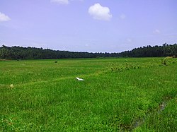 Pottanil paddy fields | |
| Coordinates: 11.074450°N 75.9368600°E | |
| Country | |
| State | Kerala |
| District | Malappuram |
| Population (2001) | |
| • Total | 35,534 |
| Languages | |
| • Official | Malayalam, English |
| Time zone | UTC+5:30 (IST) |
| PIN | 6763xx |
| Vehicle registration | KL- |
| Website | www |
Demographics
As of 2001 India census, Abdu Rahiman Nagar had a population of 35534 with 17262 males and 18272 females.[1]
Etymology
The name Abdu Rahiman Nagar came from the name of freedom fighter Mohammed Abdul Rahiman.
Culture
A.R.Nagar village is a predominantly Muslim populated area So the culture of the locality is based upon Muslim traditions. . People gather in mosques for the evening prayer and continue to sit there after the prayers discussing social and cultural issues. Business and family issues are also sorted out during these evening meetings. The Hindu minority of this area keeps their rich traditions by celebrating various festivals in their temples. Hindu rituals are done here with a regular devotion like other parts of Kerala.[2]
Transportation
A.R.Nagar village connects to other parts of India through Parappanangadi town. National highway No.66 passes through A.R.Nagar and the northern stretch connects to Goa and Mumbai. The southern stretch connects to Cochin and Trivandrum. State Highway No.28 starts from Nilambur and connects to Ooty, Mysore and Bangalore through Highways.12,29 and 181. The nearest airport is at Kozhikode. The nearest major railway station is at Parappanangadi.
References
- "Census of India : Villages with population 5000 & above". Registrar General & Census Commissioner, India. Archived from the original on 8 December 2008. Retrieved 10 December 2008.
- "Archived copy". Archived from the original on 1 April 2016. Retrieved 14 July 2016.CS1 maint: archived copy as title (link)
Image Gallery
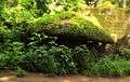 Kodakallu in AR Nagar
- "dchb malappuram" (PDF). censusindia.gov.in.