Añasco, Puerto Rico
Añasco (Spanish pronunciation: [aˈɲasko]), named after one of its settlers, Don Luis de Añasco, is a municipality of Puerto Rico located on the west coast of the island bordering the Mona Passage to the west, north of Mayagüez, and Las Marias; south of Rincón, Aguada, and Moca and west of San Sebastián and Las Marias. It is part of the Aguadilla-Isabela-San Sebastián Metropolitan Statistical Area.
Añasco | |
|---|---|
City and Municipality | |
 Puente Salcedo de Añasco | |
 Flag | |
| Nicknames: "La Ciudad Donde los Dioses mueren", "El Pueblo Del Hojaldre", "El Pueblo de los Morcilleros", "Los nativos" | |
| Anthem: "Añasco pueblo querido..." | |
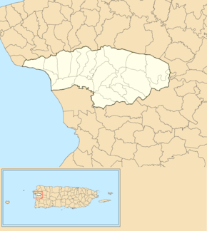
 Map of Puerto Rico highlighting Añasco Municipality | |
| Coordinates: 18°18′58″N 67°08′23″W | |
| Commonwealth | |
| Founded | October 18, 1733 |
| Wards | |
| Government | |
| • Mayor | Jorge Estévez Martínez (PPD) |
| • Senatorial dist. | 4 - Mayagüez |
| • Representative dist. | 17 |
| Area | |
| • Total | 35.5 sq mi (92 km2) |
| Population (2010) | |
| • Total | 29,261 |
| • Density | 820/sq mi (320/km2) |
| Demonym(s) | Añasqueños |
| Time zone | UTC−4 (AST) |
| ZIP Code | 00610 |
| Area code(s) | 787/939 |
| Major routes | |
| Website | www |
History
The town was founded on October 18, 1733 and named after Don Luis de Añasco, a colonist from the Extremadura region of Spain who came to Puerto Rico with Juan Ponce de León. Añasco was founded by the initiative of rich landowner Don José de Santiago, who wanted to establish the villa in properties owned by Don Luis de Añasco. The property was located on the margins of the río Guaorabo, as the Taínos called it.[1]
Añasco town was preceded by the first settlement of San Germán. In November 1511, Juan Ponce de León handed over governorship to Juan Cerón, a lieutenant of the viceroy Diego Colon (son of Cristobal Colon or Cristopher Columbus). Cerón ordered Miguel de Toro, a lieutenant of Juan Ponce de León, to create a "Christian Village" in western Borinquen, calling it San Germán. This was the second attempt of foundation given in 1511 at the mouth of the Guaorabo River (present day Rio Añasco), near the area known today as Añasco, Puerto Rico. This first settlement was attacked in 1528, 1538, and again in 1554. A fort to protect this town began in 1540, but its construction was suspended in 1546 when the people decided to move inland being tired of attacks. Attacks by Carib Indians forced the population to move south inland to the present site of the present town of San Germán.
In the 18th century, Añasco was the fourth most populous municipality in Puerto Rico, after San Germán, San Juan, and others. The Añasco River is also claimed to be the site of the popular legend of the drowning of the Spaniard Diego Salcedo in 1511 at the hands of the Taínos, proving the Spanish soldiers were not gods and igniting a revolt. It is believed that the revolt was led by the cacique Chayoán and suppressed by Spanish soldiers.
Many of the first settlers to the area came from the Canary Islands and the south of Spain. The 1918 San Fermín earthquake destroyed Añasco's parish church, the town hall and other buildings, almost eliminating most of the historic downtown structures.
Hurricane Maria
Hurricane Maria on September 20, 2017 triggered numerous landslides in Añasco. In some areas of Añasco there were more than 25 landslides per square mile due to the significant amount of rainfall.[2][3]
Geography
Añasco is located in the Coastal Plains of the west, bordered by the Río Grande de Añasco. It is bordered in the north by Rincón, Aguada, and Moca; Mayagüez to the south; and San Sebastián and Las Marías to the east. The Mona Passage lies to the west of the town.[4] The Añasco terrain is mostly plain, but features a series of hills and mountains like Canta Gallo (1,194 feet, or 364 meters), Gordo and Pichón (both at 1,115 feet, or 340 meters).[5] It is also crossed by several rivers like Icaco River, Caguabo River, La Balsa, and others.[4][6]
Barrios
Like all municipalities of Puerto Rico, Añasco is subdivided into barrios. The municipal buildings, central square and large Catholic church are located in a small barrio referred to as "el pueblo", near the center of the municipality.[7][8][9][10]
Sectors
Barrios (which are like minor civil divisions)[11] in turn are further subdivided into smaller local populated place areas/units called sectores (sectors in English). The types of sectores may vary, from normally sector to urbanización to reparto to barriada to residencial, among others.[12][13][14]
Special Communities
Of the 742 places on the list of Comunidades Especiales de Puerto Rico, the following barrios, communities, sectors, or neighborhoods are in Añasco: Cerro Gordo, Corcovada, Hatillo, Miraflores, and Caguabo barrios, Comunidad La Playa, Parcelas Josefa (Comunidad Espino), Parcelas Marías, Piñales (La Choza), and Zumbadora sector in Río Arriba barrio.[15]
Demographics
Like most of the people of Puerto Rico, the Añasco population originated with the Taino Indians and then by immigrants from Spain that settled the central highland, most prominently the Andalusian and Canarian Spanish migration who formed the bulk of the jibaro or white peasant stock of the island.[16] The Andalusian and Canarian Spaniards also influenced much of the Puerto Rican culture which explains the Southern Spanish dialect, and the Spanish colonial architecture. This area of the Island has an array of cultures that include the Basque, French, Corsican and Italian is highly predominant due to the introduction of coffee in this region of the Island.
The United States took control of Puerto Rico from Spain in the aftermath of the Spanish-American War under the terms of the Treaty of Paris of 1898 and conducted its first U.S. census of Puerto Rico, finding that the population of Añasco was 13,311.
| Historical population | |||
|---|---|---|---|
| Census | Pop. | %± | |
| 1900 | 13,311 | — | |
| 1910 | 14,407 | 8.2% | |
| 1920 | 13,834 | −4.0% | |
| 1930 | 14,276 | 3.2% | |
| 1940 | 15,701 | 10.0% | |
| 1950 | 17,235 | 9.8% | |
| 1960 | 17,200 | −0.2% | |
| 1970 | 19,416 | 12.9% | |
| 1980 | 23,274 | 19.9% | |
| 1990 | 25,234 | 8.4% | |
| 2000 | 28,348 | 12.3% | |
| 2010 | 29,261 | 3.2% | |
| U.S. Decennial Census[17] 1899 (shown as 1900)[18] 1910-1930[19] 1930-1950[20] 1960-2000[21] 2010[9] | |||
Tourism

Landmarks and places of interest
There are 18 beaches in Añasco.[22] Tres Hermanos Beach is a well-known Añasco beach[23] which remained closed for more than two years after Hurricane Maria destroyed it in September 2017. It was set to reopen in 2020 after many renovations which continued into February 2020.[24] Some other beaches and places of interest of Añasco include:
- Añasco Beach
- Autodrome
- El Salto de la Encantada
- Hacienda La Eugenia
- Río Grande de Añasco
- San Antonio Abad Parish Church
- Villa Pesquera
Culture
Festivals and events
Añasco celebrates its patron saint festival in January. The Fiestas Patronales de San Antonio Abad is a religious and cultural celebration that generally features parades, games, artisans, amusement rides, regional food, and live entertainment.[4][25]
Other festivals and events celebrated in Añasco include:
- Mayuco Festival – January
- Fine Arts Festival (Festival de Bellas Artes – January
- Three Kings Day Festival in Ovejas and Corcovada wards – January
- Saint Anthony’s Marathon – January
- Antique Car Fair – January
- Theater Festival – May
- Youth Festival – July
- Festival in Honor of Saint Rose of Lima – August
- Añasco Triathlon – September
- Chipe Festival – October
Sports
Añasco has a AA baseball team called the Fundadores de Añasco.[26] It is also known for being the hometown of some amateur boxing prospects like Samuel Figueroa.[27]
Notable People
- Mariana Bracetti - (1825–1903) was a patriot and leader of the Puerto Rico independence movement in the 1860s. She is attributed with having knitted the flag that was intended to be used as the national emblem of Puerto Rico in its attempt to overthrow the Spanish government on the island, and to establish the island as a sovereign republic.
- Ivy Queen - Singer
- Aristides Gonzalez - boxer, Olympic bronze medalist in 1984
Economy
Government
All municipalities in Puerto Rico are administered by a mayor, elected every four years. The current mayor of Añasco is Jorge Estévez Martínez, of the Popular Democratic Party (PPD). He was elected at the 2008 general elections and is currently serving his third term.
The city belongs to the Puerto Rico Senatorial district IV, which is represented by two Senators. In 2016, Luis Daniel Muñiz Cortés and Evelyn Vázquez were elected as District Senators.[28]
Transportation
There are 22 bridges in Añasco.[29]
Education
The Puerto Rico Department of Education operates several public schools in the municipality, including two bilingual schools, Antonio Gonzalez Suarez Regional Bilingual Elementary School and Sergio Ramirez de Arellano-Hostos Regional Bilingual Secondary School, the first public bilingual schools on the island. There's also private bilingual schools in the municipality, such as Colegio de la Salle and MAS Integrated School.
Symbols
Flag
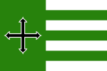
The flag colors, design and symbolism is taken from the Añasco's coat of arms, with the only exception the silver parts on the coat of arms are white on the flag.[1]
Coat of arms
The green field of the shield contains a saber cross massed in black, outlined in silver, and has a gold scallop shell in each quadrant formed by the cross. A gold mural crown of three towers crests the shield.[1]
See also
- History of Puerto Rico
- National Register of Historic Places listings in Añasco, Puerto Rico
References
- "Añasco Municipality Founding History and Symbols". enciclopediapr.org. Fundación Puertorriqueña de las Humanidades (FPH). Archived from the original on 14 February 2019. Retrieved 14 February 2019.
- "Preliminary Locations of Landslide Impacts from Hurricane Maria, Puerto Rico". USGS Landslide Hazards Program. USGS. Archived from the original on 2019-03-03. Retrieved 2019-03-03.
- "Preliminary Locations of Landslide Impacts from Hurricane Maria, Puerto Rico" (PDF). USGS Landslide Hazards Program. USGS. Archived (PDF) from the original on 2019-03-03. Retrieved 2019-03-03.
- "Añasco Municipality General Info (Location, Square Miles, Economy and Geography)". enciclopediapr.org. Fundación Puertorriqueña de las Humanidades (FPH). Archived from the original on 14 February 2019. Retrieved 14 February 2019.
- Cerro Canta Gallo, Puerto Rico Archived 2012-04-05 at the Wayback Machine on Lat-Long
- Municipios: Añasco Archived 2010-11-23 at the Wayback Machine on Enciclopedia de Puerto Rico
- Picó, Rafael; Buitrago de Santiago, Zayda; Berrios, Hector H. Nueva geografía de Puerto Rico: física, económica, y social, por Rafael Picó. Con la colaboración de Zayda Buitrago de Santiago y Héctor H. Berrios. San Juan Editorial Universitaria, Universidad de Puerto Rico,1969. Archived from the original on 2018-12-26. Retrieved 2018-12-30.
- Gwillim Law (20 May 2015). Administrative Subdivisions of Countries: A Comprehensive World Reference, 1900 through 1998. McFarland. p. 300. ISBN 978-1-4766-0447-3. Retrieved 25 December 2018.
- Puerto Rico:2010:population and housing unit counts.pdf (PDF). U.S. Dept. of Commerce, Economics and Statistics Administration, U.S. Census Bureau. 2010. Archived (PDF) from the original on 2017-02-20. Retrieved 2018-12-30.
- "Map of Añasco at the Wayback Machine" (PDF). Archived from the original (PDF) on 2015-04-17. Retrieved 2018-12-29.
- "US Census Barrio-Pueblo definition". factfinder.com. US Census. Archived from the original on 13 May 2017. Retrieved 5 January 2019.
- "Agencia: Oficina del Coordinador General para el Financiamiento Socioeconómico y la Autogestión (Proposed 2016 Budget)". Puerto Rico Budgets (in Spanish). Retrieved 28 June 2019.
- Rivera Quintero, Marcia (2014), El vuelo de la esperanza: Proyecto de las Comunidades Especiales Puerto Rico, 1997-2004 (first ed.), San Juan, Puerto Rico Fundación Sila M. Calderón, ISBN 978-0-9820806-1-0
- "Leyes del 2001". Lex Juris Puerto Rico (in Spanish). Retrieved 24 June 2020.
- Rivera Quintero, Marcia (2014), El vuelo de la esperanza:Proyecto de las Comunidades Especiales Puerto Rico, 1997-2004 (Primera edición ed.), San Juan, Puerto Rico Fundación Sila M. Calderón, p. 273, ISBN 978-0-9820806-1-0
- Hernández, Miguel. "Brief History of the Canarian Migration to Spanish America". Puerto Rican Hispanic Genealogical Society. RootsWeb.com. Archived from the original on 2015-04-18. Retrieved 2014-12-09.
- "U.S. Decennial Census". United States Census Bureau. Archived from the original on February 13, 2020. Retrieved September 21, 2017.
- "Report of the Census of Porto Rico 1899". War Department, Office Director Census of Porto Rico. Archived from the original on July 16, 2017. Retrieved September 21, 2017.
- "Table 3-Population of Municipalities: 1930, 1920, and 1910" (PDF). United States Census Bureau. Archived (PDF) from the original on August 17, 2017. Retrieved September 21, 2017.
- "Table 4-Area and Population of Municipalities, Urban and Rural: 1930 to 1950" (PDF). United States Census Bureau. Archived (PDF) from the original on August 30, 2015. Retrieved September 21, 2014.
- "Table 2 Population and Housing Units: 1960 to 2000" (PDF). United States Census Bureau. Archived (PDF) from the original on July 24, 2017. Retrieved September 21, 2017.
- "Las 1,200 playas de Puerto Rico [The 1200 beaches of Puerto Rico]". Primera Hora (in Spanish). April 14, 2017. Archived from the original on December 12, 2019. Retrieved December 12, 2019.
- "Tres Hermanos, Añasco - Ruta Marina | EnciclopediaPR". Archived from the original on 2019-07-15. Retrieved 2019-07-15.
- https://www.wipr.pr/reabriran-balneario-tres-hermanos-de-anasco-tras-destruccion-de-maria/
- "Puerto Rico Festivales, Eventos y Actividades en Puerto Rico". Puerto Rico Hoteles y Paradores (in Spanish). Retrieved 2020-07-17.
- "San Sebastián avanza por primera vez desde 2013 al Carnaval de Campeones" (in Spanish). June 23, 2019.
- https://boxrec.com/en/proboxer/584846
- Elecciones Generales 2012: Escrutinio General Archived November 27, 2012, at the Wayback Machine on CEEPUR
- "Anasco Bridges". National Bridge Inventory Data. US Dept. of Transportation. Archived from the original on 20 February 2019. Retrieved 19 February 2019.
External links
| Wikivoyage has a travel guide for Añasco. |
- Añasco coastline on Gettyimages
- The City of Añasco on Facebook
- Welcome to Puerto Rico! Añasco
- "Añasco, Puerto Rico". Geographic Names Information System. United States Geological Survey. Retrieved 2008-05-07.