Arroyo, Puerto Rico
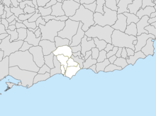
Arroyo (Spanish pronunciation: [aˈroʝo]) is a municipality located along the southern coast of Puerto Rico and bordered by the Caribbean Sea, east of the municipality of Guayama and northwest of the municipality of Patillas. Arroyo is spread over 5 wards and Arroyo Pueblo (the downtown area and administrative center). It is part of the Guayama Metropolitan Statistical Area.
Arroyo | |
|---|---|
Town and Municipality | |
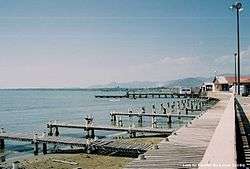 Malecón de Arroyo | |
 Flag 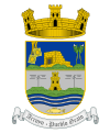 Coat of arms | |
| Nicknames: "Pueblo Grato" "Los Bucaneros" | |
| Anthem: "Arroyo" | |
 Map of Puerto Rico highlighting Arroyo Municipality | |
| Coordinates: 17°57′57″N 66°03′41″W | |
| Commonwealth | |
| Founded | December 25, 1855 |
| Wards | |
| Government | |
| • Mayor | Eric Bachier Román (PDP) |
| • Senatorial dist. | 6 - Guayama |
| • Representative dist. | 30 |
| Area | |
| • Total | 23.0 sq mi (59.6 km2) |
| • Land | 15 sq mi (39 km2) |
| • Water | 8.0 sq mi (20.6 km2) |
| Population (2010) | |
| • Total | 19,117 |
| • Density | 830/sq mi (320/km2) |
| Demonym(s) | Arroyanos |
| Time zone | UTC−4 (AST) |
| ZIP Code | 00714 |
| Area code(s) | 787/939 |
| Major routes | |
| Website | www |
History
The town of Arroyo was officially founded on December 25, 1855. However, it is believed that there were previous settlements on the area even previous to the Spanish colonization. It is believed that the name of Arroyo (which means "creek" in English) is derived from a small water stream where travelers stopped to freshen up before continuing on their way.[1]
It has been said that the town came to be formed when a small group of people from the neighbor town of Guayama came to the region looking for a port to export and import merchandise. Still, a local newspaper called La Gaceta de Puerto Rico published in 1868 that Arroyo was founded in 1852. Between 1859 and 1860, City Hall signed agreements to open streets and build a town square and a sewer system for the town.
In 1858, Samuel Morse introduced wired communication to Latin America when he established a telegraph system in Puerto Rico, then a Spanish Colony. Morse's oldest daughter Susan Walker Morse (1821–1885), would often visit her uncle Charles Pickering Walker who owned the Hacienda Concordia in the town of Guayama. During one of her visits she met and later married Edward Lind, a Danish merchant who worked in the Hacienda La Henriqueta in Arroyo.[2] Lind purchased the Hacienda from his sister when she became a widow. Morse, who often spent his winters at the Hacienda with his daughter and son-in-law, set a two-mile telegraph line connecting his son-in-law's Hacienda to their house in Arroyo. The line was inaugurated on March 1, 1859 in a ceremony flanked by the Spanish and American flags.[3][4] The first lines transmitted by Samuel Morse that day in Puerto Rico were:[2]
"Puerto Rico, beautiful jewel! When you are linked with the other jewels of the Antilles in the necklace of the world's telegraph, yours will not shine less brilliantly in the crown of your Queen!"
When after the Treaty of Paris (1898), the U.S. conducted its first census of Puerto Rico, the population of Arroyo was 4,867.[5]
In 1902, Puerto Rico's Legislative Assembly approved a law to consolidate certain municipalities. According to it, Arroyo would be merged with Guayama starting in July 1 of that year. However, the law was revoked in 1905 returning Arroyo to its municipal status.
In early 1999, the U.S. Congressional record documented a commendation of Arroyo, on its 100-year relationship with the U.S., noting that many citizens of Arroyo have fought and died in wars for the U.S., such as Virgilio Sánchez and Raul Serrano.[6]
Geography
Arroyo belongs to the alluvial plains sub-region of Ponce-Patillas known as the Southern Coastal Valley. The area is very dry although its plains are productive thanks to artificial irrigation.[7]
Hurricane Maria
On September 20, 2017, Hurricane Maria triggered numerous landslides in Arroyo with the significant amount of rainfall.[8][9]
Barrios
Like all municipalities of Puerto Rico, Arroyo is subdivided into barrios. The municipal buildings, central square and large Catholic church are located in a small barrio referred to as "el pueblo", near the center of the municipality.[10][11][12]
Sectors
Barrios (which are like minor civil divisions)[13] in turn are further subdivided into smaller local populated place areas/units called sectores (sectors in English). The types of sectores may vary, from normally sector to urbanización to reparto to barriada to residencial, among others.[14][15][16]
Special Communities
Of the 742 places on the list of Comunidades Especiales de Puerto Rico, the following barrios, communities, sectors, or neighborhoods are in Arroyo: the Marín neighborhood, Palmas barrio, Yaurel barrio, and the San Felipe-Arizona zone.[17]
Water features
The Nigua River crosses the municipality from north to south. Its hydrographic system is completed by a series of smaller rivers. There is also a mineral water spring in the Virella Colony.[7]
Demographics
The United States took control of Puerto Rico from Spain in the aftermath of the Spanish-American War under the terms of the Treaty of Paris of 1898 and conducted its first census of Puerto Rico, finding that the population of Arroyo was 4,867.
| Historical population | |||
|---|---|---|---|
| Census | Pop. | %± | |
| 1900 | 4,867 | — | |
| 1910 | 6,940 | 42.6% | |
| 1920 | 7,074 | 1.9% | |
| 1930 | 8,199 | 15.9% | |
| 1940 | 10,746 | 31.1% | |
| 1950 | 12,936 | 20.4% | |
| 1960 | 13,315 | 2.9% | |
| 1970 | 13,033 | −2.1% | |
| 1980 | 17,014 | 30.5% | |
| 1990 | 18,910 | 11.1% | |
| 2000 | 19,117 | 1.1% | |
| 2010 | 19,575 | 2.4% | |
| U.S. Decennial Census[18] 1899 (shown as 1900)[19] 1910-1930[20] 1930-1950[21] 1960-2000[22] 2010[11] | |||
Tourism
.jpg)
Landmarks and places of interest
There are eight beaches in Arroyo.[23]
Among the places of interest in Arroyo are the Enrique Huyke Monument, dedicated to the educator and athlete, and the Samuel Morse Monument, dedicated to the American inventor of the telegraph. Casa de Aduana is a museum located in Arroyo.[24]
Other landmarks are La Cora Hacienda, Las Palmas Beach,[25] Punta Guilarte,[26] Punta de Las Figuras Lighthouse and the Arroyo Sugar Cane Train.[27]
Culture
Festivals and events
Arroyo celebrates its patron saint festival in July. The Fiestas Patronales de Nuestra Sra. del Carmen is a religious and cultural celebration in honor of Our Lady of Mount Carmel that generally features parades, games, artisans, amusement rides, regional food, and live entertainment.[28][24]
A traditional carnaval is held during the month of February. Fiesta Negra, which celebrates the African heritage of the island, is held during March. The Festival del Pescao is celebrated in November.[24]
Sports
Although Arroyo doesn't have a professional sports team, it has several amateur teams in Class A category.
Cultural/art venues
The Museo Antigua Aduana is a historic building that now showcases art by local artists, such as Angel Cora.[29] In 2011, the Cine Renacimiento (Renaissance Cinema), which was founded in 1922, re-opened after a little over a year of construction to transform into a theater space compatible with new uses and now known as Teatro Renacimiento (Renaissance Theater). It is located at Morse St. (PR-178) and Arizona 7 St.[30]
Economy
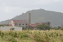
During past centuries, Arroyo was known for the production of sugar in the Central Lafayette,[31] a sugar mill.[7][32]
In recent years, manufacture and pharmaceutical industries have taken control of the economy of Arroyo. Stryker Corporation, a developer of medical implants and other surgical equipment, has a production plant in the town.
Government
Since its foundation, Arroyo's municipal government has been led by a mayor, with its first mayor being Marcelino Cintrón. The current mayor is Eric Bachier Román. The city also has a municipal legislature that handles local legislative matters.[24]
The city belongs to the Puerto Rico Senatorial district VI, which is represented by two Senators. In 2012, Miguel Pereira Castillo and Angel Rodríguez Otero were elected as District Senators.[33]
Symbols
Arroyo's flag has two horizontal bands of equal size. The upper band is color orange, while the lower one is black. In the middle of the flag lies Arroyo's coat of arms.[1]
The coat of arms is also split in two sections. The upper section features a church in a blue field a church with a rosary to the right and a flower to the left. The lower section features two silver telegraph poles on green hills. At the bottom, waving stripes of blue and silver, with a fish below them. Above the shield, lies a crown of three towers filled in with purple. Below there's a banner with the motto, Arroyo Pueblo Grato.[1]
Education
Education is handled by the Puerto Rico Department of Education. Arroyo has seven elementary schools, three junior high schools, and one high school.
Transportation
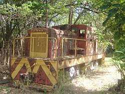

During the peak of the sugarcane industry in the island, Arroyo was part of the railroad system of the island, with trains hauling production to other municipalities in the island. A small portion of that train remained in use until recently for tourism purposes, under the name of Tren del Sur.
To reach Arroyo, visitors have to take the Puerto Rico Highway 3. However, there are other rural roads available to reach the municipality.
There are 13 bridges in Arroyo.[34]
Notable people
- Carmen Bozello Guzmán de Huyke, one of three known female Puerto Rican nineteenth-century playwrights who wrote a comedy entitled Abnegación y Sacrificio: Comedia en 2 Actos y en Prosa (which premiered on October 15, 1876 in Puerto Rico and was printed by Cayetano Sánchez y Vegas in 1876).[35]
- Juan Bernardo Huyke, former interim Governor of Puerto Rico.
- Alberto A. Nido, former United States Air Force officer.
- José Cruz, baseball player, former player for the Houston Astros.
- Jake Rodríguez, former IBF light welterweight champion.
- Génesis Dávila, beauty pageant, former Miss Mundo Puerto Rico and Miss Florida USA.
- Rafael Román Meléndez, former Secretary of Education of Puerto Rico.
- Celiangely Morales, sprinter, competed at the 2016 Summer Olympics.
- Héctor Soto, known as Picky Soto, professional volleyball player, captain and former member of the Puerto Rico men's national volleyball team.
- Monica Gonzalez Rivera, female boxer
- Francisco Javier Amy, poet and prose writer who wrote and published a collection of poems entitled Ecos y Notas: (Colección de poesías.)
- Max E. “Chuma” Sánchez, first athlete from Arroyo to obtain a medal in the Central American and Caribbean games in Panamá in 1938.
- María Socorro Lacot, Secretary of the Department of Public Education 1979.
Gallery
 Central plaza in Arroyo barrio-pueblo
 Our Lady of Carmen Parish church
 Casa Aduana in Arroyo
 Pier in Arroyo
References
- "Arroyo Municipality Founding History and Symbols". enciclopediapr.org. Fundación Puertorriqueña de las Humanidades (FPH). Archived from the original on 14 February 2019. Retrieved 14 February 2019.
- "NY/Latino Journal; Taking the PE Out of PRT; by: Rafael Merino Cortes; July 20, 2006". Archived from the original on 2009-09-03. Retrieved 2011-10-12.
- "150th. Anniversary of the Foundation of Arroyo, Puerto Rico". Archived from the original on 2011-12-08. Retrieved 2011-10-12.
- "Welcome to Puerto Rico". Archived from the original on 2011-10-12. Retrieved 2011-10-12.
- Joseph Prentiss Sanger; Henry Gannett; Walter Francis Willcox (1900). Informe sobre el censo de Puerto Rico, 1899, United States. War Dept. Porto Rico Census Office (in Spanish). Imprenta del gobierno. p. 162. Retrieved 2019-02-14.
- Congress (1955). Congressional Record. Government Printing Office. pp. 5–. GGKEY:U89J4XBC3CK. Archived from the original on 2019-02-14. Retrieved 2019-02-14.
- "Arroyo Municipality General Info (Location, Square Miles, Economy and Geography)". enciclopediapr.org. Fundación Puertorriqueña de las Humanidades (FPH). Archived from the original on 14 February 2019. Retrieved 14 February 2019.
- "Preliminary Locations of Landslide Impacts from Hurricane Maria, Puerto Rico". USGS Landslide Hazards Program. USGS. Archived from the original on 2019-03-03. Retrieved 2019-03-03.
- "Preliminary Locations of Landslide Impacts from Hurricane Maria, Puerto Rico" (PDF). USGS Landslide Hazards Program. USGS. Archived (PDF) from the original on 2019-03-03. Retrieved 2019-03-03.
- Gwillim Law (20 May 2015). Administrative Subdivisions of Countries: A Comprehensive World Reference, 1900 through 1998. McFarland. p. 300. ISBN 978-1-4766-0447-3. Retrieved 25 December 2018.
- Puerto Rico:2010:population and housing unit counts.pdf (PDF). U.S. Dept. of Commerce, Economics and Statistics Administration, U.S. Census Bureau. 2010. Archived (PDF) from the original on 2017-02-20. Retrieved 2018-12-28.
- "Map of Arroyo at the Wayback Machine" (PDF). Archived from the original (PDF) on 2018-03-24. Retrieved 2018-12-29.
- "US Census Barrio-Pueblo definition". factfinder.com. US Census. Archived from the original on 13 May 2017. Retrieved 5 January 2019.
- "Agencia: Oficina del Coordinador General para el Financiamiento Socioeconómico y la Autogestión (Proposed 2016 Budget)". Puerto Rico Budgets (in Spanish). Retrieved 28 June 2019.
- Rivera Quintero, Marcia (2014), El vuelo de la esperanza: Proyecto de las Comunidades Especiales Puerto Rico, 1997-2004 (first ed.), San Juan, Puerto Rico Fundación Sila M. Calderón, ISBN 978-0-9820806-1-0
- "Leyes del 2001". Lex Juris Puerto Rico (in Spanish). Retrieved 24 June 2020.
- Rivera Quintero, Marcia (2014), El vuelo de la esperanza:Proyecto de las Comunidades Especiales Puerto Rico, 1997-2004 (Primera edición ed.), San Juan, Puerto Rico Fundación Sila M. Calderón, p. 273, ISBN 978-0-9820806-1-0
- "U.S. Decennial Census". United States Census Bureau. Archived from the original on February 13, 2020. Retrieved September 21, 2017.
- "Report of the Census of Porto Rico 1899". War Department Office Director Census of Porto Rico. Archived from the original on July 16, 2017. Retrieved September 21, 2017.
- "Table 3-Population of Municipalities: 1930 1920 and 1910" (PDF). United States Census Bureau. Archived (PDF) from the original on August 17, 2017. Retrieved September 21, 2017.
- "Table 4-Area and Population of Municipalities Urban and Rural: 1930 to 1950" (PDF). United States Census Bureau. Archived (PDF) from the original on August 30, 2015. Retrieved September 21, 2014.
- "Table 2 Population and Housing Units: 1960 to 2000" (PDF). United States Census Bureau. Archived (PDF) from the original on July 24, 2017. Retrieved September 21, 2017.
- "Las 1,200 playas de Puerto Rico [The 1200 beaches of Puerto Rico]". Primera Hora (in Spanish). April 14, 2017. Archived from the original on December 12, 2019. Retrieved December 12, 2019.
- "Arroyo Municipality Festivals, Places". enciclopediapr.org. Fundación Puertorriqueña de las Humanidades (FPH). Archived from the original on 14 February 2019. Retrieved 14 February 2019.
- U.S. Geological Survey Geographic Names Information System: Playa Las Palmas
- U.S. Geological Survey Geographic Names Information System: Punta Guilarte
- Peffer, Randall (2002-10-01). Lonely Planet. Lonely Planet Publications. p. 240.
Which is the only working railroad on the island, (outside the one in the park at Bayamón)
- "Puerto Rico Festivales, Eventos y Actividades en Puerto Rico". Puerto Rico Hoteles y Paradores (in Spanish). Retrieved 2020-07-17.
- Gutiérrez, Izarys (June 26, 2019). "Museo Antigua Aduana de Arroyo: historia, arte y cultura". Voces del Sur (digital newspaper). Retrieved February 21, 2020.
- Eurospace, Inc. (2011). "Teatro Renacimiento Arroyo, P.R.: A NEW SCENARIO". eurospaceblog (Blog). Retrieved February 21, 2020.
- "Lafayette". jaimemontilla.com. Retrieved 2020-02-22.
- Nadia Amoroso (27 February 2015). Representing Landscapes: Digital. Routledge. pp. 255–. ISBN 978-1-317-55323-6. Archived from the original on 14 February 2019. Retrieved 14 February 2019.
- Elecciones Generales 2012: Escrutinio General Archived January 15, 2013, at the Wayback Machine on CEEPUR
- "Arroyo Bridges". National Bridge Inventory Data. US Dept. of Transportation. Archived from the original on 20 February 2019. Retrieved 19 February 2019.
- "Escritoras de la América Hispánica: Una obra dramática de Carmen Bozello". Escritoras de la América Hispánica. Retrieved 2020-02-22.